10-Day Weather Forecast - Marion, OH
Weekend Weather
- |69°F
 40% Chance of StormsHourly details
Tonight
69°FPartly cloudy with a chance of showers and thunderstorms late this evening then mostly cloudy. Patchy fog. Lows in the mid 60s. West winds around 5 mph. Chance of rain 40 percent.
- 84|66°F
 Partly SunnyHourly details
Day
84°FPartly sunny in the morning then clearing. Patchy fog in the morning. Humid with highs in the mid 80s. North winds 5 to 10 mph.
Night
66°F
Partly cloudy in the evening then clearing. Lows in the lower 60s. East winds 5 to 10 mph.
- 88|72°FPartly CloudyHourly details
Day
88°FMostly sunny in the morning then becoming partly cloudy. Highs in the upper 80s. Southeast winds 5 to 10 mph.
Night
72°F
Mostly cloudy with a chance of showers. Humid with lows in the upper 60s. Southeast winds around 5 mph. Chance of rain 30 percent.
- 81|72°F
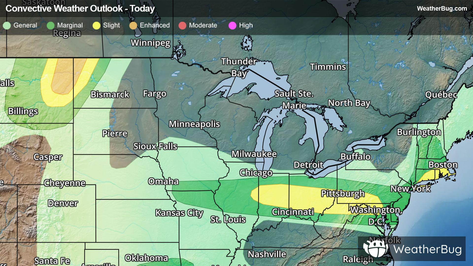
 70% Chance of StormsHourly details
Day
81°FPartly sunny with a chance of showers in the morning then mostly cloudy with showers likely with a chance of thunderstorms in the afternoon. Highs in the upper 80s. Chance of rain 70 percent.
Night
72°FA chance of thunderstorms in the evening. Showers likely. Lows around 70. Chance of rain 70 percent.
- 83|73°F60% Chance of StormsHourly details
Day
83°FShowers likely with a chance of thunderstorms. Highs in the upper 80s. Chance of rain 60 percent.
Night
73°FMostly cloudy with a chance of showers and thunderstorms in the evening then partly cloudy after midnight. Lows in the lower 70s. Chance of rain 40 percent.
- 89|73°F40% Chance of StormsHourly details
Day
89°FPartly sunny with a chance of showers. A chance of thunderstorms in the afternoon. Hot with highs in the lower 90s. Chance of rain 40 percent. Heat index values in the upper 90s.
Night
73°FMostly cloudy with a chance of showers and thunderstorms. Lows in the lower 70s. Chance of rain 40 percent.
- 87|69°F40% Chance of StormsHourly details
Day
87°FPartly sunny with a chance of showers and thunderstorms. Hot with highs in the lower 90s. Chance of rain 40 percent.
Night
69°FMostly cloudy with a chance of showers and thunderstorms in the evening then partly cloudy after midnight. Lows in the upper 60s. Chance of rain 40 percent.
Weekend Weather
- 84|67°F
 40% Chance Rain Showers
Day
84°FPartly sunny. A chance of showers in the afternoon. Highs in the upper 80s. Chance of rain 40 percent.
Night
67°F
Mostly clear with a chance of rain. Chance of precipitation 50%. Low temperature around 67F. Dew point will be around 62F with an average humidity of 71%. Winds will be 3 mph from the SW.
- 79|65°F
 50% Chance of Rain
Day
79°FPartly cloudy with a chance of rain. Chance of precipitation 45%. High temperature around 79F. Dew point will be around 63F with an average humidity of 67%. Winds will be 4 mph from the W.
Night
65°FPartly cloudy with a 45% chance for rain and thunderstorms. Low temperature around 65F. Dew point will be around 61F with an average humidity of 74%. Winds will be 2 mph from the W.
- 78|64°F40% Chance of Rain
Day
78°FMostly sunny with a chance of rain. Chance of precipitation 35%. High temperature around 78F. Dew point will be around 60F with an average humidity of 66%. Winds will be 3 mph from the W.
Night
64°FMostly clear with a chance of rain. Chance of precipitation 35%. Low temperature around 64F. Dew point will be around 58F with an average humidity of 71%. Winds will be 2 mph from the SW.