10-Day Weather Forecast - Melvin, IA
- 81|59°FSunnyHourly details
Today
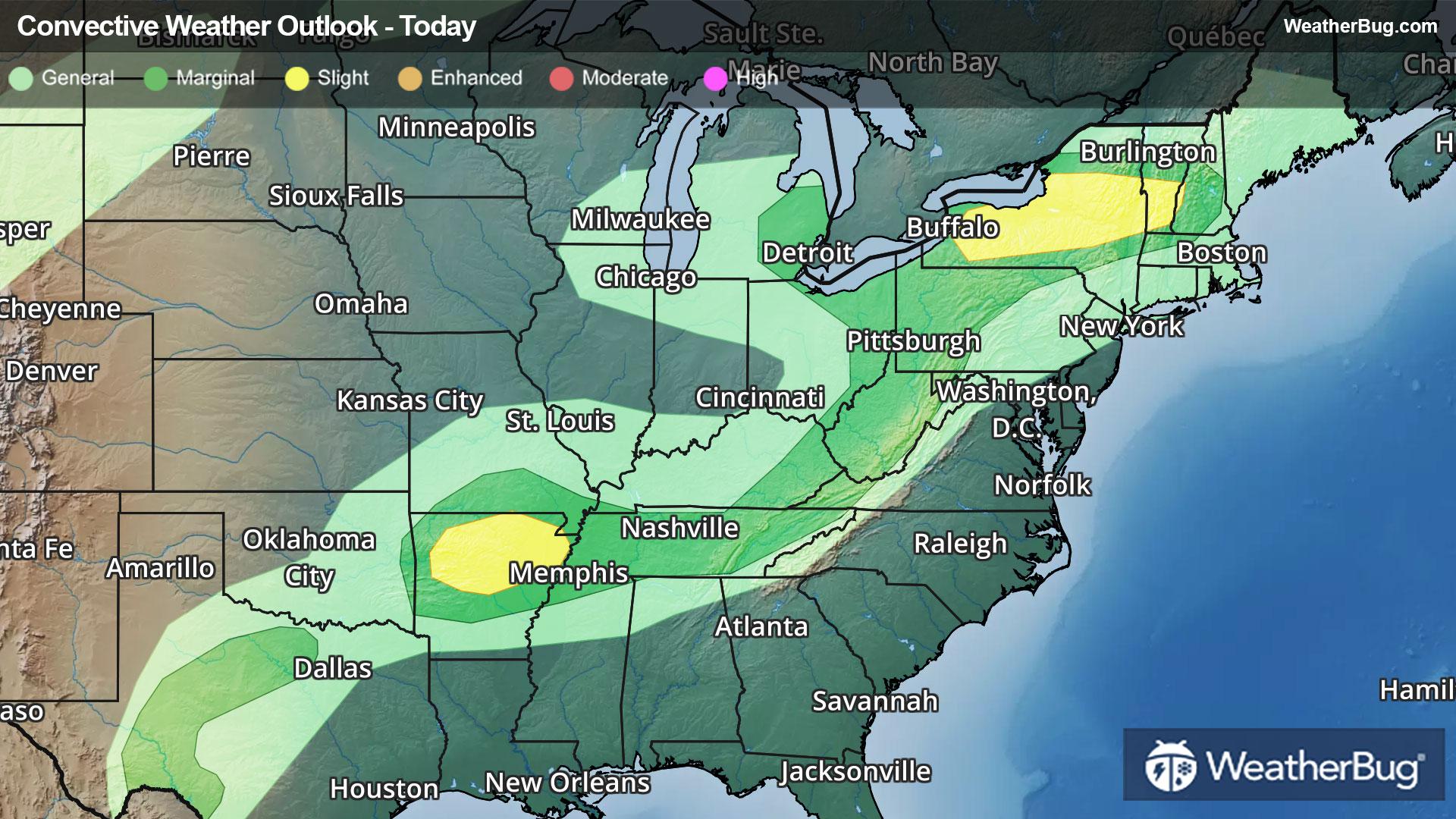
81°FSunny warmer with highs in the lower 80s. South winds around 20 mph with gusts up to 30 mph.
Tonight
59°FMostly clear. Not as cool with lows in the mid 50s. South winds 15 to 20 mph with gusts up to 30 mph.
- 58|28°F50% Chance of StormsHourly details
Day
58°FMostly cloudy with a chance of showers with a slight chance of thunderstorms. Breezy and much cooler with highs in the lower 60s. Temperature falling into the upper 40s in the afternoon. Southeast winds 15 to 20 mph with gusts up to 30 mph becoming northwest 20 to 25 mph with gusts up to 40 mph in the afternoon. Chance of rain 50 percent.
Night
28°FPartly cloudy and breezy. Much cooler with lows in the upper 20s. Northwest winds 20 to 25 mph with gusts up to 35 mph.
Weekend Weather
- 47|29°FSunnyHourly details
Day
47°FSunny breezy cooler with highs in the upper 40s. Northwest winds 20 to 25 mph with gusts up to 35 mph.
Night
29°FMostly clear. Lows in the upper 20s.
- 56|33°FSunnyHourly details
Day
56°FSunny. Highs in the upper 50s.
Night
33°FMostly clear. Lows in the lower 30s.
- 69|48°FSunnyHourly details
Day
69°FSunny. Much warmer with highs in the lower 70s.
Night
48°FMostly clear. Not as cool with lows in the upper 40s.
- 76|48°FSunnyHourly details
Day
76°FSunny. Highs in the mid 70s.
Night
48°FMostly clear. Lows in the upper 40s.
- 75|54°FSunny
Day
75°FSunny. Highs in the upper 70s.
Night
54°FMostly cloudy with a 40% chance for rain and thunderstorms. Low temperature around 54F. Dew point will be around 45F with an average humidity of 62%. Winds will be 17 mph from the SE.
- 70|47°F50% Chance of Rain
Day
70°FCloudy with a 50% chance for rain and thunderstorms. High temperature around 70F. Dew point will be around 50F with an average humidity of 63%. Winds will be 11 mph from the S.
Night
47°FCloudy with a 55% chance for rain and thunderstorms. Low temperature around 47F. Dew point will be around 45F with an average humidity of 66%. Winds will be 9 mph from the SE.
- 60|38°F40% Chance of Rain
Day
60°FCloudy with a chance of rain. Chance of precipitation 40%. High temperature around 60F. Dew point will be around 43F with an average humidity of 63%. Winds will be 3 mph from the NE.
Night
38°FCloudy with a slight chance of rain. Chance of precipitation 30%. Low temperature around 38F. Dew point will be around 36F with an average humidity of 67%. Winds will be 4 mph from the N.
Weekend Weather
- 53|34°FCloudy
Day
53°FCloudy. High temperature around 53F. Dew point will be around 34F with an average humidity of 59%. Winds will be 9 mph from the N.
Night
34°FMostly cloudy with a slight chance of rain. Chance of precipitation 30%. Low temperature around 34F. Dew point will be around 30F with an average humidity of 67%. Winds will be 7 mph from the N.