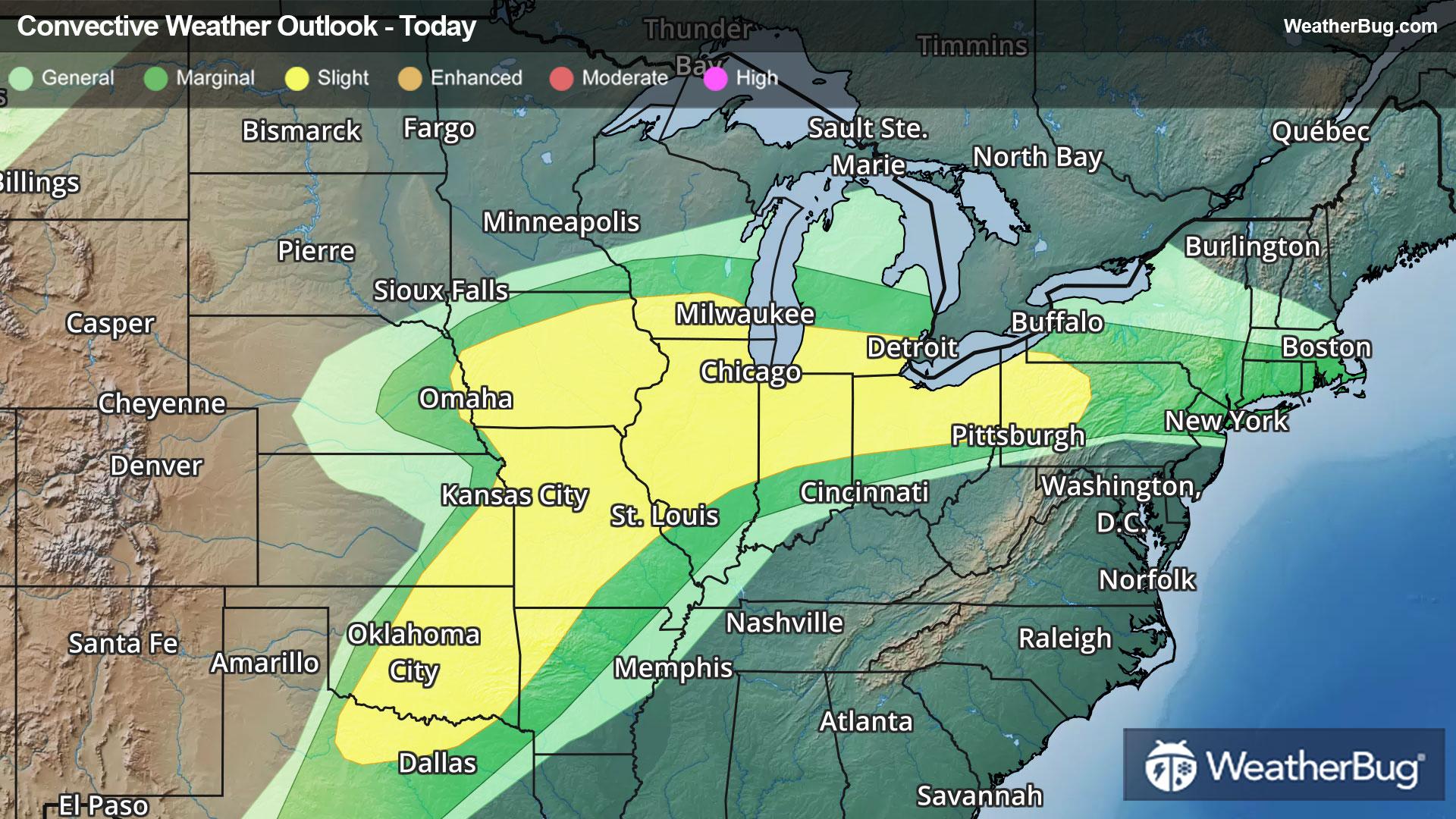
10-Day Weather Forecast - Mont-Saint-Michel, Quebec, CA
- 49|42°F70% Chance of RainHourly details
Today
49°FCloudy with probable rain. Chance of precipitation 65%. High temperature around 49F. Dew point will be around 40F with an average humidity of 90%. Winds will be 3 mph from the SE.
Tonight
42°FMostly cloudy. Low temperature around 42F. Dew point will be around 42F with an average humidity of 95%. Winds will be 2 mph from the SE.
- 52|43°F70% Chance of RainHourly details
Day
52°FCloudy with probable rain. Chance of precipitation 65%. High temperature around 52F. Dew point will be around 46F with an average humidity of 97%. Winds will be 2 mph from the SE.
Night
43°FCloudy with a chance of rain. Chance of precipitation 55%. Low temperature around 43F. Dew point will be around 44F with an average humidity of 98%. Winds will be 3 mph from the N.
- 58|41°FPartly CloudyHourly details
Day
58°FPartly cloudy. High temperature around 58F. Dew point will be around 43F with an average humidity of 75%. Winds will be 4 mph from the N.
Night
41°FMostly clear. Low temperature around 41F. Dew point will be around 40F with an average humidity of 77%. Winds will be 3 mph from the SE.
Weekend Weather
- 62|44°F40% Chance of RainHourly details
Day
62°FMostly cloudy with a chance of rain. Chance of precipitation 35%. High temperature around 62F. Dew point will be around 47F with an average humidity of 77%. Winds will be 10 mph from the S.
Night
44°FMostly cloudy with likely rain. Chance of precipitation 90%. Low temperature around 44F. Dew point will be around 48F with an average humidity of 84%. Winds will be 9 mph from the S.
- 42|25°F50% Chance of RainHourly details
Day
42°FMostly cloudy with a chance of rain. Chance of precipitation 50%. High temperature around 42F. Dew point will be around 30F with an average humidity of 66%. Winds will be 11 mph from the W.
Night
25°FPartly cloudy. Low temperature around 25F. Dew point will be around 19F with an average humidity of 61%. Winds will be 10 mph from the NW.
- 34|23°FPartly CloudyHourly details
Day
34°FPartly cloudy. High temperature around 34F. Dew point will be around 10F with an average humidity of 45%. Winds will be 11 mph from the NW.
Night
23°FMostly clear. Low temperature around 23F. Dew point will be around 11F with an average humidity of 52%. Winds will be 5 mph from the NW.
- 42|34°F40% Chance Frozen Mix
Day
42°FCloudy with a chance of rain-snow mix. Chance of precipitation 35%. High temperature around 42F. Dew point will be around 18F with an average humidity of 49%. Winds will be 8 mph from the S.
Night
34°FMostly cloudy with a chance of rain. Chance of precipitation 40%. Low temperature around 34F. Dew point will be around 30F with an average humidity of 77%. Winds will be 6 mph from the S.
- 46|32°F30% Chance of Rain
Day
46°FCloudy with a slight chance of rain. Chance of precipitation 30%. High temperature around 46F. Dew point will be around 32F with an average humidity of 73%. Winds will be 6 mph from the W.
Night
32°FCloudy. Low temperature around 32F. Dew point will be around 29F with an average humidity of 75%. Winds will be 2 mph from the NW.
- 46|33°FCloudy
Day
46°FCloudy. High temperature around 46F. Dew point will be around 28F with an average humidity of 64%. Winds will be 3 mph from the NW.
Night
33°FPartly cloudy. Low temperature around 33F. Dew point will be around 28F with an average humidity of 73%. Winds will be 2 mph from the NW.
- 47|35°FPartly Cloudy
Day
47°FPartly cloudy. High temperature around 47F. Dew point will be around 29F with an average humidity of 64%. Winds will be 2 mph from the N.
Night
35°FCloudy. Low temperature around 35F. Dew point will be around 30F with an average humidity of 73%. Winds will be 1 mph from the N.