10-Day Weather Forecast - Shelocta, PA
- |66°F
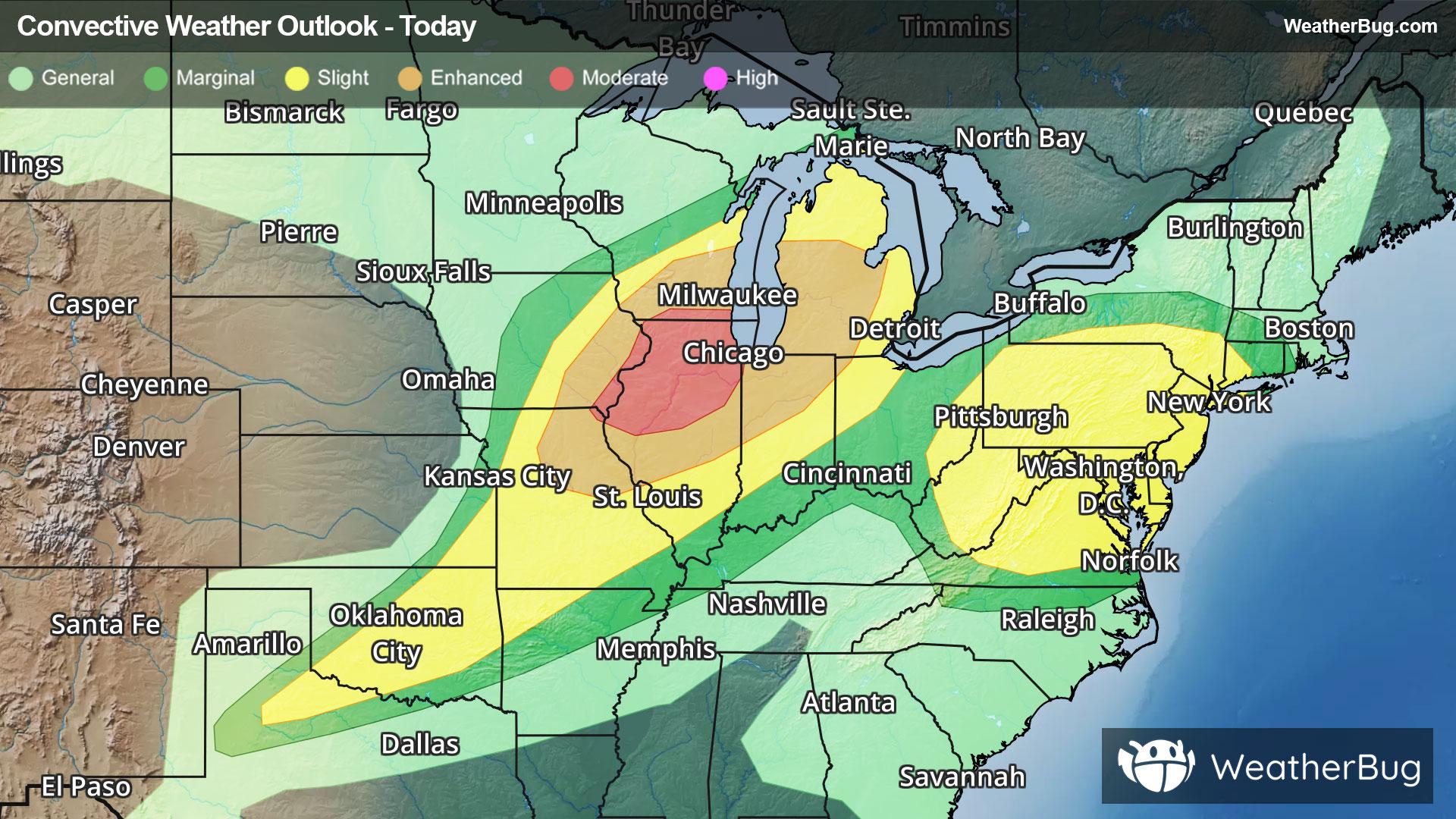
 40% Chance of StormsHourly details
Tonight
66°FMostly cloudy. A slight chance of showers and thunderstorms early this evening then a chance of showers. Lows in the upper 60s. Southwest winds 5 to 10 mph. Chance of rain 40 percent.
- 80|58°F
 70% Chance of StormsHourly details
Day
80°FShowers likely. A slight chance of thunderstorms in the morning then a chance of thunderstorms in the afternoon. Humid with highs in the lower 80s. West winds 5 to 10 mph with gusts up to 25 mph. Chance of rain 70 percent.
Night
58°F
Mainly clear. Less humid with lows in the upper 50s. West winds 5 to 10 mph.
Weekend Weather
- 82|62°F
 Mostly SunnyHourly details
Day
82°FMostly sunny. Highs in the lower 80s. West winds 5 to 10 mph.
Night
62°FMainly clear. Lows in the lower 60s. South winds around 5 mph.
- 78|56°FThunderstormsHourly details
Day
78°FPartly sunny with a chance of showers in the morning then cloudy with showers with a chance of thunderstorms in the afternoon. Highs in the lower 80s. Temperatures falling into the mid 70s in the afternoon. Chance of rain 90 percent.
Night
56°FMostly cloudy. Showers with a chance of thunderstorms in the evening then a chance of showers after midnight. Lows in the lower 50s. Chance of rain 90 percent.
- 71|53°F
 Partly CloudyHourly details
Day
71°FPartly cloudy. Highs in the lower 70s.
Night
53°F
Partly cloudy. Lows in the lower 50s.
- 73|55°FPartly CloudyHourly details
Day
73°FPartly cloudy. Highs in the mid 70s.
Night
55°FPartly cloudy. Lows in the lower 50s.
- 75|62°F40% Chance of StormsHourly details
Day
75°FPartly cloudy in the morning then partly sunny with a chance of showers and thunderstorms in the afternoon. Highs in the upper 70s. Chance of rain 40 percent.
Night
62°FPartly cloudy. A chance of showers and thunderstorms in the evening. Lows in the upper 50s. Chance of rain 40 percent.
- 77|62°F70% Chance of Storms
Day
77°FPartly sunny with a chance of showers in the morning then mostly cloudy with showers likely with a chance of thunderstorms in the afternoon. Highs in the lower 80s. Chance of rain 70 percent.
Night
62°F
Mostly cloudy with probable rain. Chance of precipitation 75%. Low temperature around 62F. Dew point will be around 64F with an average humidity of 88%. Winds will be 7 mph from the SW.
- 76|58°F
 50% Chance of Rain
Day
76°FMostly sunny with a chance of rain. Chance of precipitation 50%. High temperature around 76F. Dew point will be around 64F with an average humidity of 79%. Winds will be 8 mph from the W.
Night
58°FClear with a slight chance of rain. Chance of precipitation 30%. Low temperature around 58F. Dew point will be around 59F with an average humidity of 84%. Winds will be 4 mph from the W.
Weekend Weather
- 75|57°F40% Chance of Rain
Day
75°FSunny with a chance of rain. Chance of precipitation 35%. High temperature around 75F. Dew point will be around 61F with an average humidity of 76%. Winds will be 5 mph from the W.
Night
57°FClear with a chance of rain. Chance of precipitation 35%. Low temperature around 57F. Dew point will be around 58F with an average humidity of 84%. Winds will be 3 mph from the W.