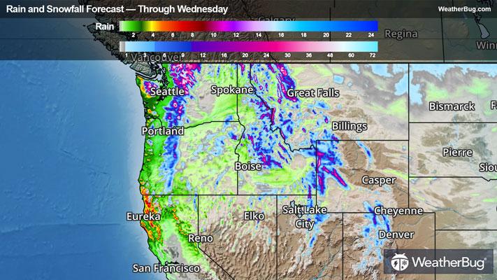
10-Day Weather Forecast - Surprise Station, CA
- 54|49°FRainHourly details
Today
54°FCloudy with likely rain. Chance of precipitation 90%. High temperature around 54F. Dew point will be around 43F with an average humidity of 92%. Winds will be 5 mph from the SW.
Tonight
49°FRain until well after midnight then rain showers well after midnight. Lows in the mid 30s to lower 40s. Windy. Southwest winds 10 to 20 mph increasing to 25 to 35 mph late this evening and overnight. Gusts up to 50 mph. Chance of precipitation 90 percent.
- 48|41°F40% Chance Frozen MixHourly details
Day
48°FMostly cloudy. Chance of rain and snow showers in the morning. Snow level 4800 feet. Highs in the mid 40s to lower 50s. Windy. West winds 25 to 35 mph with gusts to around 50 mph decreasing to 15 to 25 mph with gusts to around 40 mph in the afternoon. Chance of precipitation 40 percent.
Night
41°FMostly cloudy with rain and snow showers likely. Snow level 6000 feet after midnight. No snow accumulation. Lows in the lower to mid 30s. Windy. South winds 10 to 15 mph increasing to southwest 20 to 30 mph with gusts to around 45 mph well after midnight. Chance of precipitation 60 percent.
- 50|44°F70% Chance Rain ShowersHourly details
Day
50°FRain showers likely in the morning then chance of rain showers in the afternoon. Highs in the mid 40s to lower 50s. Windy. Southwest winds 20 to 30 mph with gusts to around 50 mph. Chance of showers 70 percent.
Night
44°FMostly cloudy with a 30 percent chance of rain showers. Snow level 7000 feet after midnight. Lows in the mid 30s to lower 40s. Windy. Southwest winds 20 to 30 mph. Gusts up to 50 mph decreasing to 40 mph well after midnight.
- 46|44°FRain ShowersHourly details
Day
46°FRain showers. Breezy. Highs in the mid 40s to lower 50s.
Night
44°FRain showers in the evening then rain and snow showers likely after midnight. Breezy. Lows in the mid 30s to lower 40s.
Weekend Weather
- 45|42°FFrozen MixHourly details
Day
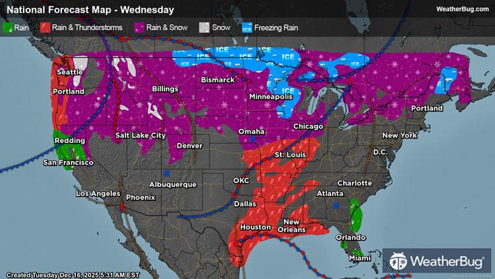
45°FRain and snow showers likely. Highs in the mid 40s to lower 50s.
Night
42°FRain showers likely. Lows in the mid 30s to lower 40s.
- 49|45°FRain ShowersHourly details
Day
49°FRain showers likely in the morning then rain showers in the afternoon. Highs in the mid 40s to lower 50s.
Night
45°FRain showers likely in the evening then rain and snow showers likely after midnight. Lows in the mid 30s to lower 40s.
- 46|40°FFrozen Mix
Day
46°FRain and snow showers likely. Highs in the mid 40s to lower 50s.
Night
40°FMostly cloudy with a chance of rain and snow showers. Lows in the lower to mid 30s. Highs in the mid 40s to lower 50s.
- 44|37°FChance of Frozen Mix
Day
44°FMostly cloudy with a chance of rain and snow showers. Lows in the lower to mid 30s. Highs in the mid 40s to lower 50s.
Night
37°FCloudy with probable rain. Chance of precipitation 70%. Low temperature around 37F. Dew point will be around 32F with an average humidity of 75%. Winds will be 8 mph from the S.
- 40|34°F70% Chance of Rain
Day
40°FCloudy with probable rain. Chance of precipitation 65%. High temperature around 40F. Dew point will be around 32F with an average humidity of 77%. Winds will be 8 mph from the SE.
Night
34°FCloudy with a chance of rain. Chance of precipitation 55%. Low temperature around 34F. Dew point will be around 30F with an average humidity of 76%. Winds will be 6 mph from the S.
- 36|29°F60% Chance of Rain
Day
36°FCloudy with a chance of rain. Chance of precipitation 60%. High temperature around 36F. Dew point will be around 28F with an average humidity of 75%. Winds will be 5 mph from the S.
Night
29°FCloudy with a chance of rain-snow mix. Chance of precipitation 55%. Low temperature around 29F. Dew point will be around 25F with an average humidity of 74%. Winds will be 4 mph from the SE.