10-Day Weather Forecast - Waterville, KS
- |44°FPartly CloudyHourly details
Tonight
44°FPartly cloudy. Near steady temperature in the upper 40s. East winds 10 to 15 mph.
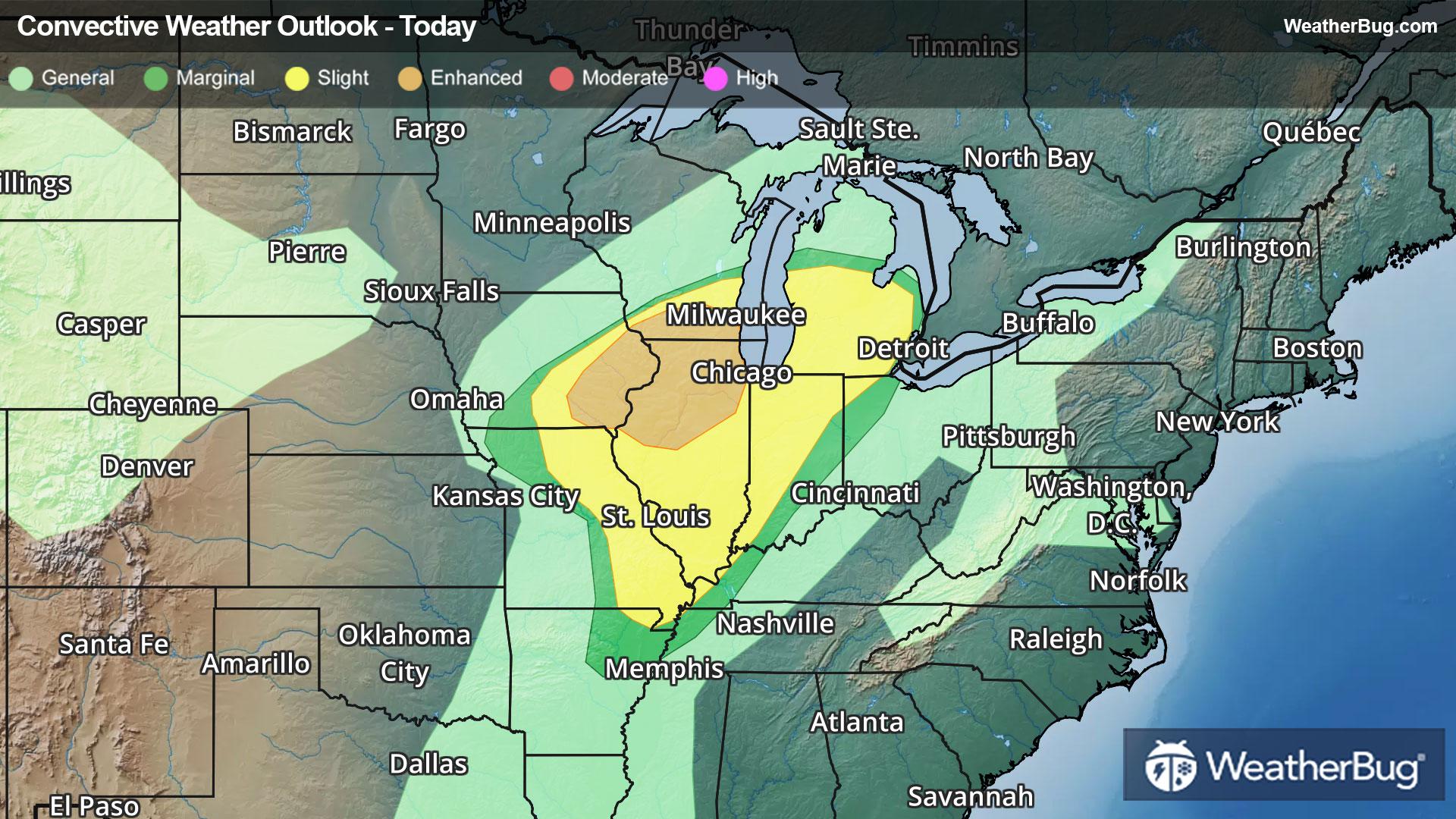
- 66|36°F50% Chance of StormsHourly details
Day
66°FCloudy in the morning then becoming mostly sunny. A chance of showers. A slight chance of thunderstorms in the afternoon. Warmer with highs in the lower 70s. Temperature falling into the mid 60s in the afternoon. South winds 10 to 15 mph becoming west 15 to 20 mph in the afternoon. Chance of rain 50 percent.
Night
36°FMostly clear in the evening then becoming partly cloudy. Cooler with lows in the lower 30s. Northwest winds 10 to 15 mph with gusts up to 25 mph.
Weekend Weather
- 55|33°FSunnyHourly details
Day
55°FSunny. Much cooler with highs in the mid 50s. Northwest winds 15 to 20 mph with gusts up to 30 mph.
Night
33°FClear cold with lows in the lower 30s. Northwest winds 5 to 10 mph.
- 65|40°FMostly SunnyHourly details
Day
65°FMostly clear. Highs in the mid 60s. Lows in the mid 30s.
Night
40°FMostly clear. Highs in the mid 60s. Lows in the mid 30s.
- 56|36°FChance of RainHourly details
Day
56°FPartly sunny with a slight chance of rain. Highs in the upper 50s.
Night
36°FMostly cloudy. A chance of rain in the evening then a slight chance of rain and snow after midnight. Cold with lows in the lower 30s. Chance of precipitation 40 percent.
- 57|49°FChance of RainHourly details
Day
57°FPartly sunny. A slight chance of rain in the afternoon. Highs in the upper 50s.
Night
49°FPartly cloudy. A slight chance of showers. Breezy. Lows in the lower 40s. Highs in the mid 70s.
- 73|50°FChance of Rain ShowersHourly details
Day
73°FPartly cloudy. A slight chance of showers. Breezy. Lows in the lower 40s. Highs in the mid 70s.
Night
50°FA slight chance of thunderstorms in the evening. Partly cloudy with a chance of showers. Lows in the upper 40s. Chance of rain 50 percent.
- 62|49°F50% Chance Rain Showers
Day
62°FMostly cloudy with a 50 percent chance of showers. Highs in the upper 60s.
Night
49°FCloudy with a 55% chance for rain and thunderstorms. Low temperature around 49F. Dew point will be around 49F with an average humidity of 87%. Winds will be 7 mph from the SE.
- 58|47°F70% Chance of Rain
Day
58°FCloudy with a 70% chance for rain and thunderstorms. High temperature around 58F. Dew point will be around 51F with an average humidity of 89%. Winds will be 5 mph from the SE.
Night
47°FCloudy with a 65% chance for rain and thunderstorms. Low temperature around 47F. Dew point will be around 48F with an average humidity of 89%. Winds will be 4 mph from the SE.
Weekend Weather
- 60|46°F70% Chance of Rain
Day
60°FCloudy with a 65% chance for rain and thunderstorms. High temperature around 60F. Dew point will be around 50F with an average humidity of 86%. Winds will be 4 mph from the S.
Night
46°FCloudy with a 50% chance for rain and thunderstorms. Low temperature around 46F. Dew point will be around 49F with an average humidity of 88%. Winds will be 3 mph from the S.