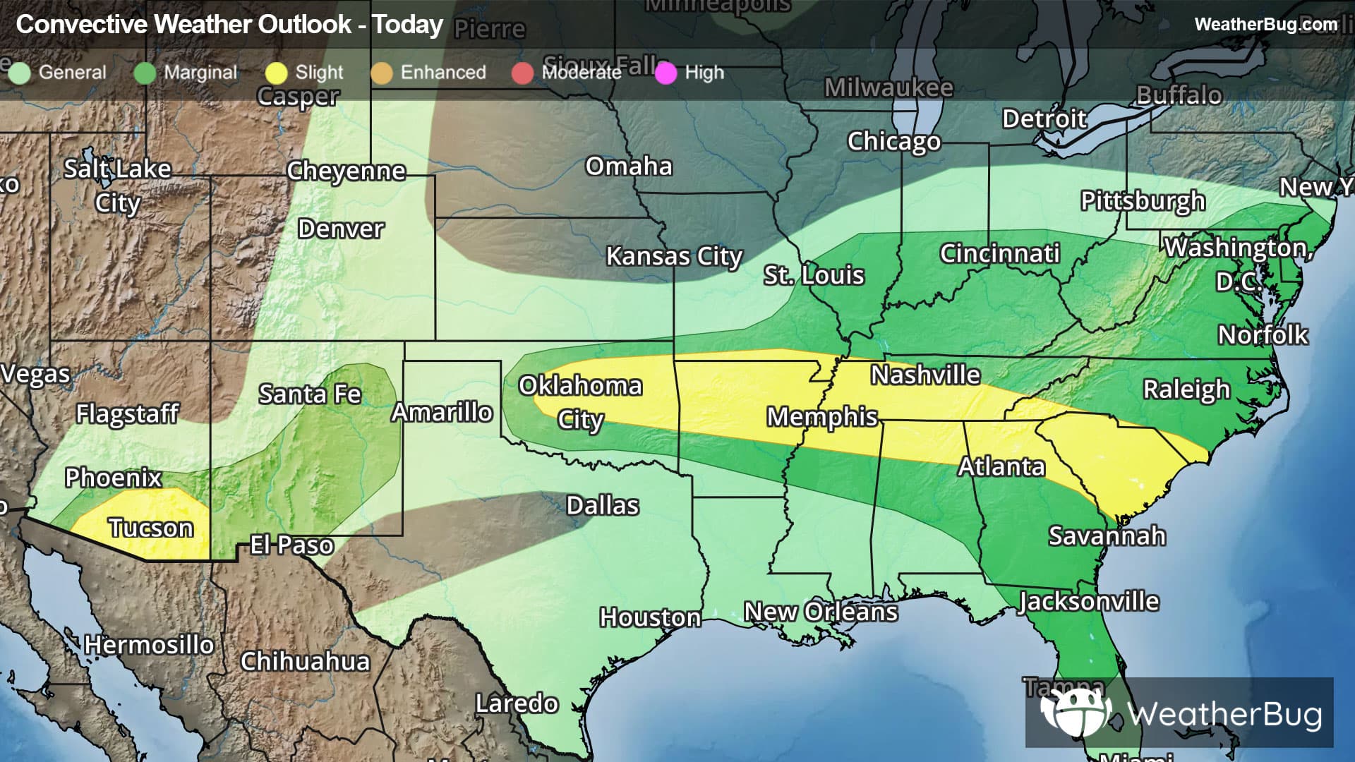
Severe Storms Launch in South, Desert Southwest
As strong, monsoon-season thunderstorms boil up in the Desert Southwest, ingredients for severe thunderstorms align in the South this afternoon and evening.
Read More
# HEADLINE -------------------- COASTAL FLOOD ADVISORY REMAINS IN EFFECT UNTIL 11 PM EDT THIS EVENING # SUMMARY -------------------- Maurice River at Bivalve MLLW Categories - Minor 7.6 ft, Moderate 8.6 ft, Major 9.6 ft MHHW Categories - Minor 1.3 ft, Moderate 2.3 ft, Major 3.3 ft Total Total Departure Day/Time Tide Tide from Norm Flood ft MLLW ft MHHW ft Impact -------- --------- --------- --------- -------- 11/07 PM 7.9 1.6 1.1 Minor 12/08 AM 6.1 -0.2 0.9 None 12/08 PM 8.0 1.7 1.0 Minor 13/08 AM 6.0 -0.3 0.9 None 13/09 PM 7.9 1.6 0.8 Minor 14/10 AM 6.1 -0.2 0.6 None Atlantic Ocean at Atlantic City MLLW Categories - Minor 6.0 ft, Moderate 7.0 ft, Major 8.0 ft MHHW Categories - Minor 1.4 ft, Moderate 2.4 ft, Major 3.4 ft Total Total Departure Day/Time Tide Tide from Norm Flood ft MLLW ft MHHW ft Impact -------- --------- --------- --------- -------- 11/06 PM 6.4 1.8 1.3 Minor 12/06 AM 4.8 0.2 1.1 None 12/06 PM 6.4 1.8 1.0 Minor 13/07 AM 4.4 -0.2 0.5 None 13/07 PM 6.0 1.4 0.5 Minor 14/08 AM 4.3 -0.3 0.2 None Great Egg Harbor Bay at Ocean City MLLW Categories - Minor 5.3 ft, Moderate 6.3 ft, Major 7.3 ft MHHW Categories - Minor 1.3 ft, Moderate 2.3 ft, Major 3.3 ft Total Total Departure Day/Time Tide Tide from Norm Flood ft MLLW ft MHHW ft Impact -------- --------- --------- --------- -------- 11/06 PM 5.5 1.5 0.8 Minor 12/07 AM 4.2 0.2 0.9 None 12/07 PM 5.6 1.6 0.7 Minor 13/08 AM 3.9 -0.1 0.5 None 13/08 PM 5.5 1.5 0.4 Minor 14/08 AM 3.6 -0.4 0.2 None Cape May Harbor at Cape May MLLW Categories - Minor 6.2 ft, Moderate 7.2 ft, Major 8.2 ft MHHW Categories - Minor 1.1 ft, Moderate 2.1 ft, Major 3.1 ft Total Total Departure Day/Time Tide Tide from Norm Flood ft MLLW ft MHHW ft Impact -------- --------- --------- --------- -------- 11/06 PM 6.7 1.6 1.0 Minor 12/07 AM 5.2 0.1 1.1 None 12/07 PM 7.0 1.9 1.0 Minor 13/08 AM 5.0 -0.1 0.7 None 13/08 PM 6.8 1.7 0.6 Minor 14/09 AM 4.9 -0.2 0.4 None # DETAILS -------------------- WHAT Up to one foot of inundation above ground level expected in low-lying areas near shorelines and tidal waterways. WHERE Cumberland, Atlantic, Cape May, Atlantic Coastal Cape May and Coastal Atlantic. WHEN Until 11 PM EDT this evening. IMPACTS At this level, flooding begins on the most vulnerable roads in coastal and bayside communities, and along inland tidal waterways. Some partial or full road closures are possible. ADDITIONAL DETAILS Minor tidal flooding is expected to continue for the evening high tides on Sunday and potentially Monday as well. Further Coastal Flood Advisories may be needed. ISSUED AT Saturday, July 11, 2026 at 4:27 PM EDT ISSUED BY National Weather Service Mount Holly NJ HEADER Coastal Hazard Message # PRECAUTIONARY/PREPAREDNESS ACTIONS -------------------- A Coastal Flood Advisory means that minor tidal flooding is expected. Minor tidal flooding often results in some road closures. Usually, the most vulnerable roadways will flood. Do not leave your vehicle at a location that is prone to tidal flooding. Do not drive your vehicle through flood waters. The water may be deeper than you think it is. You will be putting yourself in danger and your vehicle may be damaged, leading to costly repairs. Visit the National Water Prediction Service at https://water.noaa.gov/wfo/phi for additional water level and flood impact information for your local tide gauge. # AREAS AFFECTED -------------------- Coastal Atlantic, Atlantic, Atlantic Coastal Cape May, Cape May, Cumberland
There is a Marginal Severe Storm Risk for your location. Continue reading for today's outlook from the National Weather Service's Storm Prediction Center. -------------------- National Severe Storm Outlook THERE IS A SLIGHT RISK OF SEVERE THUNDERSTORMS FOR PORTIONS OF CENTRAL OKLAHOMA TO THE CAROLINA SHORELINE...AND SOUTHERN ARIZONA SUMMARY Thunderstorms capable of producing scattered severe/damaging winds will remain possible this afternoon and evening from parts of the southern Plains eastward into the lower Mississippi Valley and Southeast. Scattered severe wind gusts are still possible over southern Arizona late this afternoon through the evening. 20Z Update The previous forecast (see below) remains largely on track. The only appreciable change made to the 20Z Day 1 Outlook was to trim severe probabilities from the TX Panhandle. Here, subsidence and stability persist, with MLCINH of at least -100 J/kg in place amid minimal low-level convergence or upper support to encourage diurnal thunderstorm development. However, a few nocturnal storms may form due to impinging convective outflow from OK. Elsewhere across the CONUS, only minor changes were made to the general thunder and severe probabilities to reflect the latest observations and guidance consensus.