Severe Storms Fire Up Across The Great Lakes and Ohio Valley
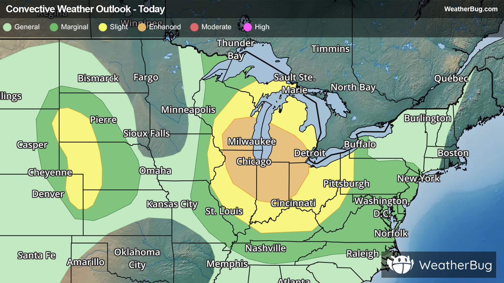
Strong to severe thunderstorms are expected to develop across the Great Lakes and Ohio Valley today.
Read More
# HEADLINE -------------------- EXTREME HEAT WARNING NOW IN EFFECT UNTIL 7 AM CDT TUESDAY HEAT ADVISORY NOW IN EFFECT FROM 7 AM TO 7 PM CDT TUESDAY # DETAILS -------------------- WHAT For the Extreme Heat Warning, dangerously hot conditions with heat index values up to 115. For the Heat Advisory, heat index values up to 110 expected. WHERE Portions of southeast Kansas and central, east central, south central, southwest, and west central Missouri. WHEN For the Extreme Heat Warning, until 7 AM CDT Tuesday. For the Heat Advisory, from 7 AM to 7 PM CDT Tuesday. IMPACTS Heat related illnesses increase significantly during extreme heat and high humidity events. Hot temperatures and high humidity may cause heat illnesses. ISSUED AT Sunday, July 26, 2026 at 11:48 AM CDT ISSUED BY National Weather Service Springfield MO HEADER URGENT - WEATHER MESSAGE # PRECAUTIONARY/PREPAREDNESS ACTIONS -------------------- Drink plenty of fluids, stay in an air-conditioned room, stay out of the sun, and check up on relatives and neighbors. # AREAS AFFECTED -------------------- Laclede, Lawrence, Taney, Barry, Barton, Benton, Bourbon, Camden, Cedar, Cherokee, Christian, Crawford, Dade, Dallas, Dent, Douglas, Greene, Hickory, Howell, Jasper, Maries, McDonald, Miller, Morgan, Newton, Oregon, Ozark, Phelps, Polk, Pulaski, Shannon, St. Clair, Stone, Texas, Vernon, Webster, Wright Including the cities of Rome, Joplin, Buffalo, Roach, Teresita, Stippville, Thayer, Forsyth, Laurie, Plato, Pittsburg, Edgewater Beach, Foose, Northview, Kenoma, Sherwin, Lowell, Graff, Pawnee Station, Gladden, Edmonson, Darien, Pottersville, Monett, Huggins, Neosho, South West City, Aurora Springs, Marionville, Baxter Springs, Weaubleau, Arnica, Charity, Squires, Hollister, Elsey, Montier, Mountain Grove, Decaturville, Bendavis, Vanzant, Fort Leonard Wood, Crane, Crockerville, Jadwin, Meinert, El Dorado Springs, March, Lone Oak, Ozark, Columbus, Madry, Lake Spring, Nixa, Bangert, South Fork, Springfield, White Church, Waynesville, Howes, Powersite, Quincy, Ozark Beach, Duncan, Goodman, Fort Scott, Indian Point, Mansfield, Caplinger Mills, Lebanon, Wheatland, Bolivar, Cross Timbers, Laquey, Christian Center, Cedar Springs, Rocky Mount, Village of Four Seasons, Dawson, Mount Vernon, Silver Dollar City, Eldon, Lamar, Greer, Pineville, Windyville, Branson, Hermitage, Cole Camp, Camdenton, Birch Tree, Stover, Plad, Pomona, Neutral, Whitakerville, Filley, Roby, Marshfield, Olive, Appleton City, Ava, Greenfield, Lockwood, West Plains, Salem, Northwye, Kimberling City, Rocky Comfort, Noel, Versailles, Tiffin, Aurora, Lincoln, Osage Beach, Stockton, Seymour, Warsaw, Thomasville, Selmore, Chicopee, Mora, Lynchburg, Riverton, Wasola, Couch, Carthage, Anderson, Lake Ozark, Rolla, Vichy, Johnson City, Rogersville, Cassville, Dogwood, Nevada, Siloam Springs, Winona, Kirbyville, Wilderness, Alton, and Goodhope
# HEADLINE -------------------- EXTREME HEAT WARNING NOW IN EFFECT UNTIL 7 AM CDT TUESDAY HEAT ADVISORY NOW IN EFFECT FROM 7 AM TO 7 PM CDT TUESDAY # DETAILS -------------------- WHAT For the Extreme Heat Warning, dangerously hot conditions with heat index values up to 115. For the Heat Advisory, heat index values up to 110 expected. WHERE Portions of southeast Kansas and central, east central, south central, southwest, and west central Missouri. WHEN For the Extreme Heat Warning, until 7 AM CDT Tuesday. For the Heat Advisory, from 7 AM to 7 PM CDT Tuesday. IMPACTS Heat related illnesses increase significantly during extreme heat and high humidity events. Hot temperatures and high humidity may cause heat illnesses. ISSUED AT Sunday, July 26, 2026 at 11:48 AM CDT ISSUED BY National Weather Service Springfield MO HEADER URGENT - WEATHER MESSAGE # PRECAUTIONARY/PREPAREDNESS ACTIONS -------------------- Drink plenty of fluids, stay in an air-conditioned room, stay out of the sun, and check up on relatives and neighbors. # AREAS AFFECTED -------------------- Laclede, Lawrence, Taney, Barry, Barton, Benton, Bourbon, Camden, Cedar, Cherokee, Christian, Crawford, Dade, Dallas, Dent, Douglas, Greene, Hickory, Howell, Jasper, Maries, McDonald, Miller, Morgan, Newton, Oregon, Ozark, Phelps, Polk, Pulaski, Shannon, St. Clair, Stone, Texas, Vernon, Webster, Wright Including the cities of Rome, Joplin, Buffalo, Roach, Teresita, Stippville, Thayer, Forsyth, Laurie, Plato, Pittsburg, Edgewater Beach, Foose, Northview, Kenoma, Sherwin, Lowell, Graff, Pawnee Station, Gladden, Edmonson, Darien, Pottersville, Monett, Huggins, Neosho, South West City, Aurora Springs, Marionville, Baxter Springs, Weaubleau, Arnica, Charity, Squires, Hollister, Elsey, Montier, Mountain Grove, Decaturville, Bendavis, Vanzant, Fort Leonard Wood, Crane, Crockerville, Jadwin, Meinert, El Dorado Springs, March, Lone Oak, Ozark, Columbus, Madry, Lake Spring, Nixa, Bangert, South Fork, Springfield, White Church, Waynesville, Howes, Powersite, Quincy, Ozark Beach, Duncan, Goodman, Fort Scott, Indian Point, Mansfield, Caplinger Mills, Lebanon, Wheatland, Bolivar, Cross Timbers, Laquey, Christian Center, Cedar Springs, Rocky Mount, Village of Four Seasons, Dawson, Mount Vernon, Silver Dollar City, Eldon, Lamar, Greer, Pineville, Windyville, Branson, Hermitage, Cole Camp, Camdenton, Birch Tree, Stover, Plad, Pomona, Neutral, Whitakerville, Filley, Roby, Marshfield, Olive, Appleton City, Ava, Greenfield, Lockwood, West Plains, Salem, Northwye, Kimberling City, Rocky Comfort, Noel, Versailles, Tiffin, Aurora, Lincoln, Osage Beach, Stockton, Seymour, Warsaw, Thomasville, Selmore, Chicopee, Mora, Lynchburg, Riverton, Wasola, Couch, Carthage, Anderson, Lake Ozark, Rolla, Vichy, Johnson City, Rogersville, Cassville, Dogwood, Nevada, Siloam Springs, Winona, Kirbyville, Wilderness, Alton, and Goodhope