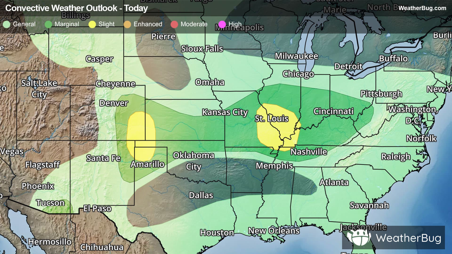
Weather Alerts For Columbia, IA
Dense Fog Advisory
-URGENT - WEATHER MESSAGE National Weather Service Des Moines IA 345 AM CST Sun Dec 28 2025 Audubon-Guthrie-Dallas-Polk-Cass-Adair-Madison-Warren-Marion- Mahaska-Adams-Union-Clarke-Lucas-Monroe-Wapello-Taylor-Ringgold- Decatur-Wayne-Appanoose-Davis- Including the cities of Oskaloosa, Adel, Earlham, Pella, Panora, Adair, Creston, Chariton, Lenox, Leon, Carlisle, Exira, Fontanelle, Audubon, Winterset, Humeston, Des Moines, Bayard, Greenfield, Corydon, Osceola, Lamoni, Allerton, Albia, Casey, Mount Ayr, Seymour, Ottumwa, Bedford, Perry, Atlantic, Guthrie Center, Norwalk, Corning, Stuart, Bloomfield, Waukee, Knoxville, New Market, Centerville, and Indianola 345 AM CST Sun Dec 28 2025 ...DENSE FOG ADVISORY REMAINS IN EFFECT UNTIL 6 AM CST EARLY THIS MORNING... ...WIND ADVISORY REMAINS IN EFFECT FROM 9 AM THIS MORNING TO 6 AM CST MONDAY... * WHAT...For the Dense Fog Advisory, visibility one quarter mile or less in dense fog. For the Wind Advisory, northwest winds 25 to 35 mph with gusts up to 45 mph expected. * WHERE...Portions of central, south central, southeast, southwest, and west central Iowa. * WHEN...For the Dense Fog Advisory, until 6 AM CST early this morning. For the Wind Advisory, from 9 AM this morning to 6 AM CST Monday. * IMPACTS...Gusty winds will blow around unsecured objects. Tree limbs could be blown down and a few power outages may result. Low visibility could make driving conditions hazardous. PRECAUTIONARY/PREPAREDNESS ACTIONS... Winds this strong can make driving difficult, especially for high profile vehicles. Use extra caution. If driving, slow down, use your headlights, and leave plenty of distance ahead of you. &&
Wind Advisory
-URGENT - WEATHER MESSAGE National Weather Service Des Moines IA 345 AM CST Sun Dec 28 2025 Audubon-Guthrie-Dallas-Polk-Cass-Adair-Madison-Warren-Marion- Mahaska-Adams-Union-Clarke-Lucas-Monroe-Wapello-Taylor-Ringgold- Decatur-Wayne-Appanoose-Davis- Including the cities of Oskaloosa, Adel, Earlham, Pella, Panora, Adair, Creston, Chariton, Lenox, Leon, Carlisle, Exira, Fontanelle, Audubon, Winterset, Humeston, Des Moines, Bayard, Greenfield, Corydon, Osceola, Lamoni, Allerton, Albia, Casey, Mount Ayr, Seymour, Ottumwa, Bedford, Perry, Atlantic, Guthrie Center, Norwalk, Corning, Stuart, Bloomfield, Waukee, Knoxville, New Market, Centerville, and Indianola 345 AM CST Sun Dec 28 2025 ...DENSE FOG ADVISORY REMAINS IN EFFECT UNTIL 6 AM CST EARLY THIS MORNING... ...WIND ADVISORY REMAINS IN EFFECT FROM 9 AM THIS MORNING TO 6 AM CST MONDAY... * WHAT...For the Dense Fog Advisory, visibility one quarter mile or less in dense fog. For the Wind Advisory, northwest winds 25 to 35 mph with gusts up to 45 mph expected. * WHERE...Portions of central, south central, southeast, southwest, and west central Iowa. * WHEN...For the Dense Fog Advisory, until 6 AM CST early this morning. For the Wind Advisory, from 9 AM this morning to 6 AM CST Monday. * IMPACTS...Gusty winds will blow around unsecured objects. Tree limbs could be blown down and a few power outages may result. Low visibility could make driving conditions hazardous. PRECAUTIONARY/PREPAREDNESS ACTIONS... Winds this strong can make driving difficult, especially for high profile vehicles. Use extra caution. If driving, slow down, use your headlights, and leave plenty of distance ahead of you. &&