Tropical Storm Bertha Crawls Along Gulf Coast
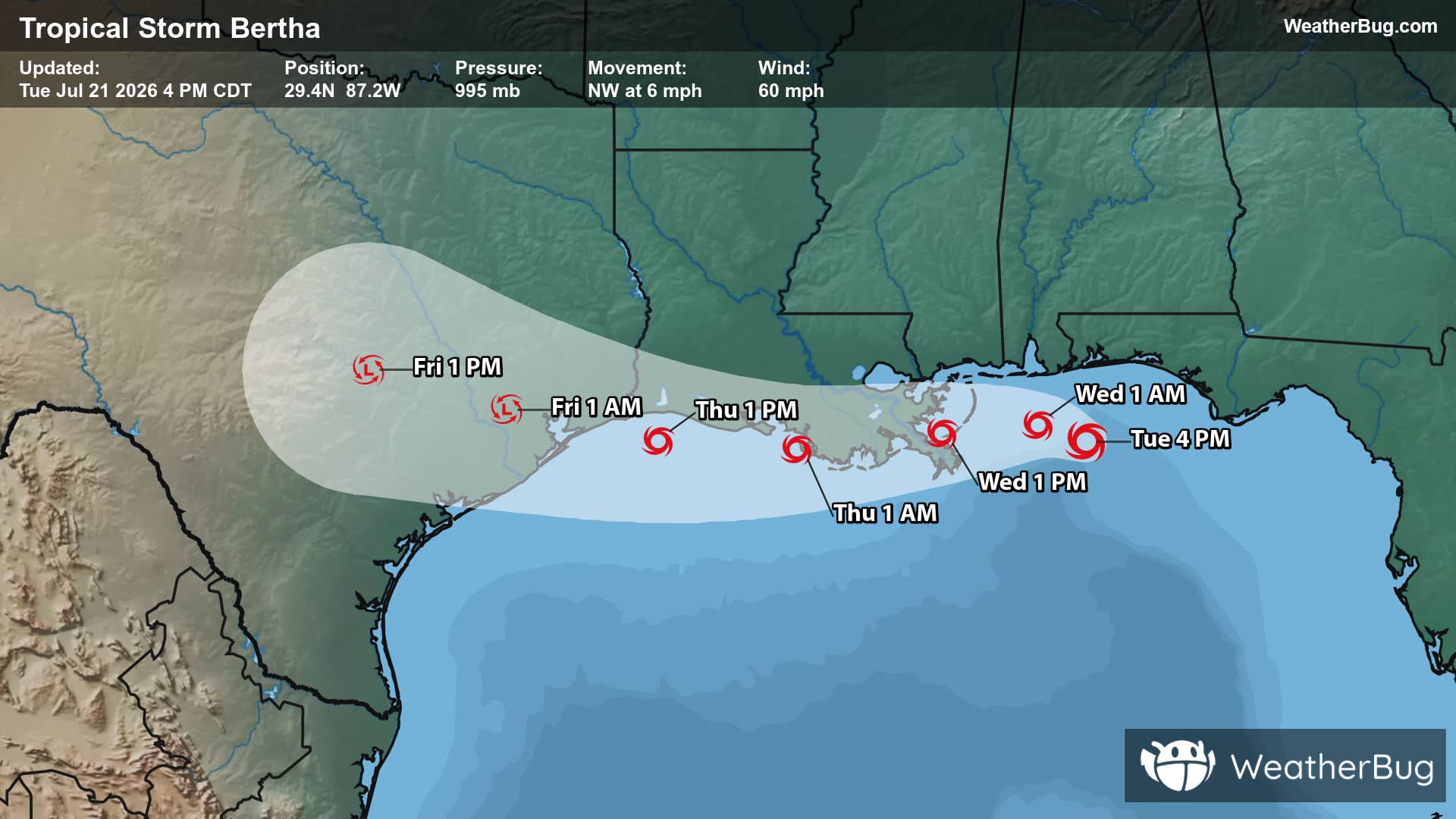
Tropical Storm Bertha is the Atlantic's second named storm of the season.
Read More
# HEADLINE -------------------- FLOOD WATCH NOW IN EFFECT UNTIL 2 AM EDT WEDNESDAY # DETAILS -------------------- WHAT Flash flooding caused by excessive rainfall continues to be possible. WHERE Portions of central, north central, northeast, and northern Maryland, including the following areas, in central Maryland, Central and Southeast Howard, Central and Southeast Montgomery, Northwest Howard and Northwest Montgomery. In north central Maryland, Carroll and Frederick. In northeast Maryland, Cecil. In northern Maryland, Northern Baltimore, Northwest Harford, Southeast Harford and Southern Baltimore. WHEN Until 2 AM EDT Wednesday. IMPACTS Excessive runoff may result in flooding of rivers, creeks, streams, and other low-lying and flood-prone locations. Flooding may occur in poor drainage and urban areas. Extensive street flooding and flooding of creeks and rivers are possible. ADDITIONAL DETAILS - Repeated very heavy rain may result in areas of 3 to 6 inches of rainfall and considerable flash flooding this evening. - Please visit www.weather.gov/safety/flood for flood safety and preparedness information ISSUED AT Tuesday, July 21, 2026 at 6:17 PM EDT ISSUED BY National Weather Service Baltimore MD/Washington DC HEADER URGENT - IMMEDIATE BROADCAST REQUESTED | Flood Watch # PRECAUTIONARY/PREPAREDNESS ACTIONS -------------------- You should monitor later forecasts and be prepared to take action should Flash Flood Warnings be issued. # AREAS AFFECTED -------------------- Northwest Montgomery, Carroll, Cecil, Central and Southeast Howard, Central and Southeast Montgomery, Frederick, Northern Baltimore, Northwest Harford, Northwest Howard, Southeast Harford, Southern Baltimore
# SUMMARY -------------------- THE NATIONAL WEATHER SERVICE HAS ISSUED SEVERE THUNDERSTORM WATCH 509 IN EFFECT UNTIL 10 PM EDT THIS EVENING FOR THE FOLLOWING AREAS THE DISTRICT OF COLUMBIA IN MARYLAND THIS WATCH INCLUDES 16 COUNTIES IN CENTRAL MARYLAND ANNE ARUNDEL HOWARD MONTGOMERY PRINCE GEORGES IN NORTH CENTRAL MARYLAND CARROLL FREDERICK WASHINGTON IN NORTHEAST MARYLAND CECIL IN NORTHERN MARYLAND BALTIMORE BALTIMORE CITY HARFORD IN SOUTHERN MARYLAND CALVERT CHARLES ST. MARYS IN WESTERN MARYLAND ALLEGANY GARRETT IN VIRGINIA THIS WATCH INCLUDES 34 COUNTIES IN CENTRAL VIRGINIA ALBEMARLE CITY OF CHARLOTTESVILLE CITY OF FREDERICKSBURG GREENE KING GEORGE NELSON ORANGE SPOTSYLVANIA IN NORTHERN VIRGINIA ARLINGTON CITY OF ALEXANDRIA CITY OF FAIRFAX CITY OF FALLS CHURCH CITY OF MANASSAS CITY OF MANASSAS PARK CULPEPER FAIRFAX FAUQUIER LOUDOUN PRINCE WILLIAM STAFFORD IN NORTHWEST VIRGINIA CITY OF WINCHESTER CLARKE FREDERICK MADISON PAGE RAPPAHANNOCK SHENANDOAH WARREN IN WESTERN VIRGINIA AUGUSTA CITY OF HARRISONBURG CITY OF STAUNTON CITY OF WAYNESBORO HIGHLAND ROCKINGHAM IN WEST VIRGINIA THIS WATCH INCLUDES 8 COUNTIES IN EASTERN WEST VIRGINIA GRANT HAMPSHIRE HARDY MINERAL PENDLETON IN PANHANDLE WEST VIRGINIA BERKELEY JEFFERSON MORGAN THIS INCLUDES THE CITIES OF ABERDEEN, ABINGDON, ADAMS MORGAN, ADEN, AIRLIE, ALBIN, ALEXANDRIA, ALONZAVILLE, ALSOP, ANDORA, ANNANDALE, ANNAPOLIS, ANTIOCH, APPLETON, ARCO, ARKENDALE, ARLINGTON, ARNOLD, BAKERTON, BALLENGER CREEK, BALLSTON, BALTIMORE, BARCROFT, BARKSDALE, BAY VIEW, BEAN SETTLEMENT, BENTONVILLE, BERKELEY SPGS, BERRYVILLE, BERRYVILLE, BETHEL, BETHESDA, BLAKE, BLOOMERY, BOHEMIAS MILLS, BOWIE, BOYDS, BRADY, BRAKE, BRANDYWINE, BRANTWOOD, BROKENBURG, BROOKFIELD, BROOMES ISLAND, BUCKEYSTOWN, BUCKTON, BURKE, BURR HILL, BYNUM, CABINS, CALIFORNIA, CALLAWAY, CARDOVA, CATALPA, CATONSVILLE, CEDAR GROVE, CEDARVILLE, CHANTILLY, CHARLES TOWN, CHARLOTTESVILLE, CHERRYDALE, CHESAPEAKE BEACH, CHESTER GAP, CHRISTIAN, CHURCHVILLE, CLARKSVILLE, CLARY, CLINTON, CLOVER CREEK, COLLEGE PARK, COLUMBIA, COMPTON, COUNTRYSIDE, COVE POINT, CULPEPER, CUMBERLAND, DAHLGREN, DALE CITY, DAMERON, DRUM POINT, DULLES INTERNATIONAL AIRPORT, DUNDALK, DUNKIRK, EDGEWOOD, ELDERSBURG, ELLERSLIE, ESSEX, EVERONA, FAIRFAX, FAIRFAX STATION, FAIRVIEW, FALLS CHURCH, FALMOUTH, FELLS POINT, FISHER, FIVE FORKS, FORDSVILLE, FORT ASHBY, FOUR CORNERS, FRANKLIN, FREDERICK, FREDERICKSBURG, FRENCHBURG, FRONT ROYAL, FROSTBURG, GAINESBORO, GAITHERSBURG, GAMBER, GARRISONVILLE, GATEWOOD, GERMANTOWN, GLEEDSVILLE, GLEN BURNIE, GLEN ECHO, GLENDIE, GLENMONT, GRANTSVILLE, GREENBELT, GREENFIELD, HAGERSTOWN, HALFWAY, HAMBURG, HANCOCK, HARFORD FURNACE, HARRISONBURG, HAWKINSTOWN, HEADSVILLE, HICKORY, HIGHTOWN, HISTORIC ELLICOTT CITY, HOWELLSVILLE, INDEPENDENT HILL, KEYSER, KIMBALL, KLINE GAP, LAHORE, LAKE RIDGE, LANDES, LANGLEY, LEESBURG, LEXINGTON PARK, LIBERTY, LINVILLE, LONG BEACH, LUCKETTS, LURAY, MADISON MILLS, MADISON RUN, MAGNOLIA, MAGNOLIA, MANASSAS, MANASSAS PARK, MARTINSBURG, MASONVILLE, MASSAPONAX, MCCOOLE, MCDOWELL, MCLEAN, MCNEILL, MIDDLEWAY, MILL GAP, MILLVILLE, MONTCLAIR, MONTEBELLO, MONTEREY, MONTPELIER, MOOREFIELD, MOUNT CLIFTON, MOUNT HARMONY, MOUNT JACKSON, MOUNTAIN LAKE PARK, MUSTOE, NASONS, NEW CREEK, OAK FLAT, OAK GROVE, OAKLAND, ORANGE, OVERTON, PARK HEIGHTS, PARK MILLS, PARKVILLE, PARTLOW, PAW PAW, PETERSBURG, PINEY POINT, POINTS, POST OAK, PURGITSVILLE, RANDALLSTOWN, RANSON, RAPIDAN, RAWLINGS, REAGAN NATIONAL AIRPORT, RESTON, REVA, RIDGE, RIDGEVILLE, RIDGEWAY, RILEYVILLE, RIVERCREST, RIVERTON, ROLLINS FORK, ROMNEY, ROSSLYN, RUDDLE, RUSSELLDALE, SEVERN, SEVERNA PARK, SEYMOURVILLE, SHADY GROVE, SHADY GROVE, SHENANDOAH JUNCTION, SHILOH, SILVER SPRING, SIMPSONVILLE, SKYLAND, SMITH CROSSROADS, SOTTERLEY, SOUTH GATE, SPOTSYLVANIA COURT, SPOTTSWOOD, SPRINGFIELD, ST. CHARLES, STAUNTON, STERLING PARK, STEVENSBURG, STRASBURG, STRINGTOWN, STUARTS DRAFT, SUGAR GROVE, SUITLAND-SILVER HILL, TANTALLON, THREE CHURCHES, TOWSON, TURNBULL, TWYMANS MILL, UNIONVILLE, WALDORF, WAPOCOMO, WARRENTON, WASHINGTON, WAYNESBORO, WELTON, WESTMINSTER, WIDEWATER, WINCHESTER, WINSTON, WOODBRIDGE, WOODLAWN, WOODSTOCK, AND WOODSTOCK. # DETAILS -------------------- ISSUED AT Tuesday, July 21, 2026 at 2:47 PM EDT ISSUED BY NATIONAL WEATHER SERVICE BALTIMORE MD/WASHINGTON DC HEADER WATCH COUNTY NOTIFICATION FOR WATCH 509
Closest strike: 1.36 miles Stay Alert! Remain in a safe area until there has been no lightning within 10 miles of this location for 30 minutes. Please be aware that lightning activity can remain high even when a storm is moving away from your location. Even if rain has stopped, do not leave your safe area until WeatherBug indicates that lightning is more than 10 miles away from this selected location. IF OUTDOORS Avoid water, high ground, and open spaces. Avoid all metal objects including electric wires, fences, and machinery. Find a safe area in a building or in a fully enclosed vehicle with the windows completely shut. Unsafe places include underneath canopies, small picnic or rain shelters, convertibles, or near trees. IF INDOORS Avoid water and stay away from doors and windows. Avoid using a hard line telephone. Take off headphones. Turn off, unplug, and stay away from appliances, computers, power tools, and TV sets. Lightning may strike exterior electric and phone lines, inducing shocks to inside equipment.
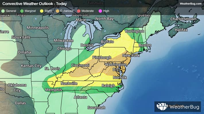
There is a Enhanced Severe Storm Risk for your location. Continue reading for today's outlook from the National Weather Service's Storm Prediction Center. -------------------- National Severe Storm Outlook THERE IS AN ENHANCED RISK OF SEVERE THUNDERSTORMS FROM PORTIONS OF THE NORTHEAST AND MID ATLANTIC TO THE OHIO VALLEY SUMMARY Numerous severe thunderstorms are expected across a broad region from the Tennessee and Ohio Valleys to the Mid-Atlantic and Northeast States into tonight. Swaths of damaging wind gusts are expected to be the most common impact, but some tornadoes and hail are possible as well. 20z Update Mid Atlantic and New England A complicated convective situation continues across the area with numerous cluster of strong to severe storms ongoing from southern NY/CT/MA to the DelMarVA. A diffuse warm frontal zone from the Hudson valley to Long Island and the Atlantic coast has supported a few instances of stronger rotating supercells and QLCS structures. This focus may continue as additional more discrete storms approach from northern NJ and eastern PA. Otherwise, clustering of storms ahead of the cold front and across VA will pose a risk for damaging gusts through this evening. The primary update to the outlook was to lower probabilities behind the ongoing convection over NY and northeast OH where the air mass has been partially overturned. Isolated damaging gusts and some hail remain possible tonight. OH Valley A broken band of storms ahead of a cold front, extending into WV and southwest PA should continue to track east/southeast through this afternoon and into the evening hours. Strong northwesterly flow aloft is supporting moderate deep-layer shear and a mixed mode of supercells and clusters across southern IN/OH and into northern KY. A primary risk for damaging winds is expected given upscale growth as storm coverage increases. However, the large buoyancy (MLCAPE 3000-4000 J/kg) and some supercell structures could support large hail. Some tornado potential will also exist with the semi-discreet supercells and QLCS structures. This appears most likely near a convective modified boundary from astern OH into WV and southwest PA. Storm coverage should continue to increase this afternoon across western KY and the lower OH Valley. With a predominately linear storm mode expected along the cold front, damaging winds are the most likely hazard. The primary change to the probabilities was to trim behind the front over OH/IN. See the prior outlook for more information.