Severe Storms Fire Up Across The Great Lakes and Ohio Valley
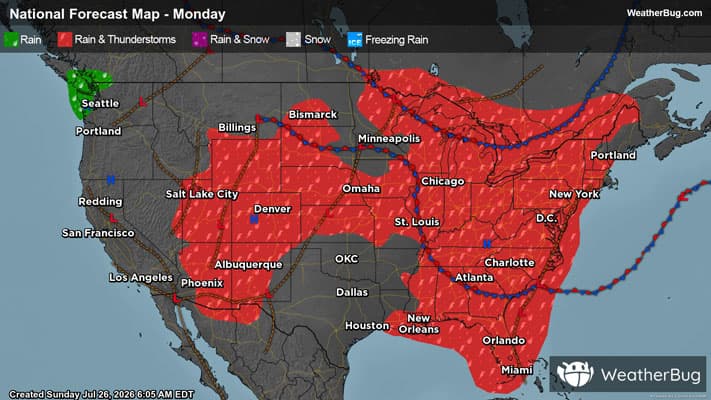
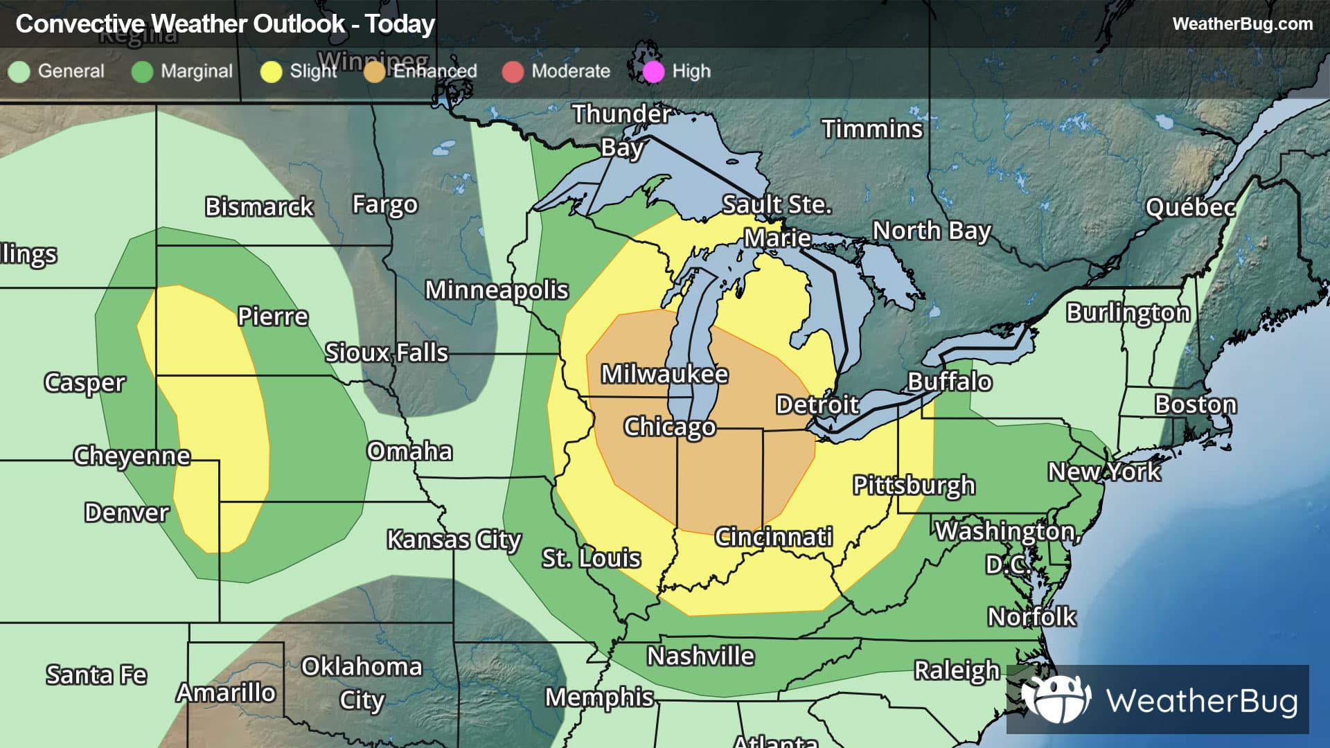
Strong to severe thunderstorms are expected to develop across the Great Lakes and Ohio Valley today.
Read More
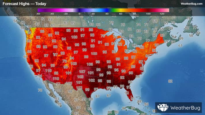
# HEADLINE -------------------- EXTREME HEAT WARNING REMAINS IN EFFECT UNTIL 10 PM CDT MONDAY # DETAILS -------------------- WHAT Dangerously hot conditions with heat index values up to around 110 expected. WHERE Portions of central, north central, northeast, south central, southeast, southwest, and west central Iowa. WHEN Until 10 PM CDT Monday. IMPACTS Heat related illnesses increase significantly during extreme heat and high humidity events. ISSUED AT Sunday, July 26, 2026 at 7:56 PM CDT ISSUED BY National Weather Service Des Moines IA HEADER URGENT - WEATHER MESSAGE # PRECAUTIONARY/PREPAREDNESS ACTIONS -------------------- Drink plenty of fluids, stay in an air-conditioned room, stay out of the sun, and check up on relatives and neighbors. # AREAS AFFECTED -------------------- Adams, Carroll, Polk, Wayne, Adair, Appanoose, Audubon, Black Hawk, Boone, Bremer, Butler, Calhoun, Cass, Clarke, Dallas, Davis, Decatur, Greene, Grundy, Guthrie, Hamilton, Hardin, Jasper, Lucas, Madison, Mahaska, Marion, Marshall, Monroe, Poweshiek, Ringgold, Story, Tama, Taylor, Union, Wapello, Warren, Webster Including the cities of Oskaloosa, Grundy Center, Wellsburg, Corydon, Toledo, Shell Rock, Tama, Mount Ayr, Leon, Waverly, Bedford, Seymour, Aplington, Adair, Atlantic, Greenfield, Exira, Iowa Falls, Humeston, Conrad, Guthrie Center, Fort Dodge, Allison, Ottumwa, Panora, Stuart, Pomeroy, Greene, Jefferson, Rockwell City, Grinnell, Gladbrook, Marshalltown, Perry, Dumont, Waterloo, Audubon, Albia, Des Moines, Earlham, Knoxville, Webster City, Bloomfield, Newton, Corning, Norwalk, Ames, Carroll, Pella, Dysart, Lamoni, Centerville, Osceola, Cedar Falls, Clarksville, Allerton, Dike, Ackley, Bayard, Parkersburg, Adel, Creston, Casey, Reinbeck, Indianola, Lake City, Fontanelle, Manson, Carlisle, Eldora, Lenox, Winterset, Traer, Chariton, Boone, Waukee, and New Market
There is a Marginal Severe Storm Risk for your location. Continue reading for today's outlook from the National Weather Service's Storm Prediction Center. -------------------- National Severe Storm Outlook THERE IS AN ENHANCED RISK OF SEVERE THUNDERSTORMS PORTIONS OF THE UPPER MIDWEST AND WESTERN GREAT LAKES SUMMARY Severe thunderstorms capable of large to very large hail, damaging winds (possibly 75+ mph), and tornado risk remain likely from the upper Mississippi Valley and Great Lakes southwestward into Nebraska, mainly late this evening and tonight. Upper Midwest A very unstable environment remains in place across the region, with the MPX, GRB, and DVN 00Z soundings sampling MLCAPE from 3100, 2900, and 2800 J/kg, respectively. Surface observations show mid to upper 70s dewpoints on the warm side of the warm front extending from north-central MN through northeast WI/far western Upper MI. A thunderstorm has matured upstream of this corridor, with the expectation it will remain strong to severe as it continues southeastward. Modest low-level warm advection into this boundary will also contribute to additional thunderstorms this evening and overnight. Environmental conditions are still expected to support large to very large hail early in the convective cycle while a more cellular mode is likely. Thereafter, a trend towards bowing segments capable of severe wind gusts is anticipated. A singular MCS could eventually develop, with severe gusts possible as it moves southward as well. Some gusts, both within the line segments and early in the MCS lifecycle, could be significant (i.e. over 75 mph). TN Valley A cold-pool-driven MCS continues to propagate south-southeast at approximately 40 kts. The downstream airmass is very moist, with numerous sites reporting dewpoints in the low 80s. This moisture is contributing to extreme buoyancy, with the recent 00Z BNA sounding sampling 4500 J/kg of SBCAPE. This MCS is also oriented perpendicular to the deep-layer vertical shear. All of these factors will contribute to continued southward progression, with an attendant risk for strong gusts likely extending into Middle TN this evening. South-Central into Southeast SD into central NE Numerous attempts at deep convection along the weak surface trough extending from south-central SD through central NE have failed thus far. The window of opportunity for deep convection will likely remain open for the next hour or two before building inhibition associated with nocturnal cooling precludes mature convection. Until that occurs, there remains a conditional risk for severe thunderstorms capable of strong downdrafts and isolated large hail. Elsewhere Increasing thunderstorm coverage is possible across the Mid-Atlantic over the next few hours as a shortwave trough progresses southeastward across the region. Moderate vertical shear could support updraft organization with deeper, more persistent convection. Isolated damaging gusts and hail are possible with the more organized storms. Isolated damaging gusts remain possible across northern Wyoming and far southwest South Dakota as high-based thunderstorms track northeastward across the region this evening. Jackson Hole Wyoming reported a gust of 50 kt at 2353Z.