Severe Storms Fire Up Across Parts of the Midwest
Strong to severe thunderstorms are expected to develop across the Great Lakes and Ohio Valley today.
Read More
A Weather Alert has been issued for a nearby area. While your current location is outside of the impacted area, please stay alert and monitor weather conditions. # SUMMARY -------------------- The National Weather Service in Indianapolis has issued a - Flash Flood Warning for... Eastern Boone County in central Indiana... Southeastern Clinton County in central Indiana... Hamilton County in central Indiana... Madison County in central Indiana... Tipton County in central Indiana... Delaware County in east central Indiana... Northwestern Henry County in east central Indiana... - Until midnight EDT tonight. - At 528 PM EDT, Doppler radar indicated thunderstorms producing heavy rain across the warned area. Between 0.5 and 2.5 inches of rain have fallen. The expected rainfall rate is 2 to 4 inches in 1 hour. Flash flooding is ongoing or expected to begin shortly. # DETAILS -------------------- HAZARD Flash flooding caused by thunderstorms. SOURCE Radar. IMPACT Flash flooding of small creeks and streams, urban areas, highways, streets and underpasses as well as other poor drainage and low-lying areas. SOME LOCATIONS THAT WILL EXPERIENCE FLASH FLOODING INCLUDE Muncie, Anderson, Carmel, Fishers, Noblesville, Lebanon, Zionsville, Elwood, Alexandria, Tipton, Windfall, Westfield, Yorktown, Cicero, Pendleton, Whitestown, Sheridan, Chesterfield, Ingalls and Albany. THIS INCLUDES THE FOLLOWING HIGHWAYS Interstate 69 between mile markers 203 and 251. Interstate 65 between mile markers 129 and 138. ISSUED AT Monday, July 27, 2026 at 5:28 PM EDT ISSUED BY National Weather Service Indianapolis IN HEADER BULLETIN - EAS ACTIVATION REQUESTED | Flash Flood Warning # PRECAUTIONARY/PREPAREDNESS ACTIONS -------------------- Turn around, don't drown when encountering flooded roads. Most flood deaths occur in vehicles. Be aware of your surroundings and do not drive on flooded roads.
Closest strike: 1.5 miles Stay Alert! Remain in a safe area until there has been no lightning within 10 miles of this location for 30 minutes. Please be aware that lightning activity can remain high even when a storm is moving away from your location. Even if rain has stopped, do not leave your safe area until WeatherBug indicates that lightning is more than 10 miles away from this selected location. IF OUTDOORS Avoid water, high ground, and open spaces. Avoid all metal objects including electric wires, fences, and machinery. Find a safe area in a building or in a fully enclosed vehicle with the windows completely shut. Unsafe places include underneath canopies, small picnic or rain shelters, convertibles, or near trees. IF INDOORS Avoid water and stay away from doors and windows. Avoid using a hard line telephone. Take off headphones. Turn off, unplug, and stay away from appliances, computers, power tools, and TV sets. Lightning may strike exterior electric and phone lines, inducing shocks to inside equipment.
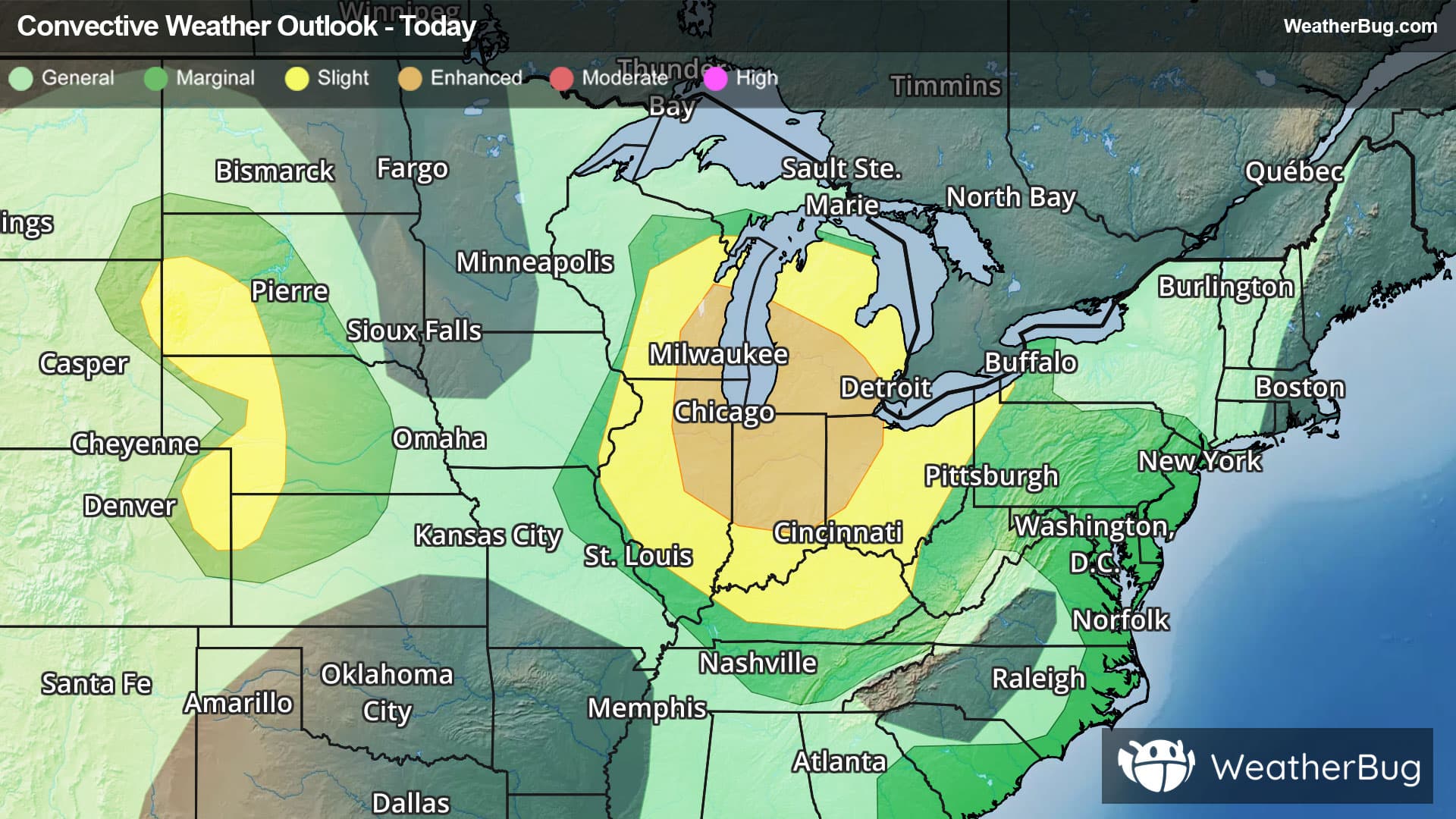
There is a Enhanced Severe Storm Risk for your location. Continue reading for today's outlook from the National Weather Service's Storm Prediction Center. -------------------- National Severe Storm Outlook THERE IS AN ENHANCED RISK OF SEVERE THUNDERSTORMS OVER PARTS OF THE LOWER GREAT LAKES AND MIDWEST STATES THERE IS A SLIGHT RISK OF SEVERE THUNDERSTORMS OVER PARTS OF THE CENTRAL AND NORTHERN HIGH PLAINS SUMMARY Severe storms capable of strong to severe wind gusts and large hail are expected across the Great Lakes and Midwest through tonight. More sporadic occurrences of damaging wind are possible in the Mid-Atlantic, Tennessee Valley, central High Plains, and southeast Arizona. 20z Update IL/IN An evolving convective cluster across northern IL/IN and southern lower MI should continue to move south/southeast this afternoon. Low-level convergence is maximized along a weak CAPE/ThetaE gradient laying roughly near the IN/OH border. CAM guidance and observation trends suggest this may provide a focus for convection through this afternoon and evening gradually turning the cluster further southward. Moderate buoyancy and 40+ kt of deep-layer shear parallel to the boundary could support organized linear/bowing structures with severe/damaging gusts and perhaps some QLCS tornadoes possible across northern IN and possibly extending into western OH. However, leading stratiform and cloud cover could limit the eastern extent of the higher severe risk, and confidence in the convective evolution is very low. Additional development has been noted along the western flank of the complex over northern IL, with another cluster of storms exiting southern WI. It is possible that these new storms, and additional ascent tied to a westerly low-level jet will support a second cluster of severe storms eventually organizing and moving more south across IL/IN. Hot surface temperatures (90-95 F) and a very large reservoir of extreme buoyancy (MUCAPE 4000-5000 J/kg) extending into IL and western IN would support a risk for widespread severe/damaging gusts. Given the increased confidence in damaging winds this afternoon/evening, have shifted 30% wind probabilities farther south in IN. Central and northern High Plains Scattered storms ongoing over the high plains should increase in coverage and intensity this afternoon. Steep mid-level lapse rates could promote severe wind gusts with stronger downdrafts, along with isolated hail. Minimal changes were made to the prior outlook, see MCD#1767 and MCD#1768 for more information. Additional scattered thunderstorms are ongoing over parts of the Mid Atlantic/Southeast and southern AZ. These storms should continue this afternoon with potential for sporadic damaging gusts owing to heavy water loading and moderate buoyancy. Limited vertical shear and only modest clustering suggest severe potential will remain isolated before diminishing overnight.