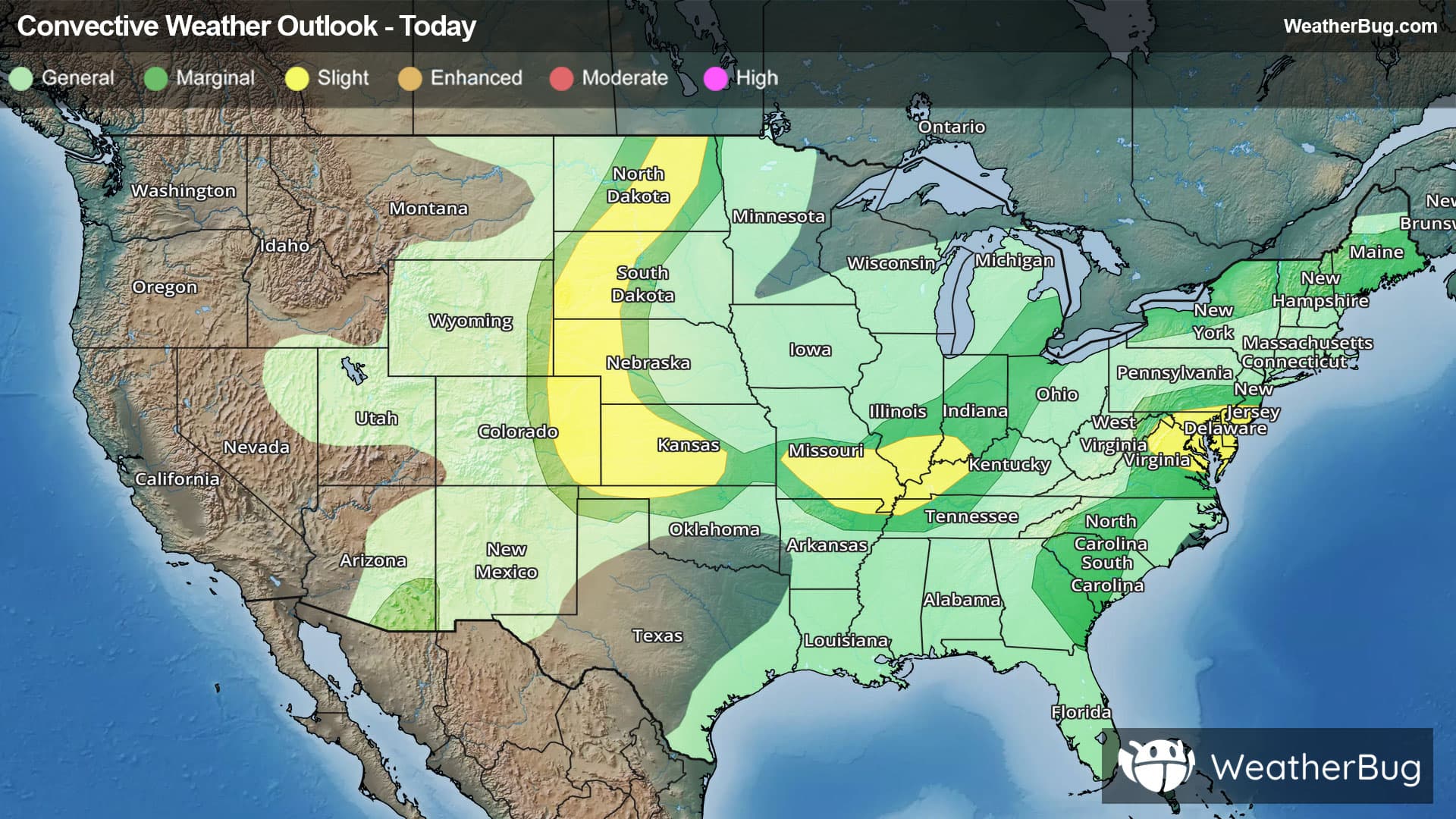
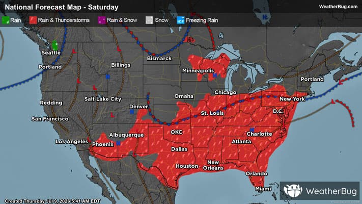
Weather Alerts For Hawaii Volcanoes National Park, HI
Flash Flood Warning
-BULLETIN - EAS ACTIVATION REQUESTED Flash Flood Warning National Weather Service Honolulu HI 1207 AM HST Sat Mar 14 2026 The National Weather Service in Honolulu has extended the * Flash Flood Warning for... The island of Hawaii in Hawaii County * Until 400 AM HST. * At 1207 AM HST, radar indicated heavy rain continued to impact the Puna and Kau Districts along the southeast slopes of the Big Island. Rain was falling at a rate of 1 to 2 inches per hour. Additionally, Emergency Management reported that Wood Valley Road remains closed in both directions due to flooding. HAZARD...Flash flooding caused by heavy rain. SOURCE...Radar. IMPACT...Flooding in drainages, streams, rivers, roads, properties, and other low-lying areas. Public road closures possible in some areas. Landslides are possible in steep terrain. * Some locations that will experience flash flooding include... Hawaiian Paradise Park, Hawaii Volcanoes National Park, Wood Valley, Pahala, Volcano, Glenwood, Punaluu Beach, Kawa Flats, Mountain View, Naalehu, Hawaiian Acres, Orchidlands Estates, Keaau, Pahoa, Hawaiian Ocean View, Fern Forest, Eden Roc, Fern Acres and Waiohinu. PRECAUTIONARY/PREPAREDNESS ACTIONS... Stay away from streams, rivers, drainage ditches, and culverts, even if they are currently dry. Be especially cautious at night when it is harder to recognize the dangers of flooding. && This warning may need to be extended beyond 400 AM HST if flooding persists.
Flood Watch
-Flood Watch National Weather Service Honolulu HI 1005 PM HST Fri Mar 13 2026 ...FLOOD WATCH FOR KAUAI THROUGH SATURDAY AFTERNOON... ...FLOOD WATCH FOR OAHU THROUGH SATURDAY NIGHT... ...FLOOD WATCH FOR MAUI COUNTY AND THE BIG ISLAND THROUGH SUNDAY NIGHT... Kona-Kohala-Big Island Interior-Big Island South-Big Island Southeast-Big Island East-Big Island North- 1005 PM HST Fri Mar 13 2026 * WHAT...Flash flooding caused by excessive rainfall is possible. * WHERE...The Big Island. * WHEN...Through late Sunday night. * IMPACTS...Significant flooding may occur due to the overflow of streams and drainages. Roads in several areas may be closed, along with property damage in urban or low lying spots due to runoff. Landslides may also occur in areas with steep terrain. * ADDITIONAL DETAILS... - Considerable flash flooding is possible beginning later today as a large and powerful kona storm northwest of the state draws deep tropical moisture northward across the islands. Persistent bands of heavy rain and thunderstorms may produce intense rainfall rates, leading to rapid rises in streams and flooding of roads and low lying areas. PRECAUTIONARY/PREPAREDNESS ACTIONS... You should monitor later forecasts and be prepared to take action should Flash Flood Warnings be issued. &&
High Surf Advisory
-Coastal Hazard Message National Weather Service Honolulu HI 858 PM HST Fri Mar 13 2026 ...HIGH SURF ADVISORY SOUTH FACING SHORES... .Gale force southerly winds will create large and rough surf along south facing shores through Saturday afternoon. Niihau-Kauai Southwest-Waianae Coast-Kahoolawe-Maui Leeward West- Kona-Kohala-Kauai South-East Honolulu-Honolulu Metro-Ewa Plain- Molokai West-Molokai Leeward South-Lanai Leeward-Lanai South- Maui Central Valley South-South Maui/Upcountry-South Haleakala- Big Island South-Big Island Southeast- 858 PM HST Fri Mar 13 2026 ...HIGH SURF ADVISORY IN EFFECT UNTIL 6 PM HST SATURDAY... * WHAT...Large breaking waves of 8 to 12 feet. * WHERE...South facing shores of Kahoolawe, Kauai, Lanai, Maui, Molokai, Niihau, Oahu and the Big Island. * WHEN...Until 6 PM HST Saturday. * IMPACTS...Moderate. Strong breaking waves and strong currents will make swimming dangerous. PRECAUTIONARY/PREPAREDNESS ACTIONS... Heed all advice from ocean safety officials. When in doubt, don't go out. &&
High Wind Warning
-URGENT - WEATHER MESSAGE National Weather Service Honolulu HI 113 PM HST Fri Mar 13 2026 Kona-Kohala-Big Island Interior-Big Island South-Big Island Southeast-Big Island East-Big Island North- 113 PM HST Fri Mar 13 2026 ...HIGH WIND WARNING IN EFFECT UNTIL 6 AM HST SUNDAY BIG ISLAND LOWER ELEVATIONS... * WHAT...Southwest winds increasing this afternoon to 30 to 40 mph with gusts up to 60 mph Big Island lower elevations. * WHERE...Island wide strong gusty winds are possible, but areas most at risk are communities north and east of steep mountains including Kona and Kau Districts. * WHEN...Until 6 AM HST Sunday. * IMPACTS...Damaging winds may blow down trees and power lines and damage roofs. Power outages are possible. Travel will be difficult, especially for high profile vehicles. PRECAUTIONARY/PREPAREDNESS ACTIONS... Strong winds may lead to property damage. Hazardous driving conditions due to powerful cross winds will pose a serious risk for drivers, especially for light weight and high profile vehicles. Loose outdoor items should be brought inside or secured properly. &&