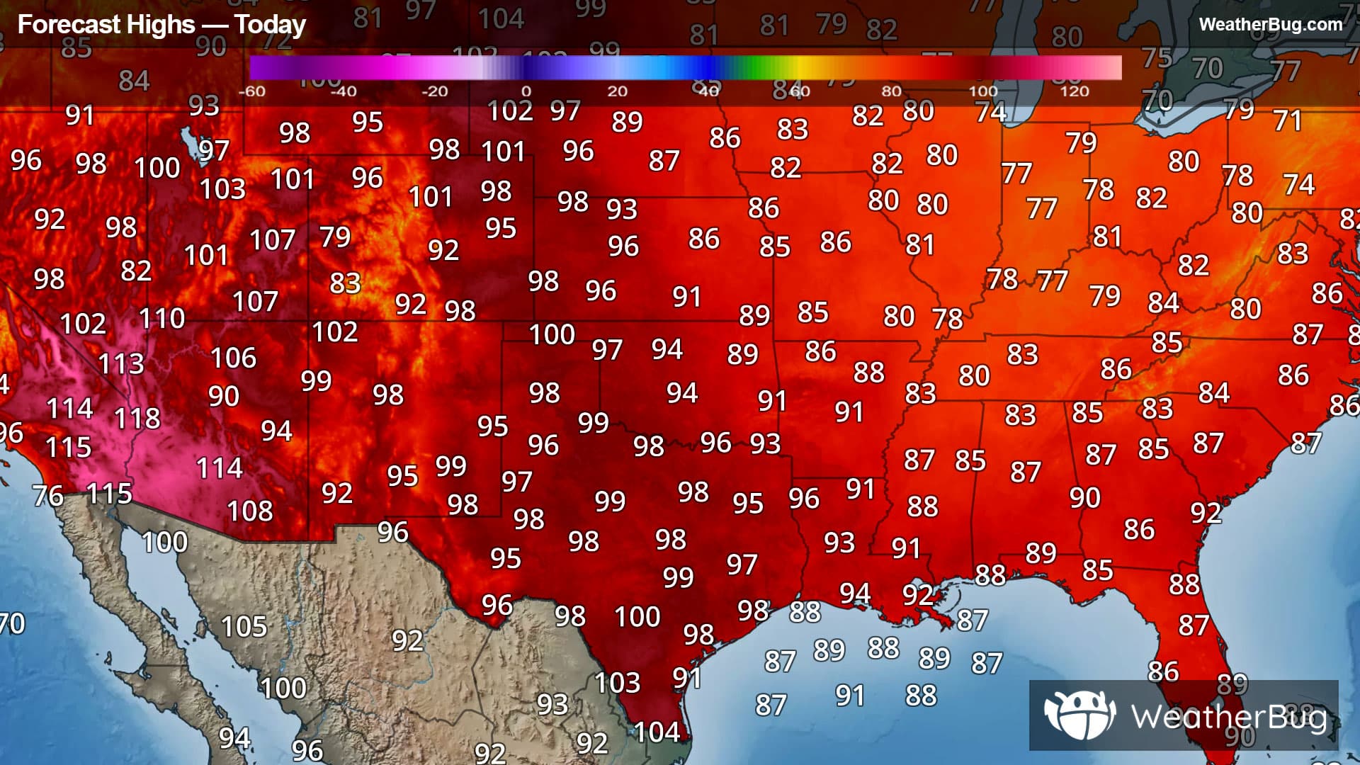
Blistering Heat for Many West of the Mississippi
Dangerous heat will continue across much of the West today.
Read More
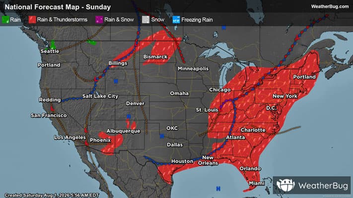
There is a Marginal Severe Storm Risk for your location. Continue reading for today's outlook from the National Weather Service's Storm Prediction Center. -------------------- National Severe Storm Outlook THERE IS A MARGINAL RISK OF SEVERE THUNDERSTORMS THIS AFTERNOON AD EVENING ACROSS THE LOWER GREAT LAKES/UPPER OHIO VALLEY INTO MIDDLE AND SOUTHERN ATLANTIC SEABOARD...AND TONIGHT ACROSS PARTS OF THE NORTHERN GREAT PLAINS SUMMARY Scattered strong thunderstorm development is likely this afternoon and evening across parts of the lower Great Lakes and upper Ohio Valley into the middle and southern Atlantic Piedmont. This may be accompanied by some risk for severe weather, mainly in the form of localized damaging wind gusts. Discussion Models indicate that one notable short wave perturbation within the westerlies will progress east of the Canadian Rockies through much of the Canadian Prairies by early Monday. As this occurs, it appears that an associated surface cyclone will occlude over northern portions of the Prairies during the day today, with one trailing cold front advancing east of the northern U.S. Rockies before stalling/weakening across the adjacent high plains, as another more substantive cold front approaches the western through central Canadian/U.S. border. At the same time, a trailing mid-level short wave trough is forecast to dig inland of the Pacific Northwest, then turn eastward across the northern U.S. intermountain region into Rockies. As it does, it appears that it will contribute to at least some suppression of initially more prominent mid-level ridging centered over the Southwest. Downstream, larger-scale mid-level troughing is likely to be maintained east of the Mississippi Valley through the Atlantic Seaboard. However, the most prominent embedded short wave trough already appears to be in the process of becoming increasingly sheared across the lower Ohio Valley. This is forecast to continue while shifting eastward toward the Appalachians today through tonight, with perhaps one emerging perturbation consolidating with another digging impulse across the lower Great Lakes vicinity later today through tonight. This may be accompanied by a northeastward migrating surface low, trailed by a weak cold frontal slowly advancing into and across the Appalachians. Eastern U.S To the east of the larger-scale mid-level trough axis, early day cloud cover, precipitation, and otherwise generally weak lower/mid-tropospheric lapse rates will probably tend to at least slow, if not inhibit, boundary-layer destabilization. However, convection-allowing guidance suggests that breaks in cloud cover will eventually allow for widely scattered to scattered intensifying thunderstorm development by late this afternoon, if not earlier. It appears that this may tend to focus within a pre-cold frontal corridor across the Allegheny Plateau/upper Ohio Valley into lower Great Lakes vicinity, where it could be enhanced by 20-40 kt south-southwesterly flow in the 850-500 mb layer, and within somewhat more modest flow off the higher terrain into lee surface troughing across the Piedmont. Given at least modest CAPE in excess of 1000 J/kg, and potential for heavy precipitation loading in the presence of seasonably high moisture content, localized strong downbursts may generate a few damaging surface gusts. Within the better shear across the Allegheny Plateau into lower Great Lakes vicinity, the evolution of transient supercell structures accompanied by some risk for a tornado does not appear entirely out of the question, given forecast surface dew points near/above 70F. However, this potential remains unclear, based on varied model guidance. North Dakota Some model output suggests that there may be at least attempts at deep convective development late this afternoon near the weak pre-cold frontal surface troughing. However, the potential for sustained thunderstorm activity remains more unclear due to limited low-level moisture beneath very warm and dry mid-levels, associated with an elevated mixed-layer overspreading the region during the day. It appears that somewhat better potential for thunderstorm development may await increasing forcing for ascent with the approach of the upstream short wave trough by late tonight. Based on forecast soundings this probably will be elevated or high-based in nature, but perhaps accompanied by some risk for hail and/or gusty winds.