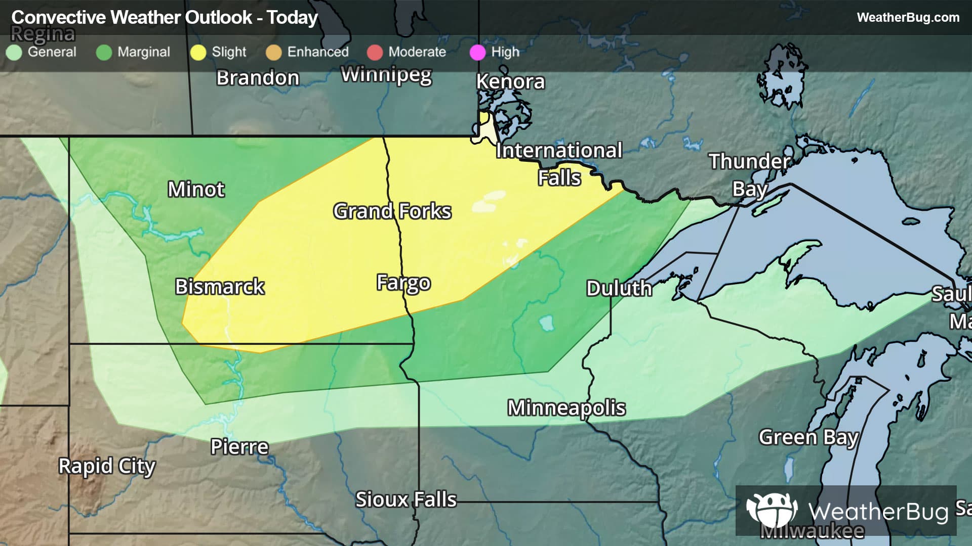
Weather Alerts For Kingman, IN
Severe Storm Risk
-There is a Marginal Severe Storm Risk for your location. Continue reading for today's outlook from the National Weather Service's Storm Prediction Center. -------------------- National Severe Storm Outlook THERE IS AN ENHANCED RISK OF SEVERE THUNDERSTORMS ACROSS PARTS OF FAR NORTHERN OKLAHOMA...SOUTHERN AND EASTERN KANSAS INTO NORTHWEST MISSOURI...FAR SOUTHEAST NEBRASKA AND SOUTH-CENTRAL IOWA SUMMARY Numerous severe thunderstorms are expected this evening from the southern and central Plains into the mid Missouri Valley. Supercells and bowing line segments capable of producing severe wind gusts, tornadoes and large hail remain likely from eastern and southern Kansas into far southeast Nebraska, Iowa and northwest Missouri. Southern and Central Plains/Mid Missouri Valley At the synoptic level, multiple shortwave troughs are ejecting northeastward across the central U.S. early this evening. A 50 to 70 knot mid-level jet is translating northeastward across the central Plains, with a 40 to 50 knot low-level jet in place from northern Oklahoma into eastern Kansas and western Missouri. A squall-line is ongoing along the western edge of the low-level jet, and this line will move east-southeastward across the remainder of eastern Kansas into western Missouri this evening into tonight. Ahead of the line, strong instability is analyzed by the RAP with MLCAPE in the 3000 to 4000 J/kg range. This, combined with strong large-scale ascent to the southeast of the mid-level jet, and moderate deep-layer shear evident on regional WSR-88D VWPs, will continue to support a severe threat with this line for the remainder of the evening. Severe wind gusts with be likely along the leading edge of the line. Large hail and tornadoes will also be possible with rotating elements embedded in the line. Further north-northeast into northeast Kansas, northwest Missouri and south-central Iowa, several semi-discrete supercells are ongoing. The Kansas City WSR-88D has 0-3 km storm-relative helicity near 475 ms/s2, which appears representative of the environment ahead of these storms. For this reason, a potential will continue for strong tornadoes over the next few hours. These supercells will also be capable of producing large hail and severe wind gusts. The squall-line will gradually move east-southeastward into the lower Missouri Valley and Ozarks from late this evening into the overnight period. The severe threat will become less widespread as relatively weaker instability is encountered later tonight. Southern Plains At the surface, a 997 mb low is located over far northwestern Oklahoma, with a dryline extending southward across far western Oklahoma into west Texas. To the east of the dryline, the RAP has MLCAPE in the 3000 to 4000 J/kg range. Near the axis of the strongest instability, a few storms are ongoing across southwest Oklahoma, but weakening has recently occurred. Redevelopment will be possible later this evening. The strong instability combined with moderate deep-layer shear and steep low to mid-level lapse rates would support a threat for large hail and severe wind gusts, if cells can re-intensify. An isolated tornado threat will also be possible if a supercell could develop. Thunderstorms are expected to increase in coverage over much of Oklahoma during the overnight period, as a cold front moves southward. However, the severe threat should become more isolated tonight as instability gradually decreases across the region.
Pollen Alert
-Pollen Index: 9.4 Pollen Level: medium-high Predominant Pollen: Birch, Maple and Ash. The amount of pollen in the air for Tuesday will be falling in the moderate range. This decrease is due to falling temperatures, rising humidity and heavy rains in the evening which tend to wash pollen out of the air. With this amount of reduction in pollen levels, tomorrow should be better for allergy sufferers.