Dangerous Storms Set to Rumble Over the Plains
As has been the case the past several days, strong to severe thunderstorms will form across parts of the northern and central Plains this afternoon and tonight.
Read More
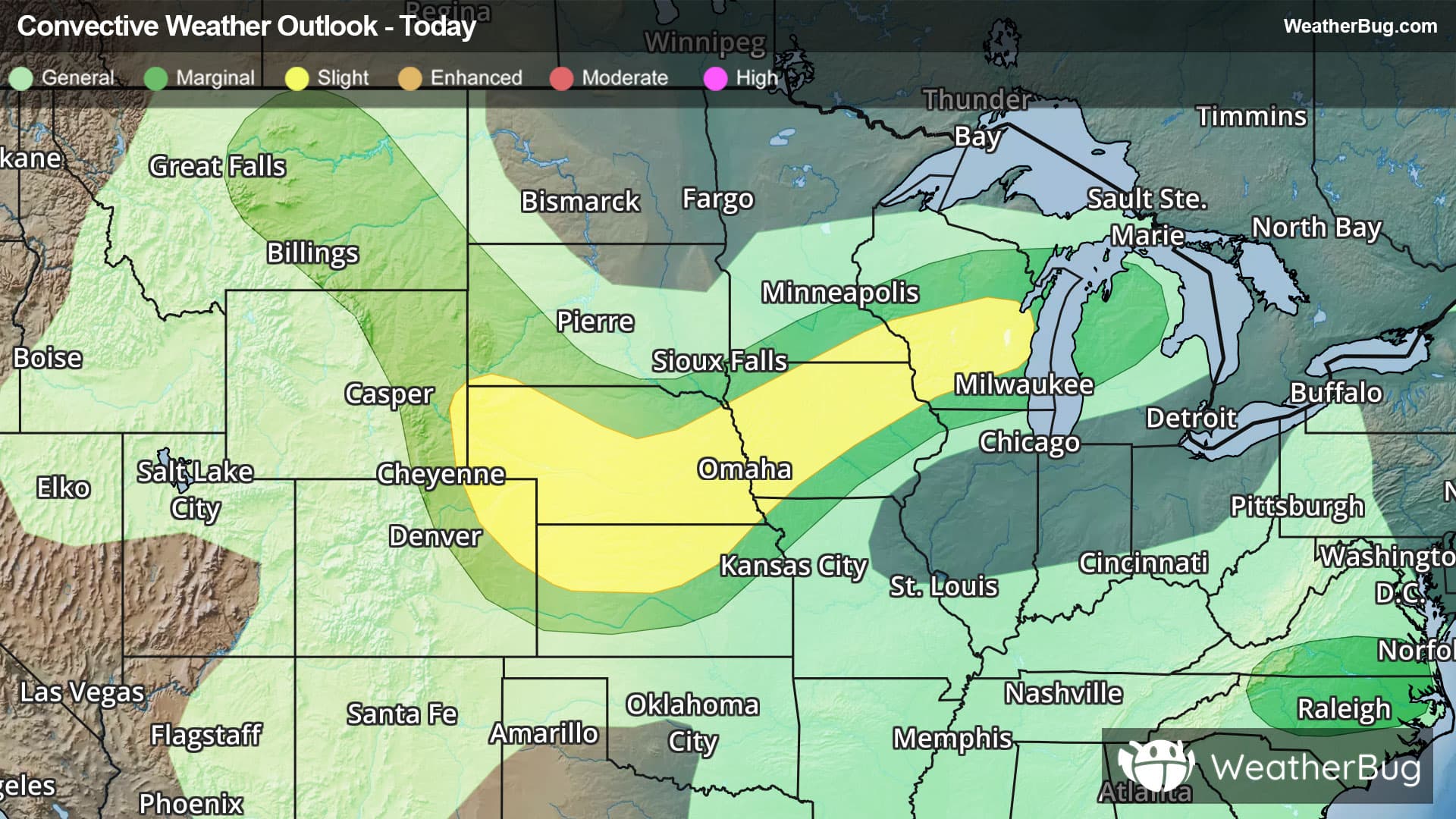
There is a Marginal Severe Storm Risk for your location. Continue reading for today's outlook from the National Weather Service's Storm Prediction Center. -------------------- National Severe Storm Outlook THERE IS AN ENHANCED RISK OF SEVERE THUNDERSTORMS ACROSS NORTHEAST COLORADO...FAR SOUTHWEST NEBRASKA...AND NORTHWEST KANSAS SUMMARY Thunderstorms with severe wind gusts and hail will be possible this afternoon and evening across parts of the central Plains, and from the Missouri Valley into the upper Mississippi Valley. Isolated severe gusts may also occur from the northern Great Basin into the northern High Plains and from North Carolina into southern Virginia. Central High Plains across the central Plains and Mid MO Valley into the Upper Midwest Early-morning surface analysis reveals a cold front extending southwestward from north-central MN to a low southeast SD, where the front then becomes oriented more westerly across southern SD before arcing back northwestward across northeast WY and central MT. This front is expected to make gradual southward/southeastward progress today, before becoming more diffuse under the influence of storm outflow late in the period. Ample low-level moisture will be place ahead of this front by the late afternoon, with dewpoints likely ranging from the low/mid 60s across central NE into the upper 60s/low 70s across northern IA, southern MN, and northern WI. The strongest buoyancy is expected from eastern NE into western/northwestern IA, where the best overlap between the higher surface dewpoints and the eastern extent of the steep mid-level lapse rates exists. Thunderstorm development is expected first from the eastern/northeastern IA into the Upper Midwest, where convergence along the front will be augmented by large-scale ascent attendant to an approaching low-amplitude shortwave trough. A few stronger updrafts are possible in this region, but more modest buoyancy should limit updraft persistence, with a quick trend towards a more outflow-dominant storm mode. Stronger buoyancy will support more robust updrafts from central IA western into central NE, although modest deep-layer vertical shear should limit organization in this area as well. Stronger updrafts could contribute to stronger downdrafts, as well as isolated hail, with a slightly higher overall severe potential here than areas farther northeast. A somewhat separate regime is anticipated farther west across the central High Plains. Here, moist, post-frontal, upslope flow will result in moderate buoyancy across the NE Panhandle into eastern WY, supporting airmass destabilization and late afternoon thunderstorm development. Moderate to strong deep-layer vertical shear, resulting from easterly low-level flow beneath moderate northwesterly flow aloft, is anticipated over this region as well. An initially cellular mode is likely, with some large hail possible, with fairly quick upscale growth likely. High cloud bases atop a warm and deeply mixed boundary layer will support strong outflow, which, when combined with the strong deep-layer shear, could result in one or more organized bowing segments. These two regimes come together across south-central NE/north-central KS overnight, amid a strengthen low-level jet, but predictability on the overall convective evolution is limited. Seemingly some severe potential could linger across south-central/southeast NE into north-central/northeast KS overnight. Northern Great Basin into the northern Rockies A low-amplitude shortwave trough is forecast to progress through the northern periphery of the upper ridging in place over the Four Corners vicinity. Mid-level moisture associated with this wave coupled with strong heating will result in airmass destabilization and the development of widely scattered to scattered thunderstorms. High storm bases atop a deeply mixed boundary layer will support the potential for damaging gusts with the stronger storms. Southern AZ Increased mid-level moisture will support thunderstorm development across the higher terrain of eastern AZ during the afternoon. Westward drift of the upper ridge will result in modest easterly mid-level flow over the region, with some potential for the thunderstorms to progress westward into the lower elevations during the late afternoon. A few strong gusts are possible but uncertainty regarding coverage precludes introducing any probabilities with this outlook.


