Weather Alerts For Montgomeryville, PA
Nearby Flash Flood Warning
-A Weather Alert has been issued for a nearby area. While your current location is outside of the impacted area, please stay alert and monitor weather conditions. # SUMMARY -------------------- The National Weather Service in Mount Holly has issued a - Flash Flood Warning for... Northeastern New Castle County in northern Delaware... Northwestern Burlington County in southern New Jersey... Northwestern Camden County in southern New Jersey... Northwestern Gloucester County in southern New Jersey... Northwestern Salem County in southern New Jersey... Southeastern Chester County in southeastern Pennsylvania... Delaware County in southeastern Pennsylvania... Southeastern Montgomery County in southeastern Pennsylvania... Philadelphia County in southeastern Pennsylvania... - Until 300 AM EDT. - At 1100 PM EDT, Doppler radar indicated thunderstorms producing heavy rain across the warned area. Between 0.5 and 1.5 inches of rain have fallen. Additional rainfall amounts of 1 to 2 inches are possible in the warned area. Flash flooding is ongoing or expected to begin shortly. # DETAILS -------------------- HAZARD Life threatening flash flooding caused by thunderstorms. SOURCE Radar. IMPACT Life threatening flash flooding of creeks and streams, urban areas, highways, streets, and underpasses. SOME LOCATIONS THAT MAY EXPERIENCE FLASH FLOODING INCLUDE - Philadelphia, Camden, Wilmington, West Chester, Gloucester City, Cherry Hill, Mount Laurel, Norristown, Chester, Willingboro, Deptford and West Deptford. - People attending Lemon Hill should seek shelter immediately. THIS INCLUDES THE FOLLOWING HIGHWAYS Interstate 295 in New Jersey between mile markers 0 and 47. Interstate 476 in Pennsylvania between mile markers 0 and 19. New Jersey Turnpike between exits 1 and 5. Interstate 76 in Pennsylvania between mile markers 329 and 351. Interstate 95 in Pennsylvania between mile markers 0 and 33. Interstate 676 in Pennsylvania between mile markers 0 and 1. Interstate 676 in New Jersey between mile markers 0 and 4. Northeast Extension near mile marker 21. Interstate 76 in New Jersey between mile markers 0 and 3. Pennsylvania Turnpike between mile markers 329 and 346. Interstate 95 in Delaware between mile markers 9 and 23. ISSUED AT Sunday, July 5, 2026 at 11:00 PM EDT ISSUED BY National Weather Service Mount Holly NJ HEADER BULLETIN - EAS ACTIVATION REQUESTED | Flash Flood Warning # PRECAUTIONARY/PREPAREDNESS ACTIONS -------------------- Turn around...don't drown when encountering flooded roads. Most flood deaths occur in vehicles. Be especially cautious at night when it is harder to recognize the dangers of flooding.
Nearby Severe Thunderstorm Warning
-A Weather Alert has been issued for a nearby area. While your current location is outside of the impacted area, please stay alert and monitor weather conditions. # HEADLINE -------------------- A SEVERE THUNDERSTORM WARNING REMAINS IN EFFECT UNTIL 1115 PM EDT FOR NEW CASTLE, NORTHERN KENT, NORTHWESTERN CUMBERLAND, SALEM, NORTHWESTERN GLOUCESTER, SOUTH CENTRAL MONTGOMERY, CENTRAL CHESTER AND DELAWARE COUNTIES # SUMMARY -------------------- At 1051 PM EDT, severe thunderstorms were located along a line extending from near Coatesville to New Castle to Smyrna, moving east at 35 mph. # DETAILS -------------------- HAZARD 60 mph wind gusts. SOURCE Radar indicated. IMPACT Damage to roofs, siding, trees, and power lines is possible. LOCATIONS IMPACTED INCLUDE Wilmington, Newark, Bridgeton, Middletown, West Chester, Chester, Phoenixville, West Norriton, Pennsville, Coatesville, Westtown, Smyrna, Carneys Point, Downingtown, Swarthmore, Elsmere, Kennett Square, New Castle, Penns Grove, and Salem. THIS INCLUDES THE FOLLOWING HIGHWAYS New Jersey Turnpike between exits 1 and 2. Pennsylvania Turnpike between mile markers 308 and 326. Interstate 95 in Pennsylvania between mile markers 0 and 9. Interstate 95 in Delaware between mile markers 5 and 23. Interstate 76 in Pennsylvania near mile marker 327. Interstate 295 in New Jersey between mile markers 0 and 17. Interstate 476 in Pennsylvania between mile markers 0 and 8, and near mile marker 11. ISSUED AT Sunday, July 5, 2026 at 10:52 PM EDT ISSUED BY National Weather Service Mount Holly NJ HEADER Severe Weather Statement # PRECAUTIONARY/PREPAREDNESS ACTIONS -------------------- For your protection move to an interior room on the lowest floor of a building. To report severe weather contact your nearest law enforcement agency. They will send your report to the National Weather Service office in Mount Holly NJ. Torrential rainfall is occurring with these storms, and may lead to flash flooding. Do not drive your vehicle through flooded roadways. # AREAS AFFECTED -------------------- Montgomery PA, Chester PA, Cumberland NJ, Delaware PA, Gloucester NJ, Kent DE, New Castle DE, Salem NJ
Severe Thunderstorm Watch
-# SUMMARY -------------------- THE NATIONAL WEATHER SERVICE HAS ISSUED SEVERE THUNDERSTORM WATCH 465 IN EFFECT UNTIL 1 AM EDT MONDAY FOR THE FOLLOWING AREAS IN DELAWARE THIS WATCH INCLUDES 3 COUNTIES IN CENTRAL DELAWARE KENT IN NORTHERN DELAWARE NEW CASTLE IN SOUTHERN DELAWARE SUSSEX IN MARYLAND THIS WATCH INCLUDES 4 COUNTIES IN NORTHEAST MARYLAND CAROLINE KENT QUEEN ANNE'S TALBOT IN NEW JERSEY THIS WATCH INCLUDES 7 COUNTIES IN SOUTHERN NEW JERSEY ATLANTIC BURLINGTON CAMDEN CAPE MAY CUMBERLAND GLOUCESTER SALEM IN PENNSYLVANIA THIS WATCH INCLUDES 7 COUNTIES IN EAST CENTRAL PENNSYLVANIA BERKS LEHIGH IN SOUTHEAST PENNSYLVANIA BUCKS CHESTER DELAWARE MONTGOMERY PHILADELPHIA THIS INCLUDES THE CITIES OF ALLENTOWN, ATLANTIC CITY, CAMDEN, CENTREVILLE, CHERRY HILL, CHESTERTOWN, DENTON, DEPTFORD, DOVER, DOYLESTOWN, EASTON, GEORGETOWN, GLASSBORO, HAMMONTON, MEDIA, MILLVILLE, MOORESTOWN, MOUNT HOLLY, NORRISTOWN, OCEAN CITY, PENNSVILLE, PHILADELPHIA, READING, WEST CHESTER, AND WILMINGTON. # DETAILS -------------------- ISSUED AT Sunday, July 5, 2026 at 6:48 PM EDT ISSUED BY NATIONAL WEATHER SERVICE MOUNT HOLLY NJ HEADER WATCH COUNTY NOTIFICATION FOR WATCH 465
Flood Watch
-# HEADLINE -------------------- FLOOD WATCH REMAINS IN EFFECT THROUGH MONDAY EVENING # DETAILS -------------------- WHAT Flash flooding caused by excessive rainfall continues to be possible. WHERE Portions of northern Delaware, including the following area, New Castle, New Jersey, including the following areas, Camden, Gloucester, Hunterdon, Mercer, Middlesex, Morris, Northwestern Burlington, Salem, Somerset, Sussex, Warren and Western Monmouth, and Pennsylvania, including the following areas, Berks, Carbon, Delaware, Eastern Chester, Eastern Montgomery, Lehigh, Lower Bucks, Monroe, Northampton, Philadelphia, Upper Bucks, Western Chester and Western Montgomery. WHEN Through Monday evening. IMPACTS Excessive runoff may result in flooding of rivers, creeks, streams, and other low-lying and flood-prone locations. Creeks and streams may rise out of their banks. Flooding may occur in poor drainage and urban areas. ADDITIONAL DETAILS - Multiple rounds of heavy showers and thunderstorms are expected to impact the area this afternoon through Monday. Rain amounts of over 2 inches in an hour will be possible leading to areas of flash flooding. - http://www.weather.gov/safety/flood ISSUED AT Sunday, July 5, 2026 at 3:15 PM EDT ISSUED BY National Weather Service Mount Holly NJ HEADER URGENT - IMMEDIATE BROADCAST REQUESTED | Flood Watch # PRECAUTIONARY/PREPAREDNESS ACTIONS -------------------- You should monitor later forecasts and be prepared to take action should Flash Flood Warnings be issued. # AREAS AFFECTED -------------------- Eastern Montgomery, Philadelphia, Western Monmouth, Berks, Camden, Carbon, Delaware, Eastern Chester, Gloucester, Hunterdon, Lehigh, Lower Bucks, Mercer, Middlesex, Monroe, Morris, New Castle, Northampton, Northwestern Burlington, Salem, Somerset, Sussex, Upper Bucks, Warren, Western Chester, Western Montgomery Including the cities of Allentown, Media, Pottstown, Somerville, Camden, Lansdale, Cherry Hill, Philadelphia, Morrisville, Bethlehem, West Chester, Morristown, Perkasie, Moorestown, Norristown, Glassboro, Trenton, Jim Thorpe, Doylestown, Freehold, Washington, Flemington, Honey Brook, Chalfont, Pennsville, Newton, New Brunswick, Easton, Reading, Kennett Square, Collegeville, Wilmington, Oxford, Stroudsburg, and Mount Holly
Air Quality Alert
-# HEADLINE -------------------- AIR QUALITY ALERT IS IN EFFECT FOR SUNDAY JULY 5 # SUMMARY -------------------- The Delaware Valley Regional Planning Commission has issued a code orange air quality alert Sunday for The Philadelphia Metro area. A code orange air quality alert means that air pollution concentrations within the region may become unhealthy for sensitive groups. Sensitive groups include children...people suffering from asthma... heart disease or other lung diseases...and the elderly. The effects of air pollution can be minimized by avoiding strenuous activity or exercise outdoors. For more information on ground-level ozone and fine particles...visit http://www.phila.gov/health/units/ams/ # DETAILS -------------------- ISSUED AT Saturday, July 4, 2026 at 3:45 PM EDT ISSUED BY Relayed by National Weather Service Mount Holly NJ HEADER Air Quality Alert Message | MD Dept of Environment, DE Dept of Natural Resources and | Environmental Control, NJ Dept of Environmental Protection, PA | Dept of Environmental Protection and Delaware Valley Regional | Planning Commission # AREAS AFFECTED -------------------- Delaware, Eastern Chester, Eastern Montgomery, Lower Bucks, Philadelphia, Upper Bucks, Western Chester, Western Montgomery
Lightning Alert
-Closest strike: 2.13 miles Stay Alert! Remain in a safe area until there has been no lightning within 10 miles of this location for 30 minutes. Please be aware that lightning activity can remain high even when a storm is moving away from your location. Even if rain has stopped, do not leave your safe area until WeatherBug indicates that lightning is more than 10 miles away from this selected location. IF OUTDOORS Avoid water, high ground, and open spaces. Avoid all metal objects including electric wires, fences, and machinery. Find a safe area in a building or in a fully enclosed vehicle with the windows completely shut. Unsafe places include underneath canopies, small picnic or rain shelters, convertibles, or near trees. IF INDOORS Avoid water and stay away from doors and windows. Avoid using a hard line telephone. Take off headphones. Turn off, unplug, and stay away from appliances, computers, power tools, and TV sets. Lightning may strike exterior electric and phone lines, inducing shocks to inside equipment.
Severe Storm Risk
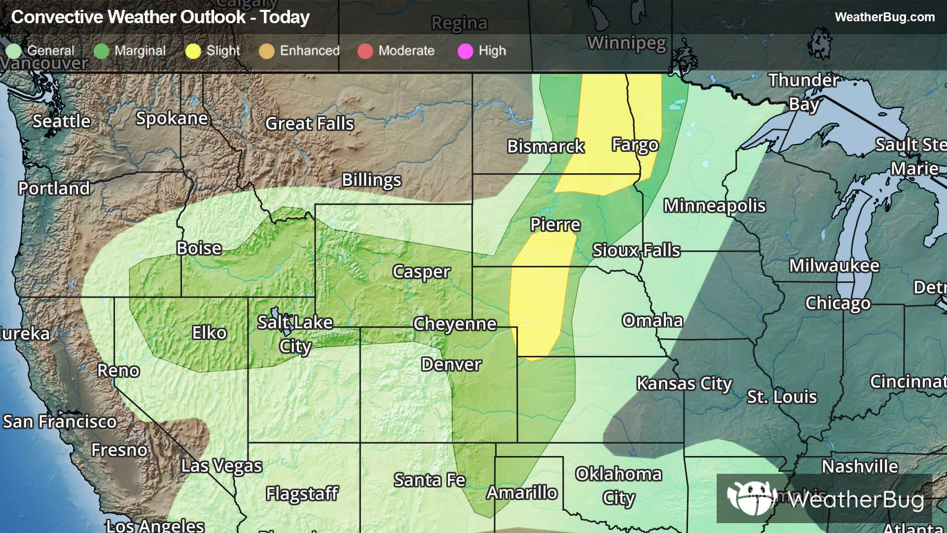
-There is a Slight Severe Storm Risk for your location. Continue reading for today's outlook from the National Weather Service's Storm Prediction Center. -------------------- National Severe Storm Outlook THERE IS A SLIGHT RISK OF SEVERE THUNDERSTORMS OVER WEST-CENTRAL TEXAS...WESTERN AND NORTH-CENTRAL NORTH DAKOTA...AND PARTS OF THE MID-ATLANTIC SUMMARY Scattered wind damage remains possible with thunderstorms across the Mid-Atlantic and west-central Texas through the remainder of the evening. Large hail and damaging gusts may still occur with thunderstorms in North Dakota and Montana. West-Central Texas A forward-propagating MCS has evolved this evening across the TX Big Country into the Low Rolling Plains with gusts of 62 and 75 mph reported with the system over the past hour. The inflow air mass remains hot and relatively moist with latest objective analysis indicating MLCAPE of 1500-2000 J/kg. The KFDR VWP indicates a belt of 30-40 kt northerly winds in the 4-6 km AGL layer, which is likely enhancing vertical shear. This, when coupled with the presence of a relatively deep and well-mixed PBL, will continue to support severe wind gusts and sporadic hail occurrences for the next few hours as the MCS continues south into the Concho Valley. For additional near-term details, see MCD 1517. Mid-Atlantic Earlier, more discrete storms have gradually evolved into a larger-scale complex over southeast PA with that system tracking east along a subtle boundary that extends into central NJ. Additional storm clustering is noted farther south, near Baltimore, with latest model guidance suggesting additional consolidation of storms over the next hour or two across the Delmarva into the DE River Valley. The 00Z IAD sampled a moist and moderately unstable air mass, which featured steep lapse rates in the lowest 1-1.5 km AGL. While vertical shear is relatively weak, the steep lapse rates will support episodic cold-pool organization with an attendant risk for damaging winds for the next 1-3 hours. For additional near-term information, see MCD 1518. Montana and North Dakota Mesoanalysis places a surface front from western ND into south-central MT, with steep lapse rates and locally higher boundary-layer moisture contributing to a corridor of moderate to strong instability in the vicinity of the boundary over northwest ND into northeast MT. Widely scattered thunderstorms are ongoing this evening to the east of the boundary in western ND amidst a warmer and slightly drier boundary layer as sampled by the 00Z BIS sounding. The development of a nocturnal low-level jet may support some moistening late this evening into tonight; however, increasing convective inhibition may become more prohibitive to surface-based storm sustenance upon nightfall. Nonetheless, isolated occurrences of large hail and severe wind gusts remain possible with the ongoing storms for the next 1-3 hours. Farther west, a separate thunderstorm regime is ongoing to the north of the surface front in central MT. The short-term models suggest a few of those storms could persist through the remainder of the evening with isolated occurrences of large hail and severe wind gusts possible.