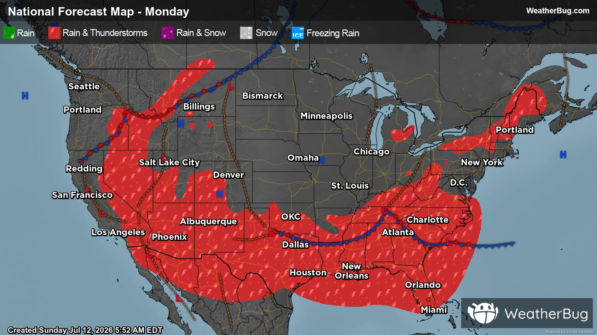
Weather Alerts For Peace Valley, MO
Wind Advisory
-URGENT - WEATHER MESSAGE National Weather Service Springfield MO 953 AM CST Sun Dec 28 2025 Bourbon-Crawford-Cherokee-Benton-Morgan-Miller-Vernon-St. Clair- Hickory-Camden-Pulaski-Barton-Cedar-Polk-Dallas-Laclede-Texas- Jasper-Dade-Greene-Webster-Wright-Newton-Lawrence-Christian- Douglas-Howell-McDonald-Barry-Stone-Taney-Ozark- Including the cities of Stockton, Cole Camp, Charity, Springfield, Bolivar, Northview, Quincy, Roach, Foose, Rocky Comfort, Buffalo, Plad, Windyville, Branson, Madry, Goodman, Fort Leonard Wood, Sherwin, Monett, White Church, Kimberling City, Baxter Springs, El Dorado Springs, Pomona, Neutral, Marshfield, Anderson, Mansfield, Pineville, Stippville, Edmonson, Lowell, Nixa, Powersite, Pawnee Station, Stover, Osage Beach, Filley, Columbus, Noel, Vanzant, Decaturville, Camdenton, Graff, Lynchburg, Seymour, Huggins, Crane, Kenoma, South Fork, Hollister, Lone Oak, Hermitage, Ozark, Forsyth, Rocky Mount, Greenfield, Johnson City, Laurie, West Plains, Fort Scott, Mora, Plato, Dogwood, Lamar, Lake Ozark, Pottersville, Chicopee, Elsey, Roby, Marionville, Laquey, Crockerville, Nevada, Ozark Beach, March, Appleton City, Arnica, Caplinger Mills, Rome, Pittsburg, Aurora, Whitakerville, Eldon, Lockwood, Carthage, Cassville, Versailles, Lincoln, Mountain Grove, South West City, Riverton, Village of Four Seasons, Warsaw, Edgewater Beach, Joplin, Meinert, Squires, Tiffin, Rogersville, Wheatland, Selmore, Christian Center, Bendavis, Goodhope, Waynesville, Cross Timbers, Wasola, Olive, Silver Dollar City, Aurora Springs, Lebanon, Indian Point, Dawson, Kirbyville, Cedar Springs, Weaubleau, Neosho, Mount Vernon, Siloam Springs, Duncan, and Ava 953 AM CST Sun Dec 28 2025 ...WIND ADVISORY NOW IN EFFECT UNTIL 6 AM CST MONDAY... * WHAT...Northwest winds 15 to 25 mph with gusts up to 40 to 45 mph. * WHERE...Portions of southeast Kansas and central, south central, southwest, and west central Missouri. * WHEN...Until 6 AM CST Monday. * IMPACTS...Gusty winds will blow around unsecured objects. Tree limbs could be blown down and a few power outages may result. PRECAUTIONARY/PREPAREDNESS ACTIONS... Winds this strong can make driving difficult, especially for high profile vehicles. Use extra caution. Secure outdoor objects. &&
Severe Storm Risk
-There is a Marginal Severe Storm Risk for your location. Continue reading for today's outlook from the National Weather Service's Storm Prediction Center. -------------------- National Severe Storm Outlook THERE IS A SLIGHT RISK OF SEVERE THUNDERSTORMS ACROSS PARTS OF ILLINOIS...WESTERN KENTUCKY AND INDIANA SUMMARY Scattered severe thunderstorms are possible over parts of the Midwest and lower Ohio Valley this afternoon through the evening. Severe/damaging wind gusts and a couple of tornadoes are the primary threats. 20Z Update The only change to the outlook for this issuance is to trim the Marginal Risk area across parts of north-central Illinois behind a cold front that is moving southeastward across the region.