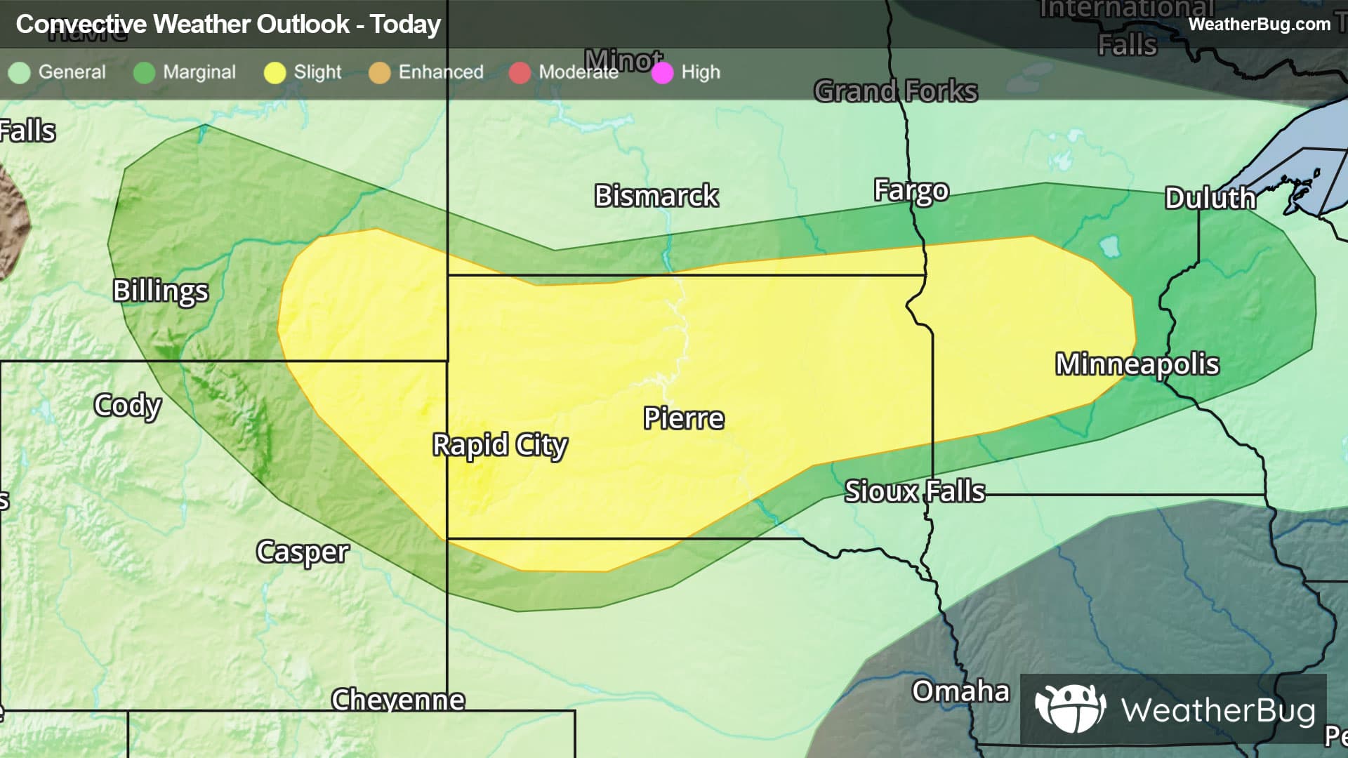
Weather Alerts For Sellersville, PA
Nearby Severe Thunderstorm Warning
-A Weather Alert has been issued for a nearby area. While your current location is outside of the impacted area, please stay alert and monitor weather conditions. BULLETIN - IMMEDIATE BROADCAST REQUESTED Severe Thunderstorm Warning National Weather Service Mount Holly NJ 251 PM EST Fri Dec 19 2025 The National Weather Service in Mount Holly NJ has issued a * Severe Thunderstorm Warning for... Ocean County in southern New Jersey... Camden County in southern New Jersey... Mercer County in central New Jersey... Somerset County in northern New Jersey... Northern Atlantic County in southern New Jersey... Southeastern Hunterdon County in northwestern New Jersey... Central Gloucester County in southern New Jersey... Burlington County in southern New Jersey... Monmouth County in central New Jersey... Middlesex County in northern New Jersey... East central Montgomery County in southeastern Pennsylvania... Southeastern Bucks County in southeastern Pennsylvania... Central Philadelphia County in southeastern Pennsylvania... * Until 345 PM EST. * At 251 PM EST, showers with damaging winds were located along a line extending from near New Hope to Turnersville, moving east at 50 mph. HAZARD...60 mph wind gusts. SOURCE...Radar indicated. IMPACT...Damage to roofs, siding, trees, and power lines is possible. * Locations impacted include... Philadelphia, Toms River, Trenton, Camden, New Brunswick, Perth Amboy, Long Branch, Asbury Park, Somerville, Gloucester City, Sandy Hook, Somerset, Edison, Lakewood, Cherry Hill, Middletown, Old Bridge, Bensalem, Jackson, and Howell. PRECAUTIONARY/PREPAREDNESS ACTIONS... For your protection move to an interior room on the lowest floor of a building. This severe thunderstorm may contain little or no lightning. Do not wait until you hear thunder before taking cover. &&
Severe Thunderstorm Warning
-BULLETIN - IMMEDIATE BROADCAST REQUESTED Severe Thunderstorm Warning National Weather Service Mount Holly NJ 241 PM EST Fri Dec 19 2025 The National Weather Service in Mount Holly NJ has issued a * Severe Thunderstorm Warning for... Morris County in northern New Jersey... Hunterdon County in northwestern New Jersey... Sussex County in northwestern New Jersey... Warren County in northwestern New Jersey... Northern Somerset County in northern New Jersey... East central Lehigh County in eastern Pennsylvania... East central Carbon County in northeastern Pennsylvania... Northwestern Bucks County in southeastern Pennsylvania... Monroe County in northeastern Pennsylvania... Northampton County in eastern Pennsylvania... * Until 345 PM EST. * At 241 PM EST, showers with damaging winds were located along a line extending from near Blakeslee to near Quakertown, moving northeast at 50 mph. HAZARD...60 mph wind gusts. SOURCE...Trained weather spotters. IMPACT...Damage to roofs, siding, trees, and power lines is possible. * Locations impacted include... Allentown, Easton, Morristown, Somerville, Newton, Montague, Mount Pocono, Bethlehem, Bridgewater, Dover, Madison, Hopatcong, Forks, Florham Park, East Hanover, Lincoln Park, Kinnelon, East Stroudsburg, Hackettstown, and Quakertown. PRECAUTIONARY/PREPAREDNESS ACTIONS... For your protection move to an interior room on the lowest floor of a building. These showers with damaging winds contain little or no lightning. Do not wait until you hear thunder before taking cover. &&
Wind Advisory
-URGENT - WEATHER MESSAGE National Weather Service Mount Holly NJ 1246 PM EST Fri Dec 19 2025 New Castle-Kent-Kent MD-Queen Annes-Talbot-Caroline-Warren-Morris- Hunterdon-Somerset-Middlesex-Mercer-Salem-Gloucester-Camden- Northwestern Burlington-Cumberland-Berks-Lehigh-Northampton- Delaware-Philadelphia-Western Chester-Eastern Chester-Western Montgomery-Eastern Montgomery-Upper Bucks-Lower Bucks- Including the cities of Norristown, Mount Holly, Reading, Pennsville, Kennett Square, Chalfont, Allentown, Camden, Perkasie, Easton, Collegeville, Millville, Morrisville, Washington, Chestertown, Cherry Hill, New Brunswick, Trenton, Honey Brook, Flemington, Pottstown, Oxford, Lansdale, Bethlehem, Somerville, Dover, Wilmington, Denton, Philadelphia, West Chester, Moorestown, Media, Glassboro, Morristown, Doylestown, and Centreville 1246 PM EST Fri Dec 19 2025 ...WIND ADVISORY REMAINS IN EFFECT UNTIL 1 AM EST SATURDAY... * WHAT...West winds 20 to 30 mph with gusts of 40 to 50 mph. * WHERE...Portions of central and northern Delaware, northeast Maryland, central, northern, northwest, and southern New Jersey, and east central and southeast Pennsylvania. * WHEN...Until 1 AM EST Saturday. * IMPACTS...Gusty winds will blow around unsecured objects. Tree limbs could be blown down and a few power outages may result. * ADDITIONAL DETAILS...The strongest winds are expected to occur during the second half of the afternoon into the early evening. PRECAUTIONARY/PREPAREDNESS ACTIONS... Winds this strong can make driving difficult, especially for high profile vehicles. Use extra caution. Secure outdoor objects. &&
Lightning Alert
-Closest strike: 10.41 miles Storms Approaching Stay alert and frequently check WeatherBug to see if storms are moving toward you. Be mindful that new storms can also form with little notice.