Severe Storms Fire Up Across The Great Lakes and Ohio Valley
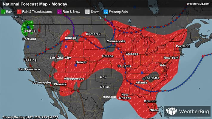
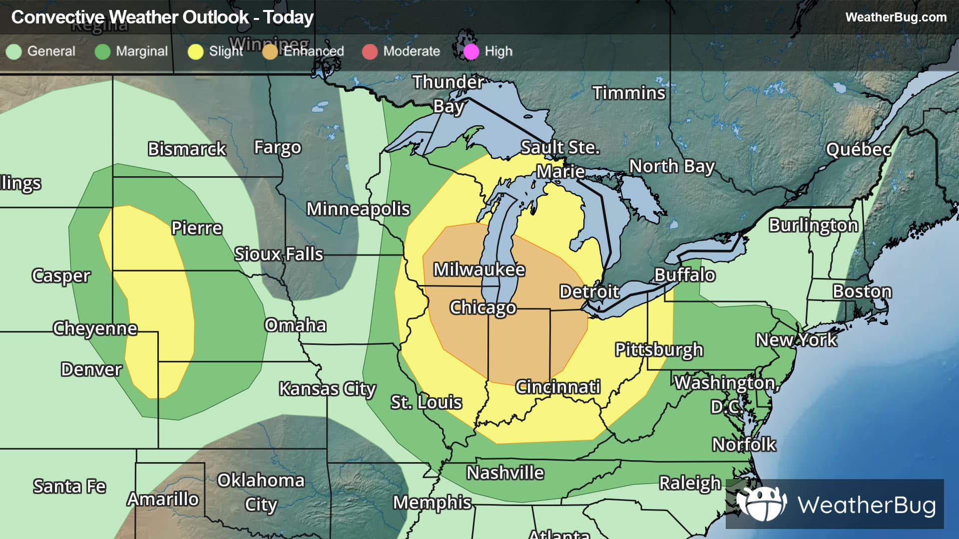
Strong to severe thunderstorms are expected to develop across the Great Lakes and Ohio Valley today.
Read More
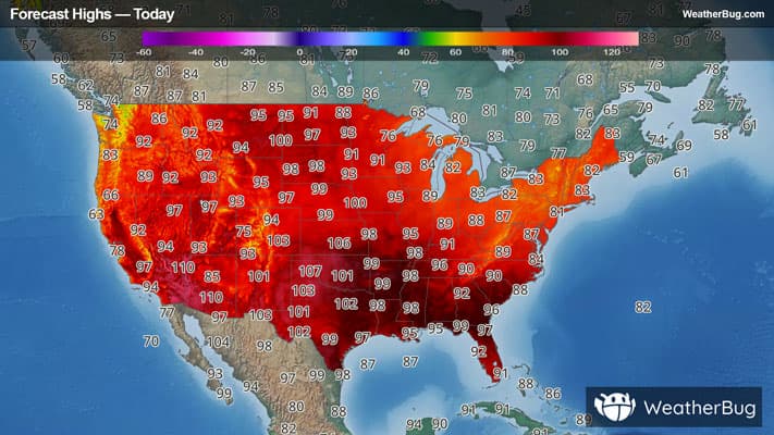
# HEADLINE -------------------- EXTREME HEAT WARNING REMAINS IN EFFECT UNTIL 10 PM CDT THIS EVENING # DETAILS -------------------- WHAT A dangerous combination of oppressively hot and humid conditions with heat index values between 105 to 115 expected. WHERE Portions of northwest and west central Illinois, east central, northeast, and southeast Iowa, and northeast Missouri. WHEN Until 10 PM CDT this evening. IMPACTS Heat related illnesses increase significantly during extreme heat and high humidity events. ISSUED AT Monday, July 27, 2026 at 7:54 AM CDT ISSUED BY National Weather Service Quad Cities IA IL HEADER URGENT - WEATHER MESSAGE # PRECAUTIONARY/PREPAREDNESS ACTIONS -------------------- Drink plenty of fluids, stay in an air-conditioned room, stay out of the sun, and check up on relatives and neighbors. Do not leave young children and pets in unattended vehicles. Car interiors will reach lethal temperatures in a matter of minutes. # AREAS AFFECTED -------------------- Scotland, Scott, Van Buren, Benton, Buchanan, Cedar, Clark, Delaware, Des Moines, Hancock, Henderson, Henry IA, Iowa, Jefferson, Johnson, Jones, Keokuk, Lee, Linn, Louisa, McDonough, Mercer, Muscatine, Rock Island, Warren, Washington Including the cities of Aledo, Wapello, Burlington, Marengo, Memphis, Manchester, Iowa City, Sigourney, Keosauqua, Macomb, Anamosa, Washington, Fort Madison, Fairfield, Mount Pleasant, Tipton, Kahoka, Rock Island, Carthage, Vinton, Cedar Rapids, Independence, Monmouth, Davenport, Bettendorf, Moline, Oquawka, and Muscatine
Closest strike: 3.26 miles Stay Alert! Remain in a safe area until there has been no lightning within 10 miles of this location for 30 minutes. Please be aware that lightning activity can remain high even when a storm is moving away from your location. Even if rain has stopped, do not leave your safe area until WeatherBug indicates that lightning is more than 10 miles away from this selected location. IF OUTDOORS Avoid water, high ground, and open spaces. Avoid all metal objects including electric wires, fences, and machinery. Find a safe area in a building or in a fully enclosed vehicle with the windows completely shut. Unsafe places include underneath canopies, small picnic or rain shelters, convertibles, or near trees. IF INDOORS Avoid water and stay away from doors and windows. Avoid using a hard line telephone. Take off headphones. Turn off, unplug, and stay away from appliances, computers, power tools, and TV sets. Lightning may strike exterior electric and phone lines, inducing shocks to inside equipment.
There is a Marginal Severe Storm Risk for your location. Continue reading for today's outlook from the National Weather Service's Storm Prediction Center. -------------------- National Severe Storm Outlook THERE IS AN ENHANCED RISK OF SEVERE THUNDERSTORMS ACROSS THE MIDWEST/LAKE MICHIGAN VICINITY THERE IS A SLIGHT RISK OF SEVERE THUNDERSTORMS ACROSS THE CENTRAL HIGH PLAINS SUMMARY Severe storms capable of strong to severe wind gusts and large hail are expected across the Great Lakes and Midwest through tonight. More sporadic occurrences of damaging wind are possible in the Mid-Atlantic, Tennessee Valley, central High Plains, and southeast Arizona. Midwest/Great Lakes to the Ohio/Tennessee Valleys A complex forecast scenario again exists today complicated by numerous mesoscale factors and well-above-normal short-term guidance variability. There nonetheless is an appreciable broad regional severe potential, at least conditionally, attributable to robust or even extreme source-region buoyancy and an appreciable belt of northwesterly flow aloft (50+ kt at 500 mb), which could easily support well-organized wind-producing swaths regionally into the afternoon and tonight. A high-moisture-content airmass is prevalent regionally to the south of a cold front that extends across South Dakota/Minnesota toward Lake Superior. Several corridors of storms are ongoing early this morning, including across the western Upper Peninsula of Michigan/far northern Wisconsin, as well as southwest lower Michigan, with some uptick in ACCAS/mid-level convection in the predawn hours across eastern Iowa/far southwest Wisconsin. Increasing daytime storms, in terms of coverage/intensity/ organization, may stem from, but are not limited to, these early day corridors. Bouts of large hail will be possible given the degree of vertical shear/buoyancy, and some tornado risk could exist, but the most prominent concern would be for damaging wind potential, particularly if one or more south/southeast-moving forward-propagating clusters emerge, which currently appear most probable this afternoon and tonight across eastern Wisconsin/western Michigan and Lake Michigan vicinity southeastward into Indiana, western Ohio, and Illinois. Central High Plains Moist, post-frontal surface flow is expected across much of Nebraska/South Dakota, shifting from northerly early in the day to more easterly by the afternoon. Dewpoints will initially be in the mid to upper 70s F, although strong boundary-layer mixing will likely result in dewpoints ranging from the upper 50s/low 60s across the Nebraska Panhandle to the low 70s across eastern Nebraska. This reservoir of low-level moisture coupled with strong heating and steep mid-level lapse rates will result in a corridor of moderate to extreme buoyancy from eastern Wyoming/northeast Colorado/southwest South Dakota eastward across south-central South Dakota and much of Nebraska. Most of the guidance indicates a subtle, convectively augmented vorticity maximum will progress eastward through the northern periphery of the Four Corner upper ridge. This should contribute to thunderstorm development across the high terrain, which would then progress downstream into a more moist and unstable airmass. One or more clusters could evolve, but the overall predictability of the convective evolution is low. That said, environmental conditions support the potential for strong to severe gusts, including the potential for some over 75 mph. Mid-Atlantic States/Delmarva Isolated damaging wind potential will exist during the afternoon/evening, especially near/east of I-95 in vicinity of a surface trough, where marginal buoyancy and deep-layer shear could support a few stronger updrafts/downdrafts. Southeast Arizona Isolated severe-caliber wind gusts are possible over southeast Arizona as mid-level moisture and diurnal heating leads to scattered storms over the higher terrain. Cells are expected to move westward into warmer temperatures and deeper boundary-layer mixing, with PWAT over 1.25" and steep low-level lapse rates supporting strong convective outflows.