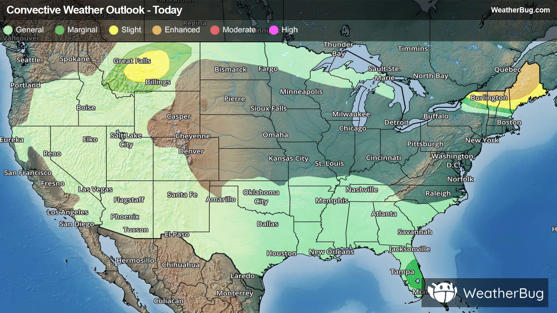
Weather Alerts For Talmage, CA
Flood Warning
-Flood Statement National Weather Service Eureka CA 755 AM PST Mon Dec 22 2025 ...The Flood Warning is extended for the following rivers in California... Russian River near Hopland affecting Mendocino County. For the Russian River...including Hopland...Minor flooding is forecast. PRECAUTIONARY/PREPAREDNESS ACTIONS... Motorists should not attempt to drive around barricades or drive cars through flooded areas. Flooding is occurring or is imminent. Most flood related deaths occur in automobiles. Do not attempt to cross water covered bridges, dips, or low water crossings. Never try to cross a flowing stream, even a small one, on foot. To escape rising water find another route over higher ground. Please report observed flooding to local emergency services or law enforcement and request they pass this information to the National Weather Service when you can do so safely. Additional information is available at weather.gov/eka. The next statement will be issued this morning at 1100 AM PST. && 755 AM PST Mon Dec 22 2025 ...FLOOD WARNING NOW IN EFFECT UNTIL THIS MORNING... * WHAT...Minor flooding is occurring and minor flooding is forecast. * WHERE...Russian River near Hopland. * WHEN...Until this morning. * IMPACTS...At 17.0 feet, Significant flooding of Highway 175 at the approaches to the Russian River bridge. Minor flooding of Highway 222 near Ukiah, and in crop land along the left and right banks of the Russian River near Hopland. * ADDITIONAL DETAILS... - At 7:45 AM PST Monday the stage was 16.2 feet. - Bankfull stage is 21.0 feet. - Recent Activity...The maximum river stage in the 24 hours ending at 7:45 AM PST Monday was 18.1 feet. - Forecast...The river will rise to 16.5 feet this morning. It will then fall below flood stage late this morning to 6.8 feet late tonight. It will rise above flood stage late tomorrow evening to 17.3 feet Wednesday morning. It will then fall below flood stage again early Wednesday afternoon to 13.2 feet Wednesday evening. It will rise above flood stage again early Thursday morning to 16.6 feet Thursday evening. It will then fall below flood stage again early Friday morning. - Flood stage is 15.0 feet. - Flood History...This crest compares to a previous crest of 17.3 feet on 01/05/2023. - http://www.weather.gov/safety/flood && Fld Observed Forecasts (8 am PST) Location Stg Stg Day/Time Tue Wed Thu Russian River Hopland 15.0 16.2 Mon 7 am 7.8 17.3 15.7 &&
Flood Watch
-URGENT - IMMEDIATE BROADCAST REQUESTED Flood Watch National Weather Service Eureka CA 744 AM PST Mon Dec 22 2025 Coastal Del Norte-Del Norte Interior-Northern Humboldt Coast- Southwestern Humboldt-Northern Humboldt Interior-Southern Humboldt Interior-Northern Trinity-Southern Trinity-Mendocino Coast-Northwestern Mendocino Interior-Northeastern Mendocino Interior-Southwestern Mendocino Interior-Southeastern Mendocino Interior-Northern Lake-Southern Lake- 744 AM PST Mon Dec 22 2025 ...FLOOD WATCH IN EFFECT FROM THIS EVENING THROUGH FRIDAY EVENING... * WHAT...Flooding caused by excessive rainfall is possible. * WHERE...Del Norte County, Humboldt County, Trinity County, Mendocino County, and Lake County. * WHEN...From this evening through Friday evening. * IMPACTS...There will be an increased risk of rock and land slides along roadways. Excessive runoff may result in flooding of rivers, creeks, streams, and other low-lying and flood-prone locations. Creeks and streams may rise out of their banks. Flooding may occur in poor drainage and urban areas. Area creeks and streams are running high and could flood with more heavy rain. * ADDITIONAL DETAILS... - Additional rounds of heavy rain are likely again starting tonight and continuing through Friday night. An additional 4-8 inches of total precipitation is possible through Friday. There will be breaks in the heavy precipitation, but heavy rain falling on already saturated ground will promote flooding impacts. Additional precipitation amounts of 4-8 inches are possible through Friday. - http://www.weather.gov/safety/flood PRECAUTIONARY/PREPAREDNESS ACTIONS... You should monitor later forecasts and be alert for possible Flood Warnings. Those living in areas prone to flooding should be prepared to take action should flooding develop. &&
High Wind Watch
-URGENT - WEATHER MESSAGE National Weather Service Eureka CA 529 AM PST Mon Dec 22 2025 Mendocino Coast-Northwestern Mendocino Interior-Northeastern Mendocino Interior-Southwestern Mendocino Interior-Southeastern Mendocino Interior- 529 AM PST Mon Dec 22 2025 ...HIGH WIND WATCH REMAINS IN EFFECT FROM TUESDAY EVENING THROUGH LATE TUESDAY NIGHT... * WHAT...Southeast winds 25 to 35 mph with gusts up to 60 mph possible. * WHERE...Mendocino County mainly over the higher terrain and along the coast. * WHEN...From Tuesday evening through late Tuesday night. * IMPACTS...Damaging winds could blow down trees and power lines. Widespread power outages are possible. Travel could be difficult, especially for high profile vehicles. PRECAUTIONARY/PREPAREDNESS ACTIONS... Monitor the latest forecasts and warnings for updates. &&