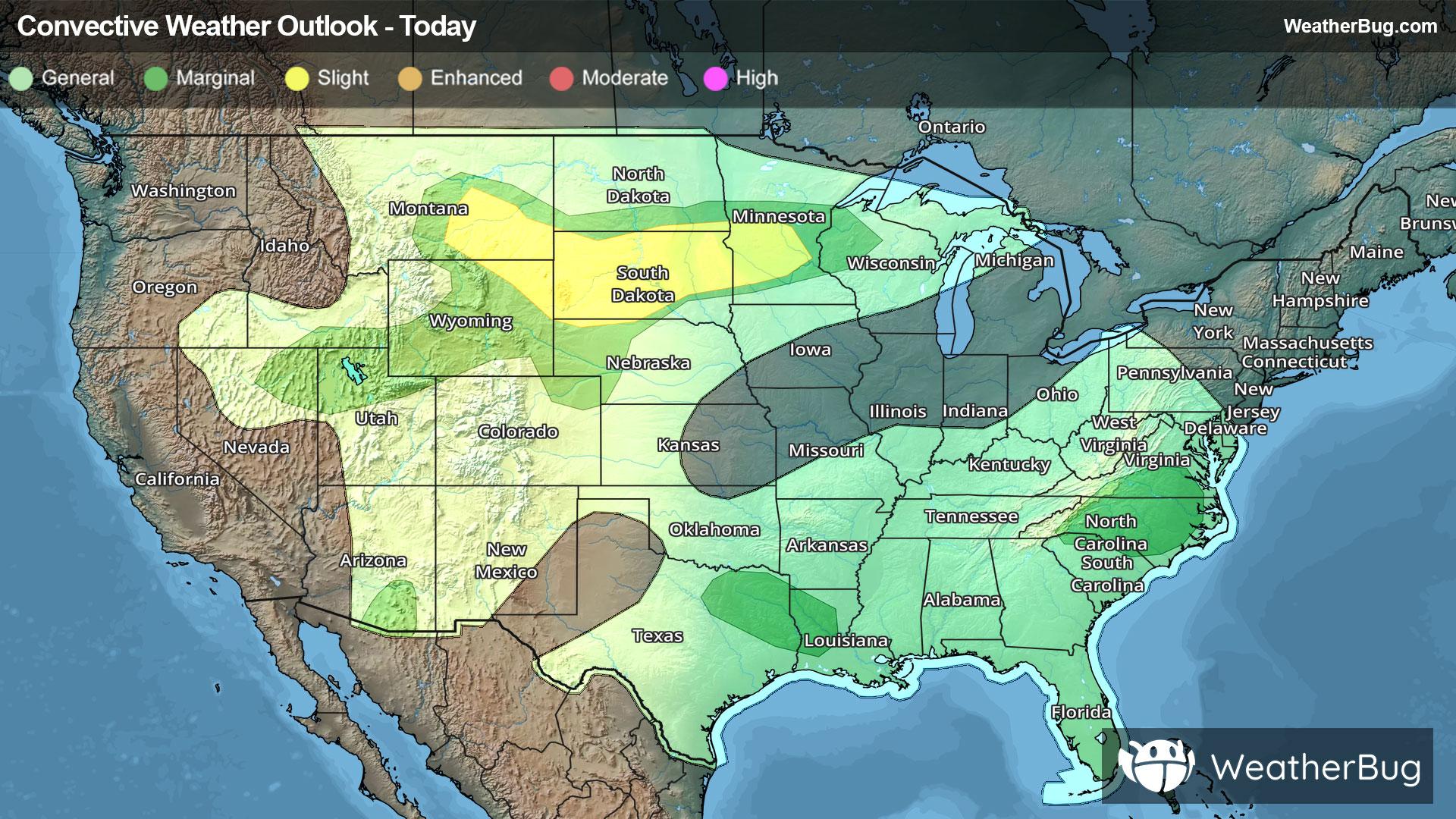
Severe Storms Erupt Across Northern Plains
Another round of strong to severe thunderstorms will form across parts of the northern Plains this afternoon and tonight.
Read More
# HEADLINE -------------------- HIGH RIP CURRENT RISK IN EFFECT THROUGH FRIDAY AFTERNOON COASTAL FLOOD ADVISORY NOW IN EFFECT UNTIL 4 PM CHST WEDNESDAY HIGH SURF WARNING REMAINS IN EFFECT UNTIL 4 PM CHST THURSDAY # SUMMARY -------------------- Guam-Rota-Tinian-Saipan- 519 AM ChST Wed Jul 8 2026 Updated for the WHERE additions and Additional Details. # DETAILS -------------------- WHAT Dangerously large breaking waves up to 16 feet. Minor coastal flooding expected. Life-threatening rip currents. WHERE For the Coastal Flood Advisory and High Surf Warning, along south and west facing shores of the Marianas. For the High Rip Current Risk, along south, west and north facing shores of the Marianas. WHEN For the High Surf Warning, until 4 PM ChST Thursday. For the Coastal Flood Advisory, until 4 PM ChST Wednesday. For the High Rip Current Risk, through Friday afternoon. IMPACTS Flooding of lots, parks, and roads with only isolated road closures expected. Breaking waves can sweep people off jetties and docks, and into dangerous seas. Life-threatening swimming conditions and significant beach erosion can be expected. ADDITIONAL DETAILS Typhoon Bavi (09W) and the trailing monsoon surge will keep producing significant swells that will continue to pummel the Marianas. Dangerous surf heights of up to 16 ft and coastal inundation of 1 to 2 ft can be expected now through late this afternoon, especially along west-facing shores. As Bavi continues to pull away and the leading monsoon surge weakens, swells and associated surf will gradually diminish, potentially dropping below dangerous levels by Thursday. Even so, surf will remain elevated enough to continue to produce high risk of rip currents along south, west and north facing reefs the next few days, while dropping to moderate along north reefs Thursday. ISSUED AT Wednesday, July 8, 2026 at 5:19 AM CHST ISSUED BY National Weather Service Tiyan GU HEADER URGENT - IMMEDIATE BROADCAST REQUESTED | Coastal Hazard Message...UPDATED # PRECAUTIONARY/PREPAREDNESS ACTIONS -------------------- Everyone should remain out of the water due to life-threatening surf conditions. Stay off of jetties, piers, and other waterside infrastructure.
# HEADLINE -------------------- HIGH RIP CURRENT RISK IN EFFECT THROUGH FRIDAY AFTERNOON COASTAL FLOOD ADVISORY NOW IN EFFECT UNTIL 4 PM CHST WEDNESDAY HIGH SURF WARNING REMAINS IN EFFECT UNTIL 4 PM CHST THURSDAY # SUMMARY -------------------- Guam-Rota-Tinian-Saipan- 519 AM ChST Wed Jul 8 2026 Updated for the WHERE additions and Additional Details. # DETAILS -------------------- WHAT Dangerously large breaking waves up to 16 feet. Minor coastal flooding expected. Life-threatening rip currents. WHERE For the Coastal Flood Advisory and High Surf Warning, along south and west facing shores of the Marianas. For the High Rip Current Risk, along south, west and north facing shores of the Marianas. WHEN For the High Surf Warning, until 4 PM ChST Thursday. For the Coastal Flood Advisory, until 4 PM ChST Wednesday. For the High Rip Current Risk, through Friday afternoon. IMPACTS Flooding of lots, parks, and roads with only isolated road closures expected. Breaking waves can sweep people off jetties and docks, and into dangerous seas. Life-threatening swimming conditions and significant beach erosion can be expected. ADDITIONAL DETAILS Typhoon Bavi (09W) and the trailing monsoon surge will keep producing significant swells that will continue to pummel the Marianas. Dangerous surf heights of up to 16 ft and coastal inundation of 1 to 2 ft can be expected now through late this afternoon, especially along west-facing shores. As Bavi continues to pull away and the leading monsoon surge weakens, swells and associated surf will gradually diminish, potentially dropping below dangerous levels by Thursday. Even so, surf will remain elevated enough to continue to produce high risk of rip currents along south, west and north facing reefs the next few days, while dropping to moderate along north reefs Thursday. ISSUED AT Wednesday, July 8, 2026 at 5:19 AM CHST ISSUED BY National Weather Service Tiyan GU HEADER URGENT - IMMEDIATE BROADCAST REQUESTED | Coastal Hazard Message...UPDATED # PRECAUTIONARY/PREPAREDNESS ACTIONS -------------------- Everyone should remain out of the water due to life-threatening surf conditions. Stay off of jetties, piers, and other waterside infrastructure.
# HEADLINE -------------------- HIGH RIP CURRENT RISK IN EFFECT THROUGH FRIDAY AFTERNOON COASTAL FLOOD ADVISORY NOW IN EFFECT UNTIL 4 PM CHST WEDNESDAY HIGH SURF WARNING REMAINS IN EFFECT UNTIL 4 PM CHST THURSDAY # SUMMARY -------------------- Guam-Rota-Tinian-Saipan- 519 AM ChST Wed Jul 8 2026 Updated for the WHERE additions and Additional Details. # DETAILS -------------------- WHAT Dangerously large breaking waves up to 16 feet. Minor coastal flooding expected. Life-threatening rip currents. WHERE For the Coastal Flood Advisory and High Surf Warning, along south and west facing shores of the Marianas. For the High Rip Current Risk, along south, west and north facing shores of the Marianas. WHEN For the High Surf Warning, until 4 PM ChST Thursday. For the Coastal Flood Advisory, until 4 PM ChST Wednesday. For the High Rip Current Risk, through Friday afternoon. IMPACTS Flooding of lots, parks, and roads with only isolated road closures expected. Breaking waves can sweep people off jetties and docks, and into dangerous seas. Life-threatening swimming conditions and significant beach erosion can be expected. ADDITIONAL DETAILS Typhoon Bavi (09W) and the trailing monsoon surge will keep producing significant swells that will continue to pummel the Marianas. Dangerous surf heights of up to 16 ft and coastal inundation of 1 to 2 ft can be expected now through late this afternoon, especially along west-facing shores. As Bavi continues to pull away and the leading monsoon surge weakens, swells and associated surf will gradually diminish, potentially dropping below dangerous levels by Thursday. Even so, surf will remain elevated enough to continue to produce high risk of rip currents along south, west and north facing reefs the next few days, while dropping to moderate along north reefs Thursday. ISSUED AT Wednesday, July 8, 2026 at 5:19 AM CHST ISSUED BY National Weather Service Tiyan GU HEADER URGENT - IMMEDIATE BROADCAST REQUESTED | Coastal Hazard Message...UPDATED # PRECAUTIONARY/PREPAREDNESS ACTIONS -------------------- Everyone should remain out of the water due to life-threatening surf conditions. Stay off of jetties, piers, and other waterside infrastructure.


