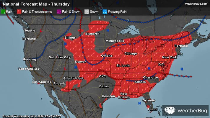
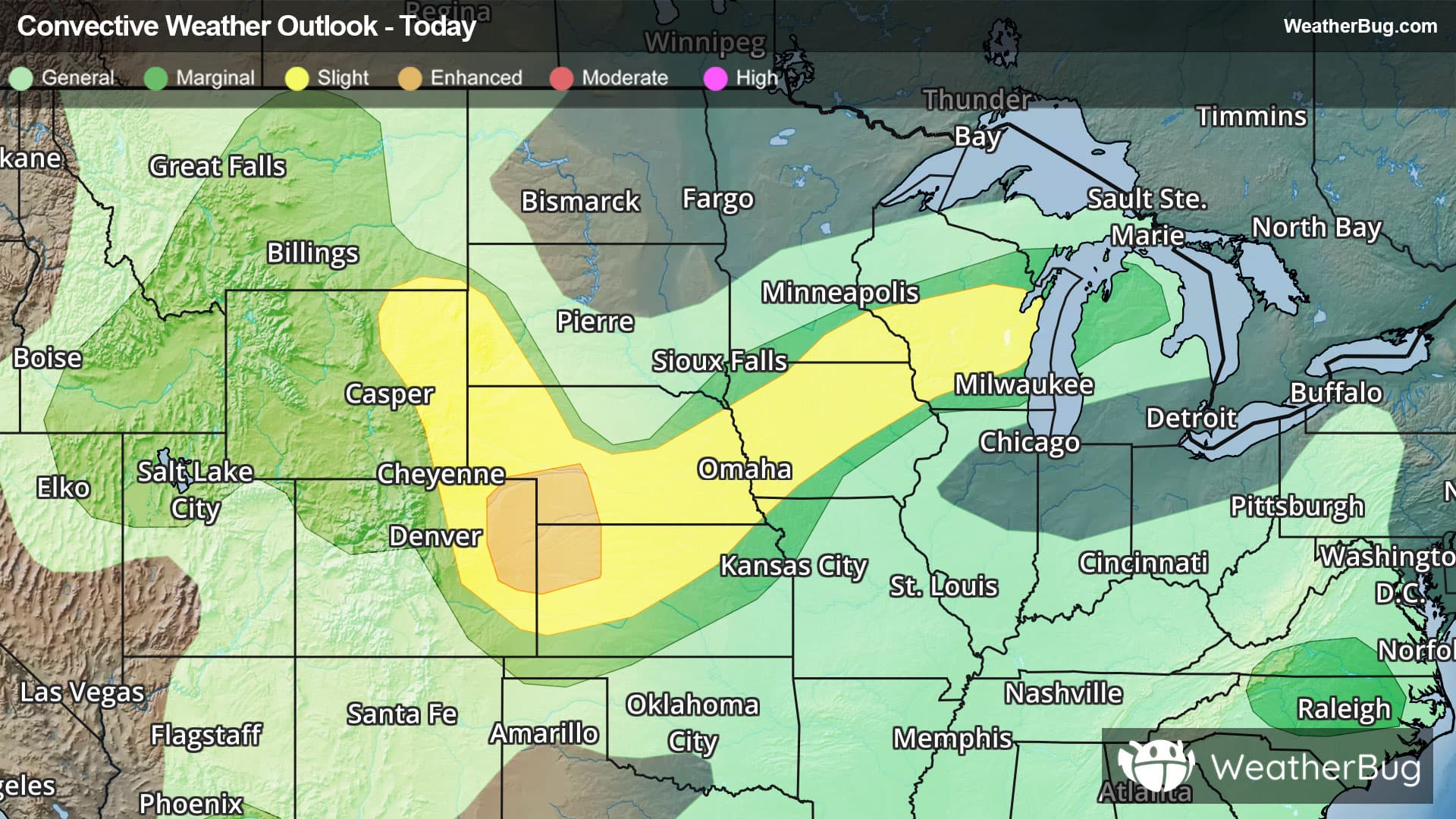
Weather Alerts For Village of Nagog Woods, MA
Flood Watch
-URGENT - IMMEDIATE BROADCAST REQUESTED Flood Watch National Weather Service Boston/Norton MA 1214 PM EDT Sun Mar 15 2026 .Heavy rain may fall on a deep primed snowpack leading to the melt increasing. Flows in rivers may increase quickly and reach critical levels. Hartford CT-Tolland CT-Windham CT-Western Franklin MA-Eastern Franklin MA-Northern Worcester MA-Central Middlesex MA-Western Essex MA-Eastern Essex MA-Western Hampshire MA-Western Hampden MA- Eastern Hampshire MA-Eastern Hampden MA-Southern Worcester MA- Western Norfolk MA-Southeast Middlesex MA-Suffolk MA-Eastern Norfolk MA-Northern Bristol MA-Western Plymouth MA-Eastern Plymouth MA-Southern Bristol MA-Southern Plymouth MA-Barnstable MA-Northern Middlesex MA-Northwest Providence RI-Southeast Providence RI-Western Kent RI-Eastern Kent RI-Bristol RI- Washington RI-Newport RI- Including the cities of Taunton, Chesterfield, Vernon, Coventry, Brockton, Framingham, Charlemont, Hartford, Willimantic, Quincy, West Greenwich, Norwood, Boston, Blandford, Foster, Springfield, Newport, Barre, Orange, Gloucester, Ayer, Putnam, Worcester, New Bedford, Smithfield, Providence, East Greenwich, Bristol, Fall River, Cambridge, Amherst, Fitchburg, Lowell, Lawrence, Plymouth, Northampton, Narragansett, Greenfield, Foxborough, Warwick, West Warwick, Mattapoisett, Falmouth, Union, Provincetown, Milford, Windsor Locks, Westerly, and Chatham 1214 PM EDT Sun Mar 15 2026 ...FLOOD WATCH IN EFFECT FROM LATE TONIGHT THROUGH TUESDAY MORNING... * WHAT...Flooding caused by rain and snowmelt is possible. * WHERE...Portions of northern Connecticut, including the following areas, Hartford CT, Tolland CT and Windham CT, Massachusetts, including the following areas, Barnstable MA, Central Middlesex MA, Eastern Essex MA, Eastern Franklin MA, Eastern Hampden MA, Eastern Hampshire MA, Eastern Norfolk MA, Eastern Plymouth MA, Northern Bristol MA, Northern Middlesex MA, Northern Worcester MA, Southeast Middlesex MA, Southern Bristol MA, Southern Plymouth MA, Southern Worcester MA, Suffolk MA, Western Essex MA, Western Franklin MA, Western Hampden MA, Western Hampshire MA, Western Norfolk MA and Western Plymouth MA, and Rhode Island, including the following areas, Bristol RI, Eastern Kent RI, Newport RI, Northwest Providence RI, Southeast Providence RI, Washington RI and Western Kent RI. * WHEN...From late tonight through Tuesday morning. * IMPACTS...Excessive runoff may result in flooding of rivers, creeks, streams, and other low-lying and flood-prone locations. Flooding may occur in poor drainage and urban areas. Area creeks and streams are running high and could flood with more heavy rain. * ADDITIONAL DETAILS... - http://www.weather.gov/safety/flood PRECAUTIONARY/PREPAREDNESS ACTIONS... You should monitor later forecasts and be alert for possible Flood Warnings. Those living in areas prone to flooding should be prepared to take action should flooding develop. &&
High Wind Watch
-URGENT - WEATHER MESSAGE National Weather Service Boston/Norton MA 1213 PM EDT Sun Mar 15 2026 Central Middlesex MA-Western Essex MA-Eastern Essex MA-Western Norfolk MA-Southeast Middlesex MA-Suffolk MA-Eastern Norfolk MA- Northern Bristol MA-Western Plymouth MA-Eastern Plymouth MA- Southern Bristol MA-Southern Plymouth MA-Barnstable MA-Dukes MA- Nantucket MA-Northwest Providence RI-Southeast Providence RI- Western Kent RI-Eastern Kent RI-Bristol RI-Washington RI-Newport RI-Block Island RI- Including the cities of Taunton, Coventry, Brockton, Framingham, New Shoreham, Quincy, West Greenwich, Norwood, Boston, Foster, Newport, Vineyard Haven, Gloucester, Nantucket, New Bedford, Smithfield, Providence, East Greenwich, Bristol, Fall River, Cambridge, Lowell, Lawrence, Plymouth, Narragansett, Foxborough, Warwick, West Warwick, Mattapoisett, Falmouth, Provincetown, Westerly, and Chatham 1213 PM EDT Sun Mar 15 2026 ...HIGH WIND WATCH REMAINS IN EFFECT FROM MONDAY AFTERNOON THROUGH LATE MONDAY NIGHT... * WHAT...South winds 20 to 30 mph with gusts up to 60 mph possible. * WHERE...Portions of eastern, northeastern, and southeastern Massachusetts and northern and southern Rhode Island. * WHEN...From Monday afternoon through late Monday night. * IMPACTS...Damaging winds could blow down trees and power lines. Power outages are possible. Travel could be difficult, especially for high profile vehicles. PRECAUTIONARY/PREPAREDNESS ACTIONS... Monitor the latest forecasts and warnings for updates. &&