


Both Atlantic and Pacific Aflutter With Tropical Activity
Hurricane season has picked up in a hurry, with one tropical storm in the Atlantic already forming. Two other tropical disturbances have their sights set on forming this week, one in the Atlantic and one in the Pacific.
As of 9 p.m. GMT (5 p.m. EDT), Tropical Storm Cristobal was located near 37.2 N, 41.0W, or about 765 miles west of the Azores in the central Atlantic. It was moving east at 21 mph with maximum sustained winds of 45 mph. Its minimum central pressure was 29.77 inches of mercury or 1008 mb.
Cristobal formed from a disturbance moving across the mid-latitude Atlantic, taking on tropical characteristics as it interacted with the Gulf Stream this morning. It has weakened since this morning as it starts to move into colder water, and this will spell the end for Cristobal in the next 24 to 36 hours, and its remnants will pass harmlessly west of the Azores.
Another tropical disturbance is coming together in the southern Atlantic. This disturbance is likely to become a tropical storm in the next few days as it feeds off the warm tropical waters. By the weekend, it will likely slide across the Lesser Antilles. After that, conditions are less favorable in the Caribbean, and what could become Tropical Storm Dolly could find itself struggling to maintain its organization by Monday.
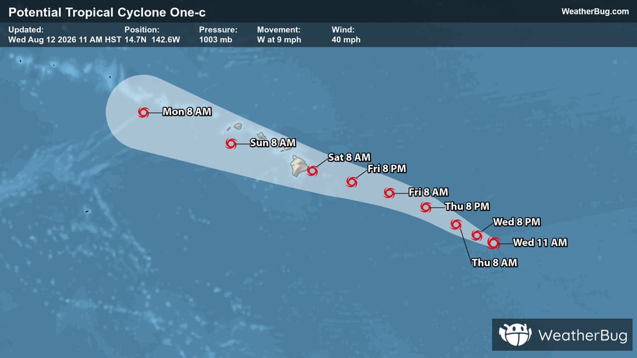
Meanwhile, the biggest risk for development comes from the central Pacific, where a Potential Tropical Cyclone is eyeing Hawaii this weekend. As of 11 a.m. HST (5 p.m. EDT) PTC #1 was located near 14.7 N, 142.6 W, or about 895 miles from Hawaii’s Big Island, and 1100 miles east-southeast of Honolulu. The developing storm was moving west at 9 mph, with winds of 40 mph. Its central pressure is 29.62 inches, or 1003 mb.
This system is likely to organize into a tropical storm over the next day or so, receiving a name from Hawaii’s hurricane list, “Lala.” It will likely make a bee-line toward the southern half of the island chain this weekend as it strengthens into a strong tropical storm or hurricane.
Heavy rain and strong winds along with high seas and dangerous riptides would all be expected for Hawaii, with the strongest wind and rain likely to remain close to the center’s path across the Big Island. Thanks to the mountainous terrain, flash flooding and mudslides are possible and could make roads impassible in the Hilo and Honolulu metro areas.
Its geographic position in the tropics obviously makes Hawaii a candidate for tropical systems, although it is rare for a tropical system to survive to the 50th state. Cooler water to Hawaii’s east act as a shield, leaving only a handful of systems to approach. Remnants of these storms are what typically brings heavy rain and wind to Hawaii as they pass the region.
The better bet for tropical development comes from those storms that develop well to the south and southeast of the islands. Here, the storm can avoid the cool water shield and organize into a powerful storm. The best example of this pattern would be Hurricane Iniki, which pummeled Kauai and the western islands in September 1992 as it approached from the south.
Residents and visitors to Hawaii are urged to keep an eye on the development of this system over the next few days, and make preparations by having food and water as well as extra charging equipment for your mobile devices ready. Take the time now to find multiple evacuation routes from your location, in case the preferred one is blocked or jammed.