Severe Thunderstorms Set to Roam the Northern Plains
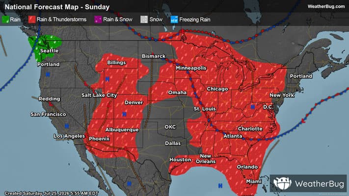
Severe weather may be found across the northern Plains this afternoon, with these storms slowly progressing east and reaching the East Coast by the early to middle part of next week.
Read More
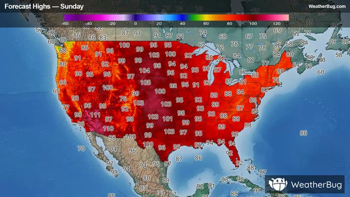
# HEADLINE -------------------- EXTREME HEAT WARNING REMAINS IN EFFECT FROM NOON TODAY TO 9 PM CDT MONDAY # DETAILS -------------------- WHAT Dangerously hot conditions with heat index values near 110. WHERE Portions of central and west central Illinois. WHEN From noon today to 9 PM CDT Monday. IMPACTS Heat related illnesses increase significantly during extreme heat and high humidity events. ISSUED AT Sunday, July 26, 2026 at 3:39 AM CDT ISSUED BY National Weather Service Lincoln IL HEADER URGENT - WEATHER MESSAGE # PRECAUTIONARY/PREPAREDNESS ACTIONS -------------------- Drink plenty of fluids, stay in an air-conditioned room, stay out of the sun, and check up on relatives and neighbors. Do not leave young children and pets in unattended vehicles. Car interiors will reach lethal temperatures in a matter of minutes. # AREAS AFFECTED -------------------- Menard, Cass, Christian, Fulton, Knox, Logan, Mason, Morgan, Peoria, Sangamon, Schuyler, Scott, Stark, Tazewell Including the cities of Petersburg, Lincoln, Peoria, Havana, Taylorville, Toulon, Beardstown, Jacksonville, Winchester, Canton, Galesburg, Pekin, Rushville, and Springfield
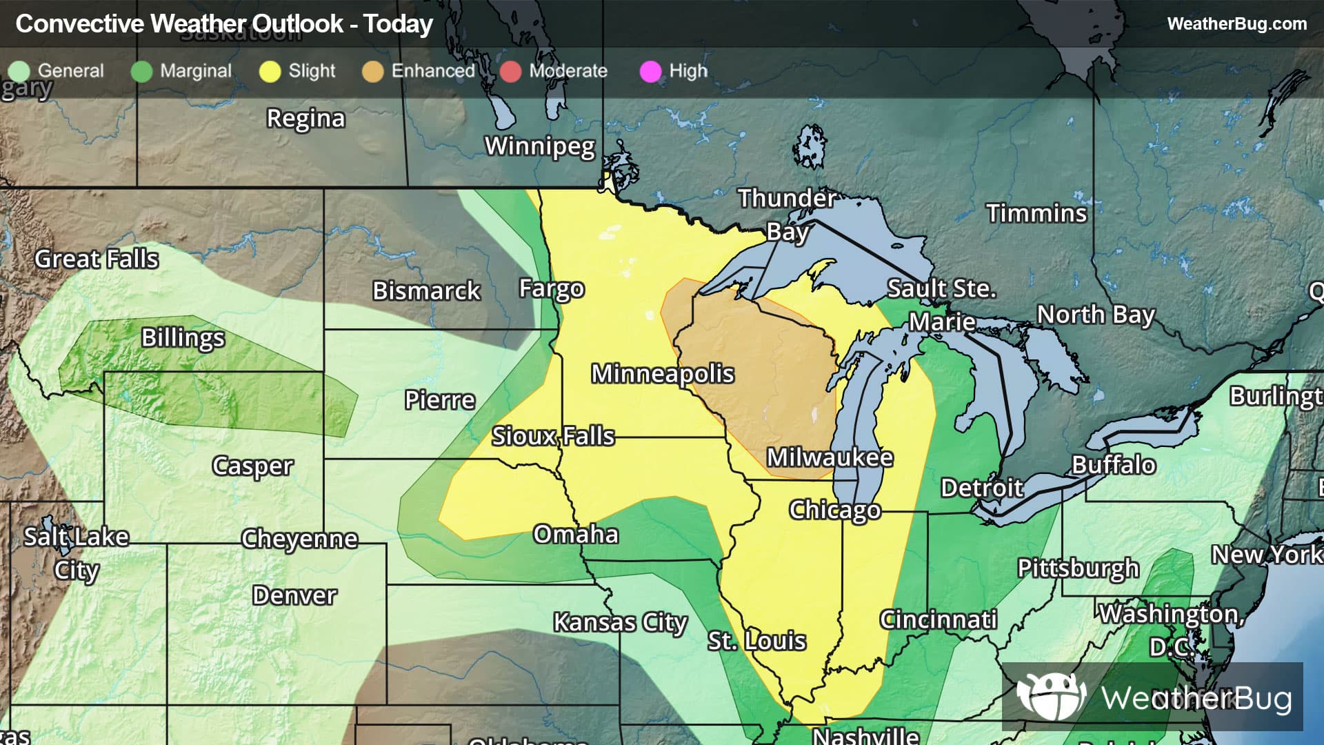
There is a Slight Severe Storm Risk for your location. Continue reading for today's outlook from the National Weather Service's Storm Prediction Center. -------------------- National Severe Storm Outlook THERE IS AN ENHANCED RISK OF SEVERE THUNDERSTORMS ACROSS THE UPPER MIDWEST/GREAT LAKES SUMMARY Severe thunderstorms capable of large to very large hail, damaging winds (possibly 75+ mph), and tornado risk are expected from the upper Mississippi Valley and Great Lakes southwestward into Nebraska, mainly this afternoon and tonight. Upper Midwest and Great Lakes Have upgraded portions of the region to an Enhanced Risk including Wisconsin and nearby far eastern Minnesota and Upper Michigan. An upper ridge will remain anchored from the Southwest into the central Rockies and High Plains through tonight. Seasonably strong northwesterly flow aloft will overspread a very warm, moist, and unstable environment from parts of the Upper Midwest and Great Lakes into the central Plains. Aided by favorably-timed MCV/mid-level impulse, the most likely initiation zone for diurnal storm development is expected to be across northern Minnesota into Wisconsin. Initial intense supercell development is expected in this zone, posing a threat of large to very large hail, localized severe wind gusts, and potentially at least some tornado risk. Upscale growth into one or more intense wind-producing southeastward-moving clusters are expected into this evening amidst the enhanced northwesterly flow aloft. Middle Mississippi Valley Residual MCV influences may semi-focus renewed thunderstorm development into a very unstable environment this afternoon regionally, with potential storm organization aided by semi-strong mid/high-level winds for the season. Damaging winds would likely be the most probable concern as storms potentially cluster and spread south-southeastward. Nebraska/eastern South Dakota/western Iowa A somewhat separate area of potential severe-storm development is expected from parts of central Nebraska into southeast South Dakota. Initiation is expected near a weak surface trough as temperatures warm to near/above 100 F as CINH erodes. MLCAPE of near/above 1500 J/kg and effective shear of 30-40 kt will favor development of a few organized cells and/or clusters. Severe gusts of 60-80 mph appear to be the most likely hazard within the hot/well-mixed environment. Isolated hail may also occur with any supercell, even with rather warm temperatures aloft. Mid-Atlantic into the Carolinas/Georgia/north Florida A seasonably deep upper trough will persist across much of the eastern CONUS today. A modest increase in northwesterly mid-level winds are expected from the Mid-Atlantic into the Carolinas, Georgia and northern Florida. Relatively cool conditions, weak lapse rates, and the potential influence of smoke will temper destabilization across the Mid Atlantic. However, MLCAPE increasing to near 1000 J/kg amid 25-35 kt of effective shear may support occasional storm organization, with a primary threat of locally damaging winds. Stronger heating/destabilization is expected farther south across the Carolinas into Georgia and Florida. Deep-layer flow/shear will be somewhat weaker compared to areas farther north, but may still be sufficient for transient storm organization and a localized damaging-wind threat. Southern Montana/northern Wyoming/Black Hills High-based convection is expected to develop this afternoon along the northern periphery of the upper ridge, with the greatest storm coverage expected across parts of northern Wyoming and southern Montana. Overall buoyancy is expected to remain weak, but inverted-v profiles will support a threat of strong to localized severe gusts as storms spread eastward toward the Black Hills before weakening into mid/late evening.