Severe Thunderstorms Set to Roam the Northern Plains
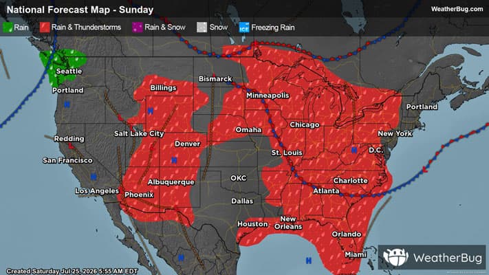
Severe weather may be found across the northern Plains this afternoon, with these storms slowly progressing east and reaching the East Coast by the early to middle part of next week.
Read More
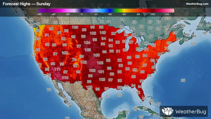
# HEADLINE -------------------- HEAT ADVISORY IN EFFECT FROM 7 AM TO 10 PM CDT MONDAY EXTREME HEAT WARNING NOW IN EFFECT UNTIL 7 AM CDT MONDAY # DETAILS -------------------- WHAT For the Extreme Heat Warning, dangerously hot conditions with heat index values up to 114. For the Heat Advisory, heat index values up to 106 expected. WHERE Harrison and Shelby Counties. WHEN For the Extreme Heat Warning, until 7 AM CDT Monday. For the Heat Advisory, from 7 AM to 10 PM CDT Monday. IMPACTS Heat related illnesses increase significantly during extreme heat and high humidity events. Hot temperatures and high humidity may cause heat illnesses. ISSUED AT Sunday, July 26, 2026 at 12:42 PM CDT ISSUED BY National Weather Service Omaha/Valley NE HEADER URGENT - WEATHER MESSAGE # PRECAUTIONARY/PREPAREDNESS ACTIONS -------------------- Drink plenty of fluids, stay in an air-conditioned room, stay out of the sun, and check up on relatives and neighbors. Do not leave young children and pets in unattended vehicles. Car interiors will reach lethal temperatures in a matter of minutes. Take extra precautions when outside. Wear lightweight and loose fitting clothing. Try to limit strenuous activities to early morning or evening. Take action when you see symptoms of heat exhaustion and heat stroke. # AREAS AFFECTED -------------------- Harrison, Shelby Including the cities of Logan, Harlan, Missouri Valley, Woodbine, and Dunlap
# HEADLINE -------------------- HEAT ADVISORY IN EFFECT FROM 7 AM TO 10 PM CDT MONDAY EXTREME HEAT WARNING NOW IN EFFECT UNTIL 7 AM CDT MONDAY # DETAILS -------------------- WHAT For the Extreme Heat Warning, dangerously hot conditions with heat index values up to 114. For the Heat Advisory, heat index values up to 106 expected. WHERE Harrison and Shelby Counties. WHEN For the Extreme Heat Warning, until 7 AM CDT Monday. For the Heat Advisory, from 7 AM to 10 PM CDT Monday. IMPACTS Heat related illnesses increase significantly during extreme heat and high humidity events. Hot temperatures and high humidity may cause heat illnesses. ISSUED AT Sunday, July 26, 2026 at 12:42 PM CDT ISSUED BY National Weather Service Omaha/Valley NE HEADER URGENT - WEATHER MESSAGE # PRECAUTIONARY/PREPAREDNESS ACTIONS -------------------- Drink plenty of fluids, stay in an air-conditioned room, stay out of the sun, and check up on relatives and neighbors. Do not leave young children and pets in unattended vehicles. Car interiors will reach lethal temperatures in a matter of minutes. Take extra precautions when outside. Wear lightweight and loose fitting clothing. Try to limit strenuous activities to early morning or evening. Take action when you see symptoms of heat exhaustion and heat stroke. # AREAS AFFECTED -------------------- Harrison, Shelby Including the cities of Logan, Harlan, Missouri Valley, Woodbine, and Dunlap
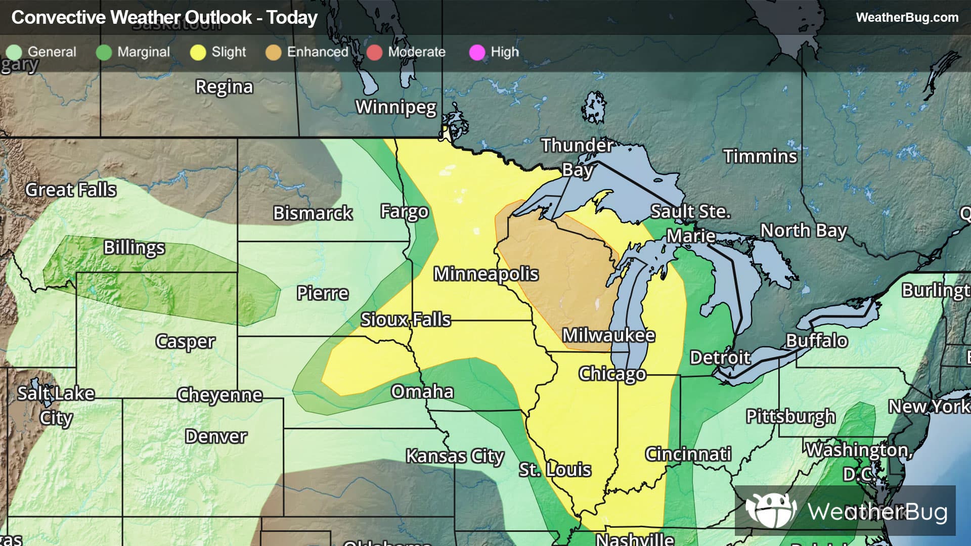
There is a Marginal Severe Storm Risk for your location. Continue reading for today's outlook from the National Weather Service's Storm Prediction Center. -------------------- National Severe Storm Outlook THERE IS AN ENHANCED RISK OF SEVERE THUNDERSTORMS ACROSS THE UPPER MIDWEST/GREAT LAKES SUMMARY Severe thunderstorms capable of large to very large hail, damaging winds (possibly 75+ mph), and tornado risk are expected from the upper Mississippi Valley and Great Lakes southwestward into Nebraska, mainly this afternoon and tonight. Upper Midwest/Great Lakes Initial supercell storms are expected to develop across northern MN/WI later this afternoon, aided by a favorably timed shortwave impulse rounding the Plains upper ridge. Another MCV/shortwave impulse located over the Dakotas at midday will also spread east/southeast across southern/central MN this afternoon. These features will provide support for one or more focused areas of thunderstorm development. Initial supercells will pose an all-hazards risk, including locally severe wind gusts, very large hail, and a couple of tornadoes. With time into the evening, initial supercells may grow into one or two small bowing MCSs. This storm mode transition will support an increased risk for intense damaging wind swaths this evening into tonight as convection spreads southeast along a strong instability/moisture gradient across WI and the Lake Michigan vicinity. Mid-Mississippi/Lower Ohio/Tennessee Valleys Multiple areas of strong to severe storms will be possible this afternoon into tonight from near the MS River into IL/IN/KY/TN. Thunderstorm development may be aided by a weak shortwave impulse/MCV migrating southeast from IA at midday and into the Lower OH Valley this evening. Storms are expected to develop along a corridor of differential heating near/just east of the MS River where mostly clear skies this morning have already resulted in temperatures approaching 85-90 F, while scattered clouds further east will maintain somewhat lower high temperatures. Thunderstorm clusters this afternoon will pose a risk for severe/damaging wind gusts. Sufficient clustering may occur and some upscale development into a forward propagating bow may occur across the Lower Ohio Valley vicinity this evening, and wind probabilities have been increased to 30 percent for parts of southern IL/IN and western KY. This activity could be maintained southward during the overnight hours as far south as northern AL/GA given favorable instability and sufficiently strong northwesterly flow aloft. Damaging wind gusts could persist with this activity as it spreads south/southeast across TN into AL/GA toward early Monday morning. NE/SD/IA A deeply mixed and hot boundary layer will develop this afternoon/early evening in the vicinity of a weak surface trough from NE into southeast SD/northwest IA. Very steep lapse rates aloft will foster 1500-2000 J/kg MLCAPE. Vertically veering wind profiles and increasing northwesterly flow aloft will provide 25-35 kt effective shear magnitudes and a few organized cells/clusters may develop by late afternoon. Damaging wind gusts of 60-80 mph would be the main hazard with this activity. While temperatures are somewhat warm aloft, the strongest storms could produce sporadic large hail. Mid-Atlantic/Carolinas/Southeast GA/Northern FL Upper troughing will persist today across the East, though some enhancement to northwesterly flow aloft is expected. Relatively cool conditions, weak lapse rates, and the potential influence of smoke will temper destabilization across the Mid-Atlantic. Nevertheless, MLCAPE 1000 J/kg amid 25-35 kt of effective shear may support occasional organized storms capable of producing locally damaging gusts. Stronger heating/destabilization is expected farther south across the Carolinas into GA/FL. Deep-layer flow/shear will be somewhat weaker compared to farther north, but may still be sufficient for transient storm organization with sporadic locally damaging winds possible. Southeast MT/northern WY/Black Hills vicinity High-based convection is expected to develop this afternoon along the northern periphery of the upper ridge, with the greatest storm coverage expected across parts of northern Wyoming and southern Montana. Overall buoyancy is expected to remain weak, but inverted-v profiles will support a threat of strong to localized severe gusts as storms spread eastward toward the Black Hills before weakening into mid/late evening.