Weather Alerts For Germantown, MD
Severe Thunderstorm Watch
-# SUMMARY -------------------- SEVERE THUNDERSTORM WATCH 321 REMAINS IN EFFECT UNTIL 900 PM EDT FOR THE FOLLOWING LOCATIONS MD . MARYLAND COUNTIES INCLUDED ARE ANNE ARUNDEL BALTIMORE CALVERT CHARLES HARFORD HOWARD MONTGOMERY PRINCE GEORGES ST. MARYS MARYLAND INDEPENDENT CITIES INCLUDED ARE BALTIMORE CITY # DETAILS -------------------- ISSUED AT Friday, June 12, 2026 at 5:13 PM EDT ISSUED BY NWS STORM PREDICTION CENTER NORMAN OK HEADER SEVERE THUNDERSTORM WATCH OUTLINE UPDATE FOR WS 321
Special Weather Statement
-# HEADLINE -------------------- SEVERE WEATHER SAFETY RULES # SUMMARY -------------------- Severe thunderstorms capable of producing damaging winds and large hail are possible through this evening across portions of eastern West Virginia, northern and central Virginia, central and southern Maryland, and the District of Columbia. Residents in these areas should monitor this situation very closely and ensure your NOAA weather radios are set to alert mode. Severe weather warnings for imminent damaging storms may become necessary. Here are some safety rules to keep in mind when severe weather is expected or is occurring. If a warning is issued, seek shelter indoors immediately. Stay tuned to NOAA weather radio, commercial radio, information sources from your phone, or television for the latest on this potential severe weather event. Additional weather information can be found at weather.gov/washington or weather.gov/baltimore. # DETAILS -------------------- ISSUED AT Friday, June 12, 2026 at 2:51 PM EDT ISSUED BY National Weather Service Baltimore MD/Washington DC HEADER Special Weather Statement # AREAS AFFECTED -------------------- Central and Southeast Prince William/Manassas/Manassas Park, Chesapeake Bay from Drum Point MD to Smith Point VA, Chesapeake Bay from North Beach to Drum Point MD, Chesapeake Bay from Pooles Island to Sandy Point MD, Chesapeake Bay from Sandy Point to North Beach MD, Chester River to Queenstown MD, Choptank River to Cambridge MD and the Little Choptank River, Clarke, Culpeper, Northern Virginia Blue Ridge, Northwest Howard, Northwest Montgomery, Northwest Prince William, Patapsco River including Baltimore Harbor, Patuxent River to Broomes Island MD, Prince Georges, Southeast Harford, Spotsylvania, Tangier Sound and the inland waters surrounding Bloodsworth Island, Tidal Potomac from Cobb Island MD to Smith Point VA, Tidal Potomac from Indian Head to Cobb Island MD, Tidal Potomac from Key Bridge to Indian Head MD, Western Highland, Western Pendleton, Albemarle, Anne Arundel, Arlington/Falls Church/Alexandria, Augusta, Calvert, Central and Southeast Howard, Central and Southeast Montgomery, Central Virginia Blue Ridge, Charles, Chesapeake Bay north of Pooles Island MD, District of Columbia, Eastern Bay, Eastern Highland, Eastern Loudoun, Eastern Pendleton, Fairfax, Greene, Hardy, King George, Madison, Nelson, Northern Baltimore, Northern Fauquier, Northwest Harford, Orange, Page, Rappahannock, Rockingham, Shenandoah, Southern Baltimore, Southern Fauquier, St. Marys, Stafford, Warren, Western Loudoun Including the cities of Adams Morgan, Washington, Randallstown, Long Green, Glyndon, Reisterstown, Owings Mills, Cockeysville, Timonium, Baltimore, Fells Point, Park Heights, Bowie, Suitland-Silver Hill, Clinton, College Park, Tantallon, Greenbelt, Montpelier, Glen Burnie, Annapolis, Ridgeway, Severn, South Gate, Severna Park, Arnold, St. Charles, Waldorf, Dameron, Lexington Park, Piney Point, Ridge, California, Callaway, Sotterley, Cove Point, Drum Point, Chesapeake Beach, Mount Harmony, Broomes Island, Long Beach, Dunkirk, Boyds, Germantown, Four Corners, Silver Spring, Glenmont, Bethesda, Gaithersburg, Aspen Hill, Rockville, Lisbon, Poplar Springs, Watersville, Glenelg, Glenwood, West Friendship, Dayton, Clarksville, Columbia, Simpsonville, Historic Ellicott City, Woodstock, Bynum, Hickory, Bel Air, Fallston, Harford Furnace, Abingdon, Edgewood, Magnolia, Aberdeen, Carsins, Churchville, Christian, Staunton, Waynesboro, Spottswood, Stuarts Draft, Harrisonburg, Linville, Clary, Strasburg, Alonzaville, Hawkinstown, Mount Clifton, Mount Jackson, Compton, Fairview, Hamburg, Kimball, Luray, Rileyville, Ingham, Arco, Bentonville, Buckton, Cedarville, Front Royal, Glen Echo, Howellsville, Berryville, Stringtown, Greenfield, Charlottesville, Overton, Shady Grove, Fordsville, Five Forks, Madison Mills, Twymans Mill, Castleton, Flint Hill, Hackleys Crossroads, Rock Mills, Burr Hill, Everona, Lahore, Madison Run, Nasons, Orange, Unionville, Cardova, Catalpa, Culpeper, Reva, Stevensburg, Winston, Rapidan, Burke, Fairfax Station, Reston, Annandale, Chantilly, Langley, McLean, Reagan National Airport, Arlington, Ballston, Barcroft, Cherrydale, Rivercrest, Rosslyn, Arkendale, Garrisonville, Shiloh, Widewater, Brookfield, Falmouth, Glendie, Fredericksburg, Rollins Fork, Dahlgren, Airlie, Bethel, Warrenton, Turnbull, Hightown, Mill Gap, New Hampden, Clover Creek, Liberty, McDowell, Monterey, Mustoe, Possum Trot, Sirons Mill, Lucketts, Gleedsville, Leesburg, Dulles International Airport, Oak Grove, Sterling Park, Countryside, Chester Gap, Skyland, Montebello, Haymarket, Woolsey, Dale City, Independent Hill, Aden, Manassas, Lake Ridge, Woodbridge, Montclair, Brake, Bean Settlement, Fisher, McNeill, Moorefield, Riverton, Brandywine, Franklin, Oak Flat, Ruddle, and Sugar Grove
Lightning Alert
-Closest strike: 14.91 miles Storms Approaching Stay alert and frequently check WeatherBug to see if storms are moving toward you. Be mindful that new storms can also form with little notice.
Severe Storm Risk
-There is a Slight Severe Storm Risk for your location. Continue reading for today's outlook from the National Weather Service's Storm Prediction Center. -------------------- 
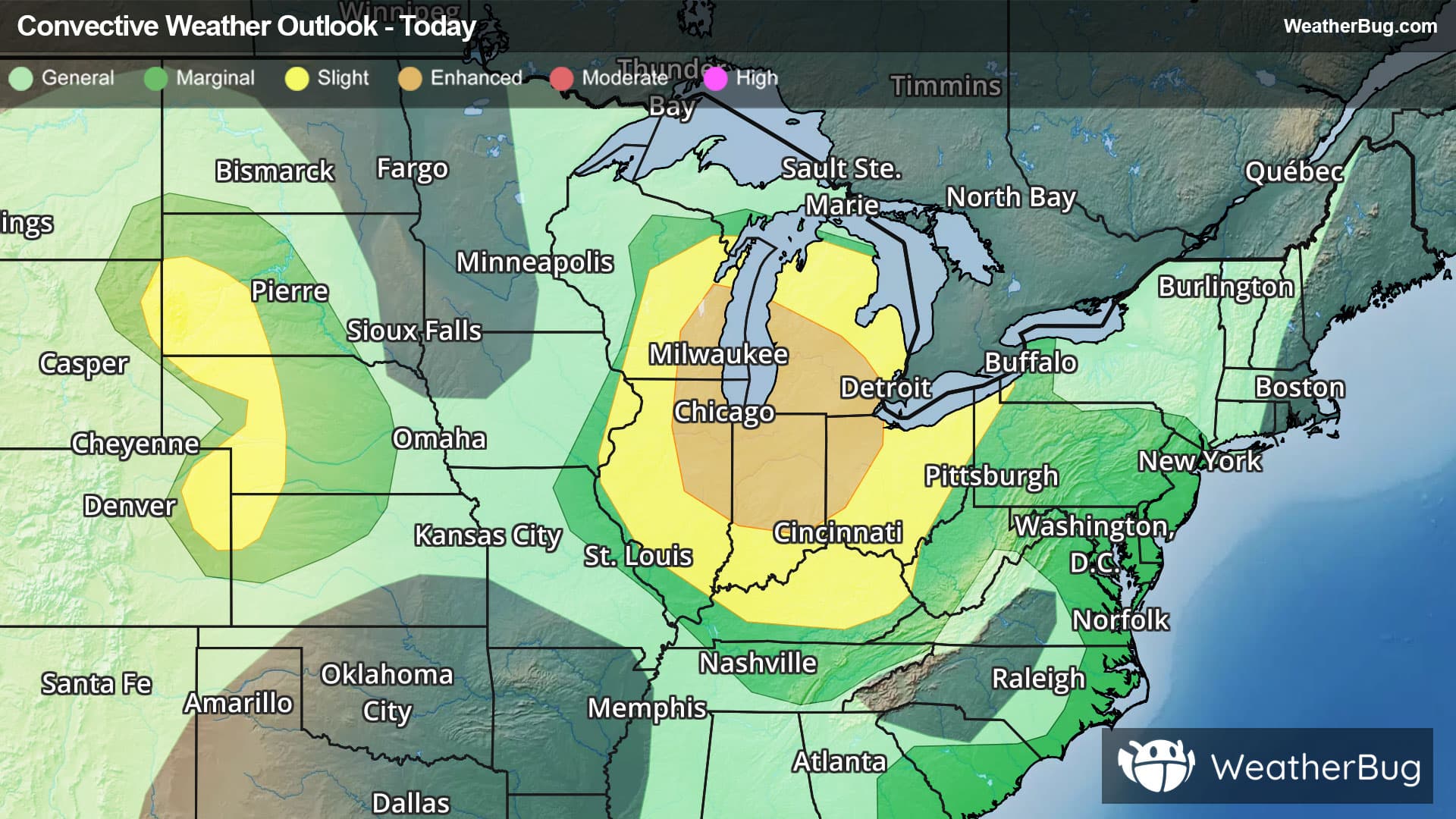
National Severe Storm Outlook THERE IS A SLIGHT RISK OF SEVERE THUNDERSTORMS ACROSS PARTS OF THE NORTHEAST...MID-ATLANTIC...AND SOUTHERN APPALACHIANS AS WELL AS PARTS OF THE SOUTHERN HIGH PLAINS SUMMARY Strong to severe storms capable of damaging winds are expected across parts of the Appalachians, Mid-Atlantic, and Northeast, mainly this afternoon and evening. Severe storms with a threat of large hail and severe wind gusts will also be possible across parts of the south-central High Plains. 20z Update The previous forecast remains on track with minimal changes required to the existing probability lines based on ongoing convective trends and recent model guidance. The primary outlook amendment was the introduction of 5% hail probabilities across portions of eastern Nebraska. Nebraska 12z ensemble guidance hinted at thunderstorm development across eastern NE during the 09-12 UTC period as a weak low-level cold front impinges on a plume of northward returning moisture. More recent runs of the RAP/RRFS/HRRR continue to show this potential and depict a fairly robust thermodynamic environment featuring MUCAPE values upwards of 4000 J/kg. 18 UTC RAOBS from the southern High Plains and Rockies sampled steep mid-level lapse rates that will advect eastward over the next 18 hours, and recent model solutions appear to be capturing surface moisture return well. These trends lend sufficient confidence to introduce a targeted hail risk area. Mississippi/Alabama 5% wind probabilities were removed across northern MS/AL based on recent radar trends, which depict the outflow boundary of a decaying MCS rapidly progressing south and undercutting developing convection. Strong buoyancy immediately downstream may support some localized damaging wind threat through the afternoon, but latest model guidance largely shows diminishing convective activity as the outflow surges south.