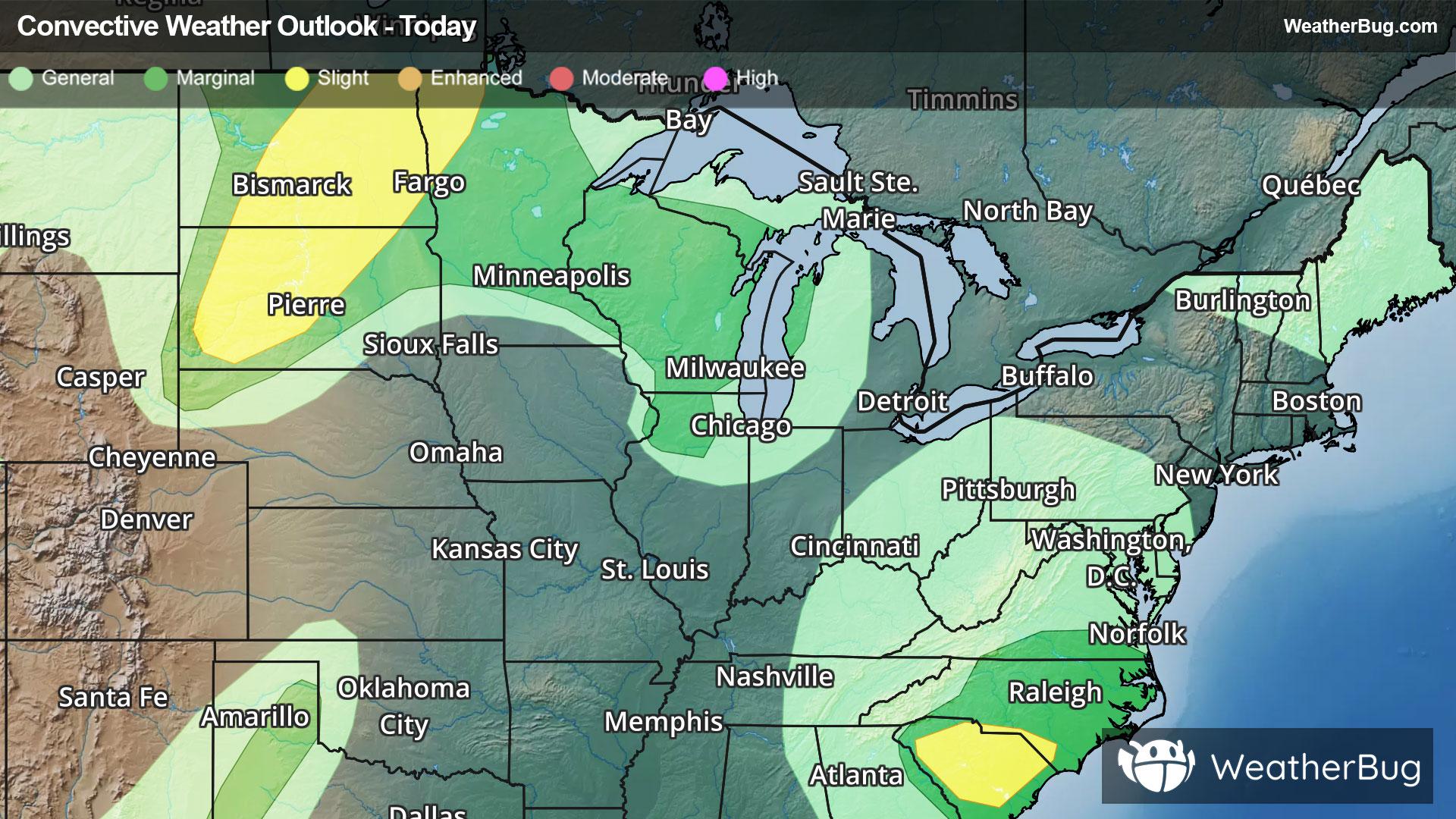
Dangerous Storms, Flooding Impact Northern Plains To The Carolinas
Strong to severe thunderstorms will occur across the northern Plains today bringing risks that will impact travel.
Read More
# HEADLINE -------------------- RED FLAG WARNING REMAINS IN EFFECT UNTIL 9 PM MDT THIS EVENING FOR GUSTY WINDS AND LOW RELATIVE HUMIDITY FOR FIRE WEATHER ZONES 225, 229, AND 230 RED FLAG WARNING IN EFFECT FROM 3 AM TO 10 PM MDT MONDAY FOR GUSTY WINDS AND LOW RELATIVE HUMIDITY FOR FIRE WEATHER ZONES 225, 229, AND 230 FIRE WEATHER WATCH IN EFFECT FROM TUESDAY MORNING THROUGH TUESDAY EVENING FOR GUSTY WINDS AND LOW RELATIVE HUMIDITY FOR FIRE WEATHER ZONES 225, 229, AND 230 # SUMMARY -------------------- The National Weather Service in Pueblo has issued a Red Flag Warning for gusty winds and low relative humidity, which is in effect from 3 AM to 10 PM MDT Monday. A Fire Weather Watch has also been issued. This Fire Weather Watch for gusty winds and low relative humidity is in effect from Tuesday morning through Tuesday evening. The Fire Weather Watch is no longer in effect. # DETAILS -------------------- AFFECTED AREA Fire Weather Zones 225, 229 and 230. WINDS for today southwest 25 to 35 with gusts to 50 mph, for Monday southwest 25 to 35 mph with gusts up to 65 mph with the highest gusts in the morning, for Tuesday southwest 15 to 25 with gusts to 45mph. RELATIVE HUMIDITY 5 to 10 percent. IMPACTS Extreme fire danger is expected. Fires will uncontrollably spread and be very destructive. ISSUED AT Sunday, June 28, 2026 at 12:50 PM MDT ISSUED BY National Weather Service Pueblo CO HEADER URGENT - FIRE WEATHER MESSAGE # PRECAUTIONARY/PREPAREDNESS ACTIONS -------------------- A Red Flag Warning means that critical fire weather conditions are either occurring now, or will shortly. A combination of strong winds, low relative humidity, and warm temperatures can contribute to extreme fire behavior. A Fire Weather Watch means that critical fire weather conditions are forecast to occur. Listen for later forecasts and possible Red Flag Warnings. # AREAS AFFECTED -------------------- Southern Front Range Including Sangre De Cristo Mountains/Wet Mountains/La Veta Pass-Huerfano County
# HEADLINE -------------------- RED FLAG WARNING REMAINS IN EFFECT UNTIL 9 PM MDT THIS EVENING FOR GUSTY WINDS AND LOW RELATIVE HUMIDITY FOR FIRE WEATHER ZONES 225, 229, AND 230 RED FLAG WARNING IN EFFECT FROM 3 AM TO 10 PM MDT MONDAY FOR GUSTY WINDS AND LOW RELATIVE HUMIDITY FOR FIRE WEATHER ZONES 225, 229, AND 230 FIRE WEATHER WATCH IN EFFECT FROM TUESDAY MORNING THROUGH TUESDAY EVENING FOR GUSTY WINDS AND LOW RELATIVE HUMIDITY FOR FIRE WEATHER ZONES 225, 229, AND 230 # SUMMARY -------------------- The National Weather Service in Pueblo has issued a Red Flag Warning for gusty winds and low relative humidity, which is in effect from 3 AM to 10 PM MDT Monday. A Fire Weather Watch has also been issued. This Fire Weather Watch for gusty winds and low relative humidity is in effect from Tuesday morning through Tuesday evening. The Fire Weather Watch is no longer in effect. # DETAILS -------------------- AFFECTED AREA Fire Weather Zones 225, 229 and 230. WINDS for today southwest 25 to 35 with gusts to 50 mph, for Monday southwest 25 to 35 mph with gusts up to 65 mph with the highest gusts in the morning, for Tuesday southwest 15 to 25 with gusts to 45mph. RELATIVE HUMIDITY 5 to 10 percent. IMPACTS Extreme fire danger is expected. Fires will uncontrollably spread and be very destructive. ISSUED AT Sunday, June 28, 2026 at 12:50 PM MDT ISSUED BY National Weather Service Pueblo CO HEADER URGENT - FIRE WEATHER MESSAGE # PRECAUTIONARY/PREPAREDNESS ACTIONS -------------------- A Red Flag Warning means that critical fire weather conditions are either occurring now, or will shortly. A combination of strong winds, low relative humidity, and warm temperatures can contribute to extreme fire behavior. A Fire Weather Watch means that critical fire weather conditions are forecast to occur. Listen for later forecasts and possible Red Flag Warnings. # AREAS AFFECTED -------------------- Southern Front Range Including Sangre De Cristo Mountains/Wet Mountains/La Veta Pass-Huerfano County
Strong to severe thunderstorms will occur across the northern Plains today bringing risks that will impact travel.


