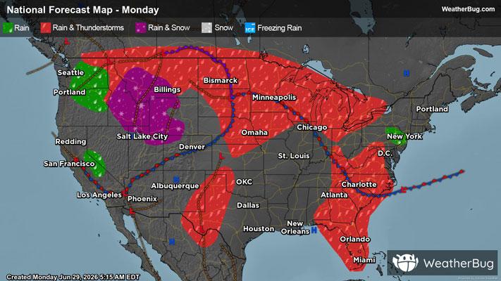
Severe Weather Underway For Northern Plains & Upper Midwest
A strengthening low pressure system will produce severe weather across the northern Plains and Upper Midwest today.
Read More
# HEADLINE -------------------- EXTREME HEAT WARNING REMAINS IN EFFECT FROM 9 AM THIS MORNING TO MIDNIGHT CDT TONIGHT # DETAILS -------------------- WHAT Dangerously hot conditions with heat index values up to 110 expected. WHERE Portions of central, east central, south central, southeast, and southwest Minnesota and northwest and west central Wisconsin. WHEN From 9 AM this morning to midnight CDT tonight. IMPACTS Heat-related illnesses increase significantly during extreme heat and high humidity events. ISSUED AT Monday, June 29, 2026 at 2:35 AM CDT ISSUED BY National Weather Service Twin Cities/Chanhassen MN HEADER URGENT - WEATHER MESSAGE # PRECAUTIONARY/PREPAREDNESS ACTIONS -------------------- Drink plenty of fluids, stay in an air-conditioned room, stay out of the sun, and check up on relatives and neighbors. # AREAS AFFECTED -------------------- Chisago, Eau Claire, Faribault, Le Sueur, Renville, Anoka, Barron, Benton, Blue Earth, Brown, Carver, Chippewa, Dakota, Dunn, Freeborn, Goodhue, Hennepin, Isanti, Kanabec, Kandiyohi, Martin, McLeod, Meeker, Mille Lacs, Morrison, Nicollet, Pepin, Pierce, Polk, Ramsey, Redwood, Rice, Scott, Sherburne, Sibley, St. Croix, Stearns, Steele, Waseca, Washington, Watonwan, Wright Including the cities of Chanhassen, Willmar, Rice Lake, Red Wing, Hastings, Center City, Faribault, Mankato, Owatonna, Blaine, Princeton, Stillwater, Little Falls, Waseca, St James, Blue Earth, Sauk Rapids, Olivia, St Paul, Chaska, Elk River, River Falls, Eau Claire, Chippewa Falls, Fairmont, New Ulm, Shakopee, Mora, Hutchinson, Durand, Victoria, St Cloud, Hudson, Gaylord, St Peter, Redwood Falls, Le Sueur, Menomonie, Litchfield, Albert Lea, Monticello, Osceola, Minneapolis, and Cambridge
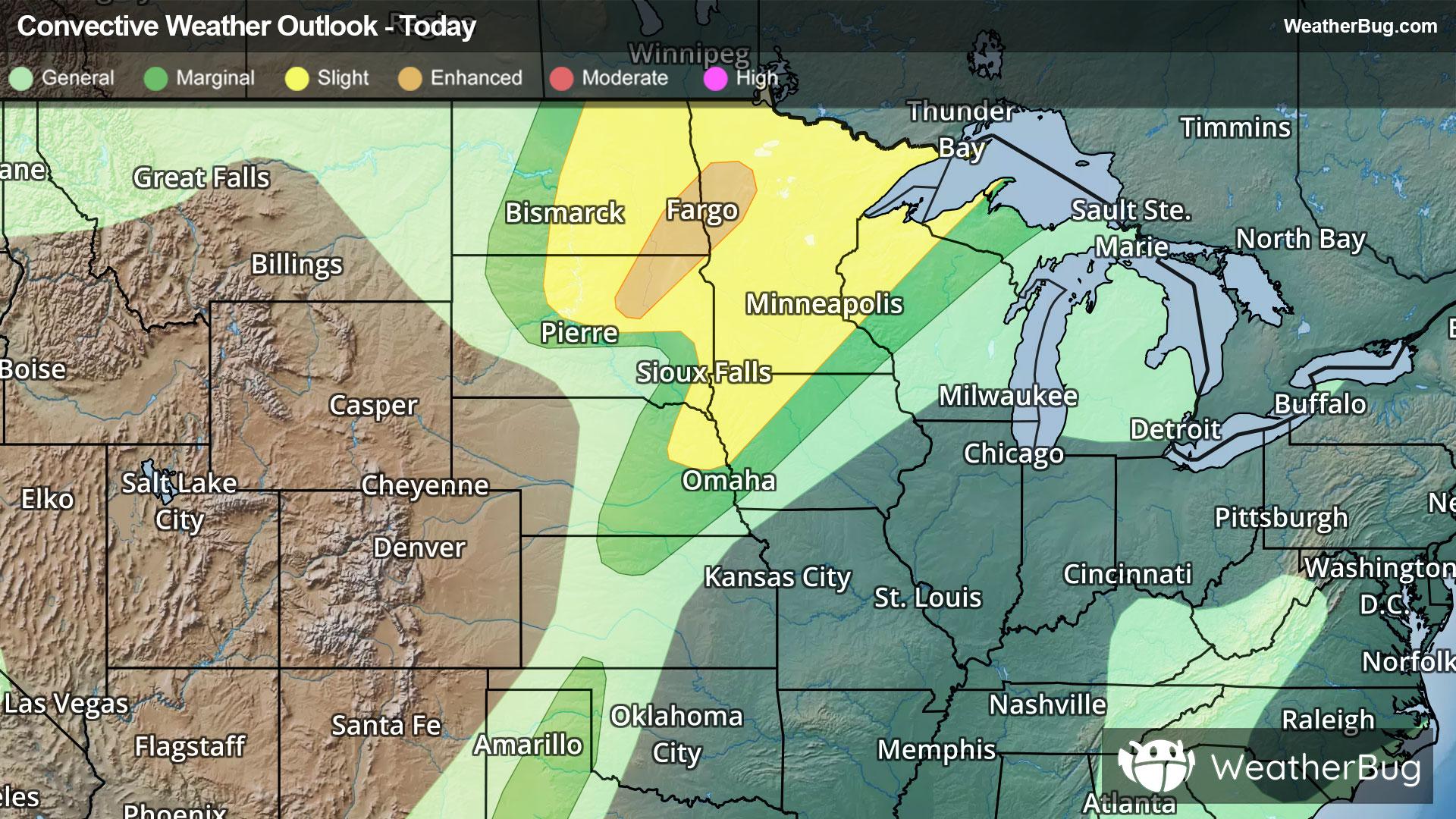
There is a Slight Severe Storm Risk for your location. Continue reading for today's outlook from the National Weather Service's Storm Prediction Center. -------------------- National Severe Storm Outlook THERE IS AN ENHANCED RISK OF SEVERE THUNDERSTORMS FROM NORTHEAST SOUTH DAKOTA INTO NORTHWEST MINNESOTA SUMMARY Severe thunderstorms capable of an intense swath of severe wind gusts are likely across northeast South Dakota into northwest Minnesota through midday. Later today, severe thunderstorms are possible from parts of the northern Plains into the Upper Midwest. Large hail and severe winds are the primary concerns, though a couple of tornadoes may also occur. Dakotas/Mid-Missouri Valley/Upper Midwest Water-vapor imagery this morning shows a mid-level shortwave trough over the central Rockies. This upper disturbance will acquire a negative tilt and move into the central Dakotas by early evening. A surface low over the north-central Plains will develop northward into eastern ND by 00z as a warm front advances northward across much of MN. Through midday, an intense supercell over northeast SD will continue to move quickly northeastward through parts of the eastern Dakotas this morning and into northwest MN. Recent CAM model guidance (i.e., time-lagged HRRR) has been remarkably consistent in showing the evolution of the SD thunderstorm complex into northern MN today. Have upgraded to an Enhanced Risk downstream of this extremely intense supercell evolving into a bow within a focused mesoscale corridor. Please refer to MCD #1376 for short-term forecast details. Later this afternoon, a very moist airmass will become very unstable over parts of the Upper Midwest. Isolated to scattered thunderstorms are forecast by late afternoon as large-scale ascent associated with the approaching upper wave overspreads the region. Ample deep-layer shear coupled with the large buoyancy will favor supercells. Large to very large hail, a couple of tornadoes, and severe gusts will be possible with this surface-based activity. Towards the early evening, additional storms are likely to develop farther east over MN with a hail/wind threat likely persisting through the evening. Kansas/Oklahoma/Texas Isolated high-based thunderstorms are possible near the dryline. Moderate instability is expected within this region with generally weak deep layer shear. Strong evaporatively cooled downdrafts will be capable of severe gusts with the more intense cores.
A strengthening low pressure system will produce severe weather across the northern Plains and Upper Midwest today.