Drenching Rain, Powerful Storms Pepper Eastern U.S., Near Front Range
Heavy rainfall and big thunderstorms could pepper the Eastern U.S. to begin the work week, while similar acitivity may occur near the Front Range.
Read More
# HEADLINE -------------------- FLOOD WATCH REMAINS IN EFFECT UNTIL 6 AM EDT TUESDAY # DETAILS -------------------- WHAT Flooding caused by excessive rainfall continues to be possible. WHERE Portions of northeast New Jersey, including the following areas, Eastern Bergen, Eastern Essex, Eastern Passaic, Eastern Union, Hudson, Western Bergen, Western Essex, Western Passaic and Western Union and southeast New York, including the following areas, Bronx, Kings (Brooklyn), New York (Manhattan), Northern Queens, Richmond (Staten Island) and Southern Queens. WHEN Until 6 AM EDT Tuesday. IMPACTS Excessive runoff may result in flooding of rivers, creeks, streams, and other low-lying and flood-prone locations. Flooding may occur in poor drainage and urban areas. ADDITIONAL DETAILS - Scattered heavy downpours and thunderstorms will produce rainfall rates of 1 to 2 inches per hour into the overnight. This will present a threat for scattered instances of urban, poor drainage, and quick responding small river and stream flash flooding, particularly over areas that saw heavy rain this afternoon. - After a brief respite in the rain late tonight into Tuesday morning, additional moderate to locally heavy rainfall on Tuesday may present a localized flash flood threat. - Http://www.weather.gov/safety/flood ISSUED AT Monday, June 22, 2026 at 10:52 PM EDT ISSUED BY National Weather Service New York NY HEADER Flood Watch # PRECAUTIONARY/PREPAREDNESS ACTIONS -------------------- You should monitor later forecasts and be alert for possible Flood Warnings. Those living in areas prone to flooding should be prepared to take action should flooding develop. # AREAS AFFECTED -------------------- New York (Manhattan), Bronx, Eastern Bergen, Eastern Essex, Eastern Passaic, Eastern Union, Hudson, Kings (Brooklyn), Northern Queens, Richmond (Staten Island), Southern Queens, Western Bergen, Western Essex, Western Passaic, Western Union
Closest strike: 26.17 miles Monitor Storms You are not at immediate risk, but frequently check WeatherBug to see if storms are moving towards you. Be aware that new storms can also form with little notice.
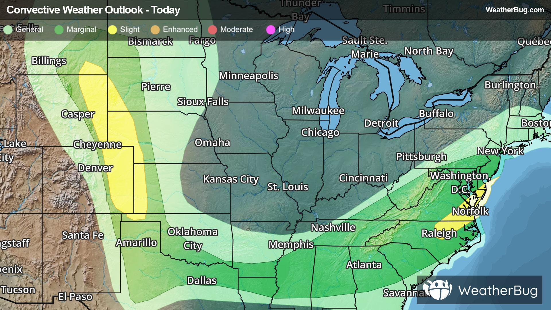
There is a Marginal Severe Storm Risk for your location. Continue reading for today's outlook from the National Weather Service's Storm Prediction Center. -------------------- National Severe Storm Outlook THERE IS A SLIGHT RISK OF SEVERE THUNDERSTORMS ACROSS THE CENTRAL HIGH PLAINS AND PARTS OF THE MID ATLANTIC SUMMARY Supercells and multicell clusters will continue to produce significant-severe wind/hail across the central High Plains this evening. Severe gusts and widn damage may accompany storms near the Mid-Atlantic coast through late evening. Tonight, isolated severe storms may occur across the southern Plains into the Middle Mississippi Valley. Synopsis A mid-level trough will advance toward the Mid-Atlantic Seaboard while a pronounced mid-level impulse ejects into the central/northern High Plains. At the surface, a trough will impinge on the East Coast while ongoing/developing storms continue to progress along a baroclinic boundary, from the Mid-MS Valley northwestward along the High Plains. Strong shear and buoyancy in both of these regimes will continue to foster severe potential into the evening hours. Mid Atlantic into the Southeast A well defined QLCS is tracking across the Mid-Atlantic, with more sporadic pulse-cellular/multicellular storms progressing over the Southeast. The QLCS will move offshore over the next hour, accompanied by a damaging gust threat. Across the Southeast, multicellular storms supported by the remnants of daytime heating or localized lift along MCVs appear to be on the wane. Nonetheless, 1000-2000 J/kg remnant MLCAPE will support localized wet downburst potential with some of the stronger storms over the next couple of hours. A brief tornado also cannot be ruled out with MCV storms across the TN Valley. High Plains Supercells remain in progress across the central to northern High Plains, where 2-3 inch in diameter hail and gusts well exceeding 75 mph have occurred. 2000+ J/kg MLCAPE, driven by 8+ C/km mid-level lapse rates, precede many of these supercells, so a severe wind/hail threat will continue with these storms for at least a few more hours. A tornado is also possible for supercells that remain inflow dominant. There is some chance that supercells could grow upscale into an MCS, which would traverse a surface boundary across the southern High Plains into the Southern Plains. Confidence in this scenario is quite low. However, should this evolution occur, severe gusts would be possible. Southern Plains into the Middle MS Valley Thunderstorms are initiating along a surface boundary, draped from the TX Panhandle into central MS. 2000-4000 J/kg MLCAPE and 30-50 kts of effective bulk shear overspreads this boundary, which would promote multicells and supercells with a severe wind/hail threat wherever storms mature. Nonetheless, forcing along this boundary is weak, so the severe threat should remain isolated through tonight.


