Severe Thunderstorms Set to Roam the Northern Plains
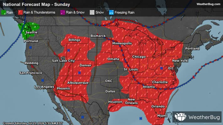
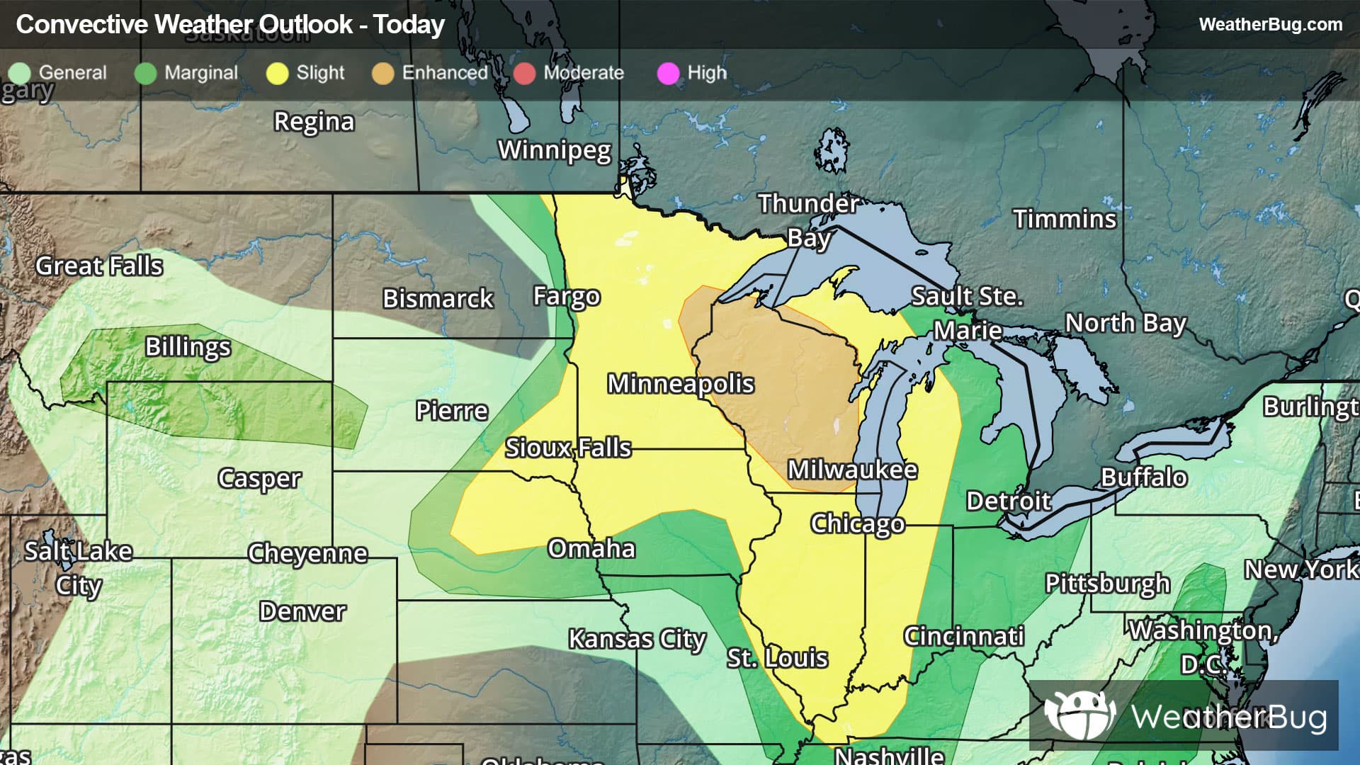
Severe weather may be found across the northern Plains this afternoon, with these storms slowly progressing east and reaching the East Coast by the early to middle part of next week.
Read More
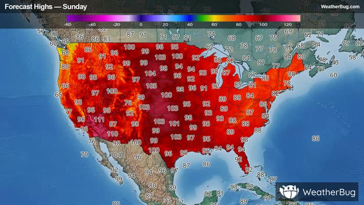
# HEADLINE -------------------- EXTREME HEAT WARNING IN EFFECT UNTIL 9 PM CDT THIS EVENING HEAT ADVISORY IN EFFECT FROM 9 PM THIS EVENING TO 7 PM CDT MONDAY EXTREME HEAT WATCH REMAINS IN EFFECT FROM MONDAY EVENING THROUGH TUESDAY EVENING # DETAILS -------------------- WHAT For the Extreme Heat Warning, dangerously hot conditions with peak heat index values of 108 to 115. For the Heat Advisory, peak heat index values of 103 to 108 expected. For the Extreme Heat Watch, dangerously hot conditions with peak heat index values of 103 to 107 possible. WHERE Geary, Lyon, Morris, Wabaunsee, Brown, Jackson, Jefferson, Nemaha, Pottawatomie, and Riley Counties. WHEN For the Extreme Heat Warning, until 9 PM CDT this evening. For the Heat Advisory, from 9 PM this evening to 7 PM CDT Monday. For the Extreme Heat Watch, from Monday evening through Tuesday evening. IMPACTS Heat related illnesses increase significantly during extreme heat and high humidity events. Hot temperatures and high humidity may cause heat cramps, heat exhaustion, and even heat stroke. ISSUED AT Sunday, July 26, 2026 at 2:08 AM CDT ISSUED BY National Weather Service Topeka KS HEADER URGENT - WEATHER MESSAGE # PRECAUTIONARY/PREPAREDNESS ACTIONS -------------------- Take extra precautions when outside. Wear lightweight and loose fitting clothing. Try to limit strenuous activities to early morning or evening. Take action when you see symptoms of heat exhaustion and heat stroke. To reduce risk during outdoor work, the Occupational Safety and Health Administration recommends scheduling frequent rest breaks in shaded or air conditioned environments. Anyone overcome by heat should be moved to a cool and shaded location. Heat stroke is an emergency! Call 9 1 1. Do not leave young children and pets in unattended vehicles. Car interiors will reach lethal temperatures in a matter of minutes. # AREAS AFFECTED -------------------- Wabaunsee, Brown, Geary, Jackson, Jefferson, Lyon, Morris, Nemaha, Pottawatomie, Riley Including the cities of Council Grove, Perry, McLouth, Manhattan, Sabetha, Emporia, Harveyville, Eskridge, Hiawatha, St. Marys, Alta Vista, Junction City, Valley Falls, Paxico, Wamego, Seneca, Grantville, Alma, Maple Hill, McFarland, Horton, Meriden, Oskaloosa, Holton, and Nortonville
# HEADLINE -------------------- EXTREME HEAT WARNING IN EFFECT UNTIL 9 PM CDT THIS EVENING HEAT ADVISORY IN EFFECT FROM 9 PM THIS EVENING TO 7 PM CDT MONDAY EXTREME HEAT WATCH REMAINS IN EFFECT FROM MONDAY EVENING THROUGH TUESDAY EVENING # DETAILS -------------------- WHAT For the Extreme Heat Warning, dangerously hot conditions with peak heat index values of 108 to 115. For the Heat Advisory, peak heat index values of 103 to 108 expected. For the Extreme Heat Watch, dangerously hot conditions with peak heat index values of 103 to 107 possible. WHERE Geary, Lyon, Morris, Wabaunsee, Brown, Jackson, Jefferson, Nemaha, Pottawatomie, and Riley Counties. WHEN For the Extreme Heat Warning, until 9 PM CDT this evening. For the Heat Advisory, from 9 PM this evening to 7 PM CDT Monday. For the Extreme Heat Watch, from Monday evening through Tuesday evening. IMPACTS Heat related illnesses increase significantly during extreme heat and high humidity events. Hot temperatures and high humidity may cause heat cramps, heat exhaustion, and even heat stroke. ISSUED AT Sunday, July 26, 2026 at 2:08 AM CDT ISSUED BY National Weather Service Topeka KS HEADER URGENT - WEATHER MESSAGE # PRECAUTIONARY/PREPAREDNESS ACTIONS -------------------- Take extra precautions when outside. Wear lightweight and loose fitting clothing. Try to limit strenuous activities to early morning or evening. Take action when you see symptoms of heat exhaustion and heat stroke. To reduce risk during outdoor work, the Occupational Safety and Health Administration recommends scheduling frequent rest breaks in shaded or air conditioned environments. Anyone overcome by heat should be moved to a cool and shaded location. Heat stroke is an emergency! Call 9 1 1. Do not leave young children and pets in unattended vehicles. Car interiors will reach lethal temperatures in a matter of minutes. # AREAS AFFECTED -------------------- Wabaunsee, Brown, Geary, Jackson, Jefferson, Lyon, Morris, Nemaha, Pottawatomie, Riley Including the cities of Council Grove, Perry, McLouth, Manhattan, Sabetha, Emporia, Harveyville, Eskridge, Hiawatha, St. Marys, Alta Vista, Junction City, Valley Falls, Paxico, Wamego, Seneca, Grantville, Alma, Maple Hill, McFarland, Horton, Meriden, Oskaloosa, Holton, and Nortonville
# HEADLINE -------------------- EXTREME HEAT WARNING IN EFFECT UNTIL 9 PM CDT THIS EVENING HEAT ADVISORY IN EFFECT FROM 9 PM THIS EVENING TO 7 PM CDT MONDAY EXTREME HEAT WATCH REMAINS IN EFFECT FROM MONDAY EVENING THROUGH TUESDAY EVENING # DETAILS -------------------- WHAT For the Extreme Heat Warning, dangerously hot conditions with peak heat index values of 108 to 115. For the Heat Advisory, peak heat index values of 103 to 108 expected. For the Extreme Heat Watch, dangerously hot conditions with peak heat index values of 103 to 107 possible. WHERE Geary, Lyon, Morris, Wabaunsee, Brown, Jackson, Jefferson, Nemaha, Pottawatomie, and Riley Counties. WHEN For the Extreme Heat Warning, until 9 PM CDT this evening. For the Heat Advisory, from 9 PM this evening to 7 PM CDT Monday. For the Extreme Heat Watch, from Monday evening through Tuesday evening. IMPACTS Heat related illnesses increase significantly during extreme heat and high humidity events. Hot temperatures and high humidity may cause heat cramps, heat exhaustion, and even heat stroke. ISSUED AT Sunday, July 26, 2026 at 2:08 AM CDT ISSUED BY National Weather Service Topeka KS HEADER URGENT - WEATHER MESSAGE # PRECAUTIONARY/PREPAREDNESS ACTIONS -------------------- Take extra precautions when outside. Wear lightweight and loose fitting clothing. Try to limit strenuous activities to early morning or evening. Take action when you see symptoms of heat exhaustion and heat stroke. To reduce risk during outdoor work, the Occupational Safety and Health Administration recommends scheduling frequent rest breaks in shaded or air conditioned environments. Anyone overcome by heat should be moved to a cool and shaded location. Heat stroke is an emergency! Call 9 1 1. Do not leave young children and pets in unattended vehicles. Car interiors will reach lethal temperatures in a matter of minutes. # AREAS AFFECTED -------------------- Wabaunsee, Brown, Geary, Jackson, Jefferson, Lyon, Morris, Nemaha, Pottawatomie, Riley Including the cities of Council Grove, Perry, McLouth, Manhattan, Sabetha, Emporia, Harveyville, Eskridge, Hiawatha, St. Marys, Alta Vista, Junction City, Valley Falls, Paxico, Wamego, Seneca, Grantville, Alma, Maple Hill, McFarland, Horton, Meriden, Oskaloosa, Holton, and Nortonville