Dangerous Storms Impact Northern Plains
Strong to severe thunderstorms will occur across the northern Plains today bringing risks that will impact travel.
Read More
# HEADLINE -------------------- HEAT ADVISORY REMAINS IN EFFECT FROM 9 AM MONDAY TO 7 PM CDT TUESDAY # DETAILS -------------------- WHAT Heat index values of 100 to 105 expected Monday afternoon and 95 to 100 Tuesday afternoon. Monday night heat indices will remain around or above 70 degrees, which will still be hazardous for anyone without shelter after the heat Monday afternoon. WHERE Price, Ashland, Bayfield, Iron, and Sawyer Counties. This includes the Tribal Lands of the northwestern area of the Lac du Flambeau Band, the Red Cliff Band, the Lac Courte Oreilles Reservation and the Bad River Reservation. Other locations including the Apostle Islands National Lakeshore and Madeline Island. WHEN From 9 AM Monday to 7 PM CDT Tuesday. IMPACTS Hot temperatures and high humidity may cause heat illnesses. ISSUED AT Sunday, June 28, 2026 at 11:59 PM CDT ISSUED BY National Weather Service Duluth MN HEADER URGENT - WEATHER MESSAGE # PRECAUTIONARY/PREPAREDNESS ACTIONS -------------------- Drink plenty of fluids, stay in an air-conditioned room, stay out of the sun, and check up on relatives and neighbors. # AREAS AFFECTED -------------------- Ashland, Bayfield, Iron, Price, Sawyer Including the cities of Hurley, Phillips, Hayward, Ashland, Washburn, and Bayfield
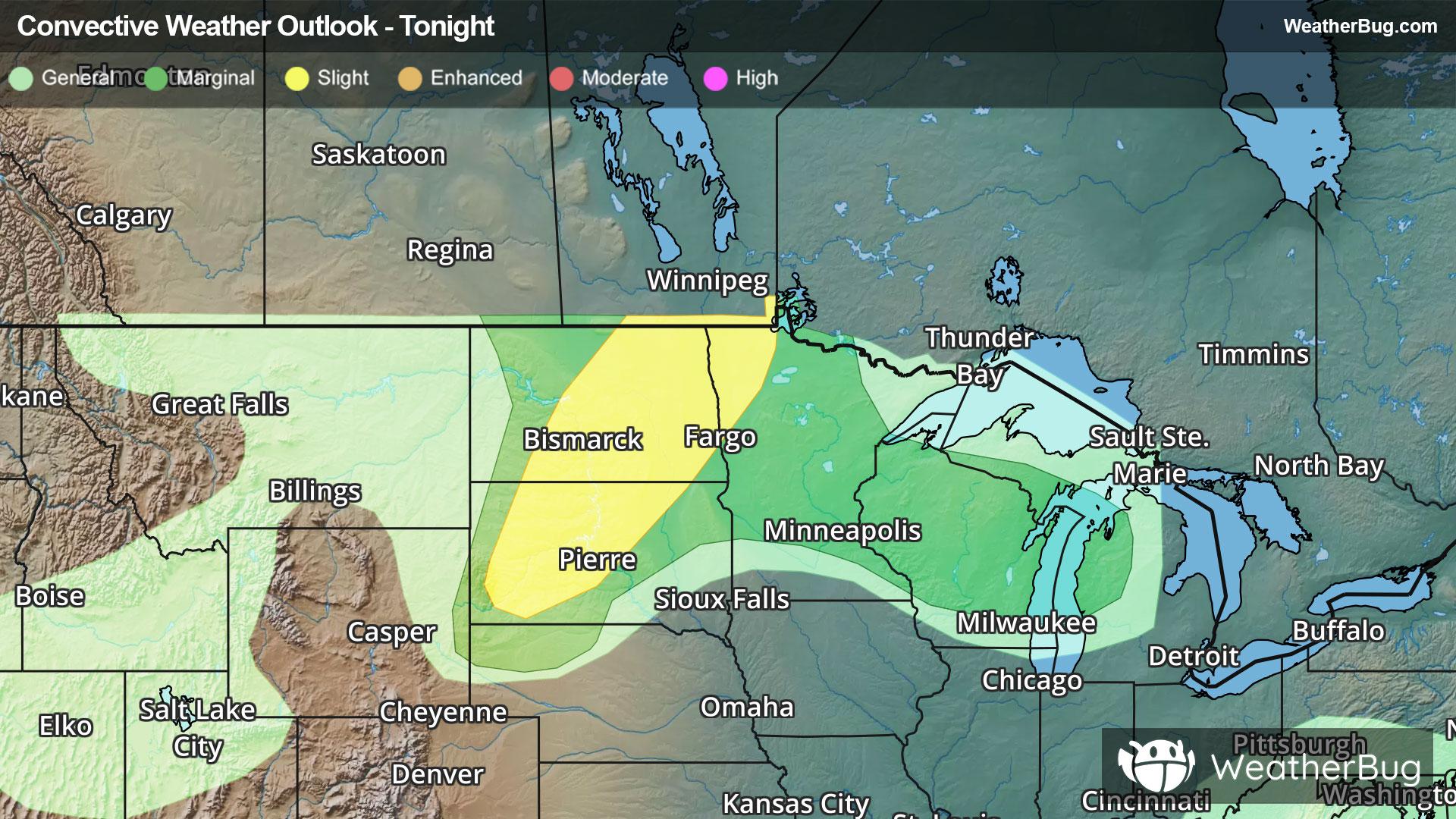
There is a Marginal Severe Storm Risk for your location. Continue reading for today's outlook from the National Weather Service's Storm Prediction Center. -------------------- National Severe Storm Outlook THERE IS A SLIGHT RISK OF SEVERE THUNDERSTORMS ACROSS PORTIONS OF THE NORTHERN PLAINS SUMMARY Severe thunderstorms are possible tonight across the Dakotas. Large to very large hail and severe winds are the primary hazards. More isolated severe storms capable of large will be possible in northern Wisconsin late tonight into early tomorrow morning. Discussion Water vapor imagery this evening shows a mid-level trough located across northern Montana into Alberta/Saskatchewan. At the surface, a low is occluding to the north across southern Alberta, with a secondary low developing across eastern Colorado. A surface cold front extends across portions of the western Dakotas north to the occluding front in Canada. As the surface low in Colorado deepens and moves northeastward late this evening, thunderstorm activity is expected to increase in coverage near the low/cold front and along a warm front lifting into the Upper Midwest. Northern Plains Initial thunderstorm development has occurred this evening within a zone of weak low-level convergence in central/western North Dakota as enhanced mid-level westerly flow overspreads the region from the trough to the west. Daytime heating and dew points in the upper 60s F have led to strong buoyancy across the region. Low-level flow is rather weak but deep layer shear around 50-55 kts will likely support a few isolated supercells capable of large to very large hail. See MCD#1369 for more information. Additional thunderstorm activity is progged to develop overnight as the surface low moves northward and forcing for ascent continues to increase. Aforementioned strong instability and deep layer shear profiles will support supercells capable of large to very large hail. The Slight Risk was maintained with this update to account for this potential overnight. See MCD#1370 for more information. Upper Midwest Thunderstorm development is expected along and north of a warm front lifting into northern Wisconsin late tonight into early Monday morning. As the warm front lifts northward, moisture and instability will increase from the south. Moderate to strong instability overlapping increasing deep layer shear from the trough to the west will support a mix of supercells and multi-cell clusters with potential for large hail. A Marginal Risk was maintained across central/northern Wisconsin and extended into the northern Lower Michigan Peninsula to account for this potential. West Texas A few stronger storms may continue across portions of western Texas near dryline and south to the Trans Pecos with a few instances of marginally severe hail and gusty winds. Loss of daytime heating should limit the duration of this risk past sunset with storms decreasing in coverage and intensity.
Strong to severe thunderstorms will occur across the northern Plains today bringing risks that will impact travel.


